Å, Lavangen
Å | |
|---|---|
Village | |
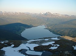 View of the village (left side of the fjord) | |
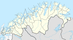 Å Location of the village | |
| Coordinates: 68°47′02″N 17°46′54″E / 68.78389°N 17.78167°ECoordinates: 68°47′02″N 17°46′54″E / 68.78389°N 17.78167°E | |
| Country | Norway |
| Region | Northern Norway |
| County | Troms og Finnmark |
| Municipality | Lavangen Municipality |
| Elevation | 15 m (49 ft) |
| Time zone | UTC+01:00 (CET) |
| • Summer (DST) | UTC+02:00 (CEST) |
| Post Code | 9357 Tennevoll |


Å is a village in Lavangen Municipality in Troms og Finnmark county, Norway. The village is located along the northern shore of the Lavangen fjord, about 4 kilometres (2.5 mi) north of the administrative centre of Tennevoll and about 52 kilometres (32 mi) east of the town of Harstad.
The population (2001) of the village was 79.[2] The southern part of the village area is called Soløy, and that is the location of Lavangen Church.
Name[]
The village (originally a farm) was first mentioned in 1610 ("Aa"). The name is from Old Norse á, which means "(small) river"
See also[]
- Å, Ibestad in Ibestad municipality, Troms, Norway
- Å, Tranøy in Tranøy municipality, Troms, Norway
References[]
- ^ "Å, Lavangen" (in Norwegian). yr.no. Retrieved 2012-09-10.
- ^ Statistisk sentralbyrå (2001). "Folke- og boligtellingen 2001, kommune- og bydelshefter 1920 Lavangen" (PDF) (in Norwegian). Cite journal requires
|journal=(help)
This article about a location in Troms og Finnmark is a stub. You can help Wikipedia by . |
Categories:
- Villages in Troms
- Lavangen
- Troms og Finnmark geography stubs