Île Australia
Native name: Île Australia Nickname: Île de Rennes | |
|---|---|
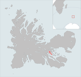 The Île Australia is highlighted on this Kerguelen Islands map. | |
| Geography | |
| Location | Indian Ocean |
| Coordinates | 49°27′S 69°50′E / 49.450°S 69.833°ECoordinates: 49°27′S 69°50′E / 49.450°S 69.833°E |
| Archipelago | Îles Kerguelen |
| Total islands | 1 |
| Major islands | Île Australia |
| Area | 37 km2 (14 sq mi)[1] |
| Length | 10 km (6 mi)[2] |
| Width | 3 km (1.9 mi)[2] |
| Coastline | 32 km (19.9 mi)[2] |
| Highest elevation | 145 m (476 ft).[2] |
| Highest point | Le stack de Tome |
| Administration | |
| District | Îles Kerguelen |
| Demographics | |
| Population | 0 |

Île Australia, also known as Île aux Rennes[1] (Reindeer Island) due to the presence of (introduced) reindeer is one of the Kerguelen Islands situated in the Golfe du Morbihan near the coast of Grande Terre, the principal island.
It is around 10 km long and 3 km wide. The highest spot is at 145 metres.
References[]
- ^ a b Tableau général de la France d'outremer, r.Brunet, Mappemonde nr.54, 1999; on General view of non-metropolitan France, Maison de la Géographie.
- ^ a b c d Kerguelen islands map, Géoportail IGN
This French Southern Territories location article is a stub. You can help Wikipedia by . |
Categories:
- Uninhabited islands of the Kerguelen Islands
- Non-metropolitan France geography stubs
- Subantarctic island geography stubs