Île Vierge
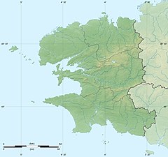
Île Vierge (Breton language: Enez-Werc'h) is a 6-hectare (15-acre)[1] islet lying 1.5 kilometres (0.93 mi) off the north-west coast of Brittany, opposite the village of Lilia.[2] It is in the commune of Plouguerneau, in the département of Finistère.[2] It is the location of the tallest stone lighthouse in Europe,[2][3] and the tallest "traditional lighthouse" in the world.[4] The International Hydrographic Organization specifies Île Vierge as marking the south-western limit of the English Channel.[5]
History[]
About 1450, the Conventual Franciscans established an abbey on the island.[2] The name "Île Vierge" probably comes from a chapel dedicated to the Blessed Virgin Mary.[2] In 1507, the monks moved to Aber Wrac'h on the mainland.[2] In 1844, the French state purchased the island [2] from sieur for 6,000 francs.[1]
The lighthouses[]
 | |
 | |
| Location | Île Vierge, Finistère France |
|---|---|
| Coordinates | 48°38′20″N 4°34′03″W / 48.638888°N 4.567493°W |
| Constructed | 1845 (first) |
| Construction | stone tower (first) granite tower (current) |
| Tower height | 31 metres (102 ft) (first) 82.5 metres (271 ft) (current) |
| Tower shape | square tower with balcony and lantern (first) tapered cylindrical tower with balcony and lantern (current) |
| Markings | white tower and lantern (first) unpainted tower, green lantern dome (current) |
| Heritage | monument historique classé |
| First lit | 1902 (current) |
| Automated | 2010, 2002 |
| Focal height | 77 metres (253 ft) (current) |
| Lens | 4 Fresnel lenses |
| Range | 50 kilometres (31 mi)[6] |
| Characteristic | Fl W 5s. |
| Admiralty no. | A1822 |
| NGA no. | 114-7716 |
| ARLHS no. | FRA-038[7] |


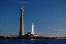
The first lighthouse was a square tower 33 metres (108 ft) high constructed in 1842–45.[2] It started operation on 15 August 1845,[2] feast day of the Assumption of the Virgin.[8] It had a fixed white light visible for 14 nautical miles (26 km; 16 mi).[2] It remained in use while the second lighthouse was under construction in 1896–1902. A foghorn was installed in 1952, replaced in 1993 by an electric beacon.[2]
The newer lighthouse is 82.5 metres (271 ft) tall, made of blocks of granite. The external face is a truncated cone; the interior face is cylindrical, lined with 12,500 opaline glass tiles made by Saint-Gobain.[2] There are five steps to the front door; inside, 360 steps of stone and 32 of iron lead to the lamp platform.[2] The electric lamp was installed in 1952 on the original mechanical turning plate, sitting in a bath of mercury.[2] The plate was replaced with an electric motor in 1983.[2] The lamp has four lenses with a focal length of 0.5m.[2] The twin beam gives a white flash every 5 seconds, visible for 27 nautical miles (50 km; 31 mi).[2] Electrical generators were installed in 1959, supplemented in 1967–1994 by two wind turbines.[2] The light and rotation are activated automatically by a photoelectric sensor.[2] Although the lighthouse is automated, the site is still staffed.[9]
The island is open to the public from April to September, as is the lighthouse, by appointment.[2] The number of visitors was 5,944 in 2003; 5,974 in 2004; 7,371 in 2005.[10] Both lighthouses are a listed monument since 2011.[3]
See also[]
- List of lighthouses in France
- List of tallest lighthouses in the world
Notes[]
- ^ Jump up to: a b "DDE 29: L'Île Vierge". DDE du Finistère (in French). Ministry of Ecology, Energy, Sustainable Development and Sea. 21 September 2005. Retrieved 20 December 2009.
- ^ Jump up to: a b c d e f g h i j k l m n o p q r s t "Phare de l'île Vierge". Sécurité maritime - Les Phares et Balises (in French). France: Ministry of Ecology, Energy, Sustainable Development and Sea. 30 June 2006. Retrieved 19 December 2009.
- ^ Jump up to: a b Base Mérimée: Phares de l'île Vierge, Ministère français de la Culture. (in French)
- ^ Rowlett, Russ. "The Tallest Lighthouses". The Lighthouse Directory. University of North Carolina at Chapel Hill.
- ^ Limits of Oceans and Seas (PDF) (3rd + corrections ed.). International Hydrographic Organization. 1971. p. 42 [corrections to page 13]. Retrieved 19 December 2009.
- ^ Jollands, Beverley; Fisher, Paul (2011). 100 Landmarks of the World. Parragon. pp. 92–93. ISBN 978-1-4454-3779-8.
- ^ Rowlett, Russ. "Lighthouses of France: Northern Finistère". The Lighthouse Directory. University of North Carolina at Chapel Hill. Retrieved January 21, 2016.
- ^ Lessard, Anne. "Le phare de l'île Vierge". Patrimoine maritime (in French). bretagne.com. Retrieved 20 December 2009.
- ^ "Automatisation programme" (PDF). Planete TP : tout sur les Travaux publics. Paris: ASCO-TP (Association pour la Connaissance des Travaux Publics). 18 February 2008. Retrieved 20 December 2009.
- ^ "4 – Le patrimoine des phares et balises" (MS Word). Phare d'Eckmühl, Commune de Penmarc'h: Travaux d'expertise du phare: Dossier de presse (in French). Direction départementale de l’Equipement du Finistère. p. 4. Retrieved 20 December 2009.
External links[]
- "Phare de l'île Vierge". Sécurité maritime - Les Phares et Balises (in French). France: Ministry of Ecology, Energy, Sustainable Development and Sea. 30 June 2006. Retrieved 19 December 2009.
- Ile Vierge, the highest lighthouse in Europe
 Media related to Île Vierge at Wikimedia Commons
- Islands of Brittany
- Lighthouses in Brittany
- Lighthouses completed in 1845
- Lighthouses completed in 1902
- Landforms of Finistère
- Tourist attractions in Finistère
- Monuments historiques of Finistère
- Round towers