Øksfjordjøkelen
| Øksfjordjøkelen (Norwegian) Ákšovuonjiehkki (Northern Sami) | |
|---|---|
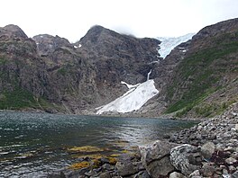 View of the Øksfjordjøkelen glacier | |
 Location of the glacier | |
| Type | Mountain Glacier |
| Location | Troms og Finnmark, Norway |
| Coordinates | 70°10′N 22°03′E / 70.167°N 22.050°ECoordinates: 70°10′N 22°03′E / 70.167°N 22.050°E |
| Area | 42 km2 (16 sq mi) |
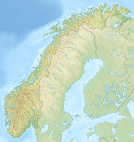

Øksfjordjøkelen (Norwegian) or Ákšovuonjiehkki (Northern Sami) is the ninth largest glacier in mainland Norway. The glacier is located in Troms og Finnmark county. The 42-square-kilometre (16 sq mi) glacier lies in both Loppa and Kvænangen municipalities.[1]
The highest point was earlier known to have an elevation of 1,204 metres (3,950 ft). It is now 1,191 metres (3,907 ft) due to glacier shrinkage.[2] But it still is, for the time being, the highest point in all of Troms og Finnmark county. The mountain Svartfjellet lies just north of the glacier in Loppa Municipality. That is another of the highest points in Finnmark county. The lowest point on the glacier has an elevation of 330 metres (1,080 ft). The village of Alteidet in Kvænangen is located nearby, along the European route E6.[3]
See also[]
References[]
- ^ Store norske leksikon. "Øksfjordjøkelen" (in Norwegian). Retrieved 2012-12-23.
- ^ "norgeskart.no" (in Norwegian).
- ^ "Fjelltopper i Nord" (in Norwegian).
This article about a location in Troms og Finnmark is a stub. You can help Wikipedia by . |
- Glaciers of Troms og Finnmark
- Kvænangen
- Loppa
- Glacier stubs
- Norway geography stubs
- Troms og Finnmark geography stubs