Čolnišče
Čolnišče | |
|---|---|
 | |
 Čolnišče Location in Slovenia | |
| Coordinates: 46°7′30.57″N 14°58′5.45″E / 46.1251583°N 14.9681806°ECoordinates: 46°7′30.57″N 14°58′5.45″E / 46.1251583°N 14.9681806°E | |
| Country | |
| Traditional region | Upper Carniola |
| Statistical region | Central Sava |
| Municipality | Zagorje ob Savi |
| Area | |
| • Total | 2.21 km2 (0.85 sq mi) |
| Elevation | 497.6 m (1,632.5 ft) |
| Population (2002) | |
| • Total | 194 |
| [1] | |

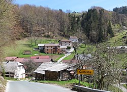
Čolnišče (pronounced [tʃɔu̯ˈniːʃtʃɛ]) is a settlement west of Zagorje ob Savi in central Slovenia. The area is part of the traditional region of Upper Carniola. It is now included with the rest of the municipality in the Central Sava Statistical Region.[2]
Geography[]
The main part of Čolnišče consists of two hamlets: Zgornje Čolnišče and Spodnje Čolnišče[3] (literally, 'upper' and 'lower' Čolnišče). Other hamlets in the settlement are Krbulje and Prečna. The village lies above a small valley with an intermittent spring; when it is flowing, the resulting stream disappears into the ground at Prečna. The soil is loamy and fertile.[3]
Church[]

The local church is dedicated to Saint Nicholas and belongs to the Parish of Šentlambert. It dates to the 17th century.[4]
References[]
- ^ Statistical Office of the Republic of Slovenia
- ^ Zagorje ob Savi municipal site
- ^ a b Savnik, Roman (1976). Krajevni leksikon Slovenije, vol. 3. Ljubljana: Državna založba Slovenije. p. 452.
- ^ Slovenian Ministry of Culture register of national heritage reference number ešd 2465
External links[]
- Čolnišče on Geopedia
 Media related to Čolnišče at Wikimedia Commons
| Settlements | Administrative seat: Zagorje ob Savi
|  | ||||
|---|---|---|---|---|---|---|
| Landmarks | ||||||
| Notable people | ||||||
This article about the Municipality of Zagorje ob Savi in Slovenia is a stub. You can help Wikipedia by . |
- Populated places in the Municipality of Zagorje ob Savi
- Zagorje ob Savi geography stubs