Ľubiša
Ľubiša | |
|---|---|
Village | |
 Skyline of Ľubiša in Slovakia | |
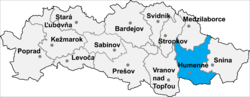 Location of Humenné District in the Prešov Region. | |
 Ľubiša Location of the Ľubiša village in Slovakia | |
| Coordinates: 49°00′10″N 21°56′50″E / 49.00278°N 21.94722°E | |
| Country | |
| Region | |
| District | Humenné |
| Status | Village |
| Government | |
| • Starosta Mayor | Jozef Sklenčár |
| • Term | 2014-2018 |
| Area | |
| • Total | 10.021 km2 (3.869 sq mi) |
| Elevation | 174 m (571 ft) |
| Population | |
| • Total | 840 |
| • Density | 84/km2 (220/sq mi) |
| Time zone | UTC+1:00 (CET) |
| • Summer (DST) | UTC+2:00 (CEST) |
| Postal code | 067 11 |

Ľubiša (Rusyn: Любіша, Hungarian: Szerelmes) is a village and municipality in Humenné District in the Prešov Region of north-east Slovakia.
History[]
In historical records[which?] the village was first mentioned in 1410.[citation needed]
Geography[]
The municipality lies at an altitude of 174 metres and covers an area of 10.021 km². It has a population of about 840 people.
External links[]
| Wikimedia Commons has media related to Ľubiša. |
Coordinates: 49°00′10″N 21°56′50″E / 49.00278°N 21.94722°E
This Prešov Region geography article is a stub. You can help Wikipedia by . |
Categories:
- Villages and municipalities in Humenné District
- Prešov Region geography stubs