Ťahanovce
Ťahanovce | |
|---|---|
Borough | |
 Overall view of Ťahanovce (February 2006) | |
 Flag  Coat of arms | |
 Location within Košice | |
| Country | Slovakia |
| Region | Košice |
| District | Košice I |
| Village | 1263 (first known record) |
| Borough | 1969 |
| Area | |
| • Total | 7.28 km2 (2.81 sq mi) |
| Elevation | 221 m (725 ft) |
| Population (2017) | |
| • Total | 2,529 |
| • Density | 350/km2 (900/sq mi) |
| Postal code | 04013 |
| Area code(s) | +421-55 |
| Car plate | KE |
| Website | www.tahanovce.eu |
| Source [1] | |
Ťahanovce (Hungarian: Hernádtihany, pronounced [ˈhɛrnaːttihɒɲ]) is a borough (city ward) of the city of Košice, Slovakia.
The first written mention about Ťahanovce is dated back to 1263. It was an independent village until 1969 when it was connected with Košice. Ťahanovce is home to approximately 2,000 (prevailingly elder) people and it is closely connected with the city part Sídlisko Ťahanovce.
Some of the historical names of the village Ťahanovce[]
- 1263 - Latin: predium Tehan (according to name of person)
- 1293 - possesio Thehan
- 1355 - villa Techan
- 1399 - Thehaan
- 1773 - Slovak: Czahanowcze; Hungarian: Téhany
- 1786 - Slovak: Czahanowecz; Hungarian: Téhány
- 1808 - Slovak: Tahanowce; Hungarian: Tehány
- 1863, 1892 - Hungarian: Tihany
- 1873 - Hungarian: Tihány
- 1888 - Hungarian: Abaújtihány
- 1907, 1938 - Hungarian: Hernádtihany
- 1920, 1945 - Slovak: Ťahanovce
Statistics[]
- Area: 7.28 km² (2016)
- Population: 2 529 (31 December 2017)
- Density of population: 350/km² (December 2017)
- District: Košice I
- Mayor: Ing. Ján Nigut
Gallery[]

Saint Anne church erected in 1850
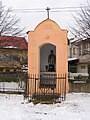
Saint John of Nepomuk´s chapel erected in 1913

Houses of Ťahanovce

Overall panorama of Ťahanovce and Sídlisko Ťahanovce


References[]
- ^ Mestská a obecná štatistika SR (urgently needs an updated statistics link for 2018) Archived 2007-04-27 at the Wayback Machine
External links[]
| Wikimedia Commons has media related to Ťahanovce. |
- Official website of the Ťahanovce borough
- Article on the Ťahanovce borough at Cassovia.sk (in Slovak)
- Official website of Košice
Coordinates: 48°45′N 21°15′E / 48.750°N 21.250°E

| show Authority control |
|---|
Categories:
- Boroughs of Košice
- Villages in Slovakia merged with towns