1857 Basilicata earthquake
Coordinates: 40°30′N 16°30′E / 40.5°N 16.5°E

 | |
 | |
| Local date | December 16, 1857 |
|---|---|
| Magnitude | 7.0 Mw (est) [1] |
| Epicenter | Basilicata |
| Areas affected | Kingdom of the Two Sicilies |
| Max. intensity | XI (Extreme) [1] |
| Casualties | 10,000 dead [2] |
The 1857 Basilicata earthquake (also known as the Great Neapolitan earthquake) occurred on December 16 in the Basilicata region of Italy southeast of the city of Naples. The epicentre was in Montemurro, on the western border of the modern province of Potenza. Several towns were destroyed, and estimated fatalities were around 10,000. At the time it was the third-largest known earthquake and has been estimated to have been of magnitude 7.0 on the moment magnitude scale.
Earthquake[]
The principal shock occurred at about 10pm on December 16, 1857, and had been preceded by minor disturbances and was followed by numerous aftershocks which continued for some months.
Effects[]
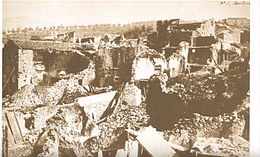
The earthquake was felt as far away as Terracina to the northwest, the main places suffering damage being Potenza, Polla, Diano, Sala, and Padula in the Val di Diano, and Tito, Sarconi, Spinoso, Marsico Nuovo, Saponara, and Montemurro. The latter two places, along with Padula and Polla, were virtually completely destroyed.
Scientific study[]
Early in 1858, aided by a grant from the Royal Society, Robert Mallet visited the devastated area, and spent over two months studying the effects of the disaster, paying special attention to the damage caused to buildings. His extensive report was published in 1862 and remains a memorable work in the history of seismology. It is believed that Mallet was the first to use photography to record the aftermath of an earthquake.[3]
Much of Mallet's work was devoted to determining the position and magnitude of the subterranean focus of the earthquake. He calculated that the focal cavity was a curved fissure, about 10 miles (16 km) long and 31 miles (50 km) high and of negligible width. He estimated that the central point of the fissure, the theoretical seismic centre, was 62 miles (100 km) deep. Mallet located his epicentre near the village of Caggiano, not far from Polla, but later examination of his data suggested that there was a second focus near Montemurro, about 25 miles (40 km) to the southeast.
See also[]
- List of earthquakes in Italy
- List of historical earthquakes
- List of historical tsunamis
References[]
- ^ a b Burrato, P.; Valensise G. (2008). "Rise and Fall of a Hypothesized Seismic Gap: Source Complexity in the Mw 7.0 16 December 1857 Southern Italy Earthquake" (PDF). Bulletin of the Seismological Society of America. Seismological Society of America. 98 (1): 140, 144. Bibcode:2008BuSSA..98..139B. doi:10.1785/0120070094.
- ^ National Geophysical Data Center / World Data Service (NGDC/WDS) (1972), Significant Earthquake Database (Data Set), National Geophysical Data Center, NOAA, doi:10.7289/V5TD9V7K
- ^ "Robert Mallet – the earthquake detective". 23 November 2011. Archived from the original on 2 November 2013. Retrieved 5 January 2013.
- Notes
- Mallet, R. (1862). Great Neapolitan Earthquake of 1857: The First Principles of Observational Seismology. Royal Society.
- Earthquakes in Italy
- History of Basilicata
- History of Campania
- 1857 in Italy
- 1857 earthquakes
- December 1857 events