1893 Atlantic hurricane season
This article needs additional citations for verification. (May 2020) |
| 1893 Atlantic hurricane season | |
|---|---|
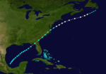
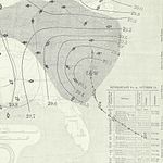
 Season summary map | |
| Seasonal boundaries | |
| First system formed | June 12, 1893 |
| Last system dissipated | November 9, 1893 |
| Strongest storm | |
| Name | "Cheniere Caminada" |
| • Maximum winds | 130 mph (215 km/h) (1-minute sustained) |
| • Lowest pressure | 948 mbar (hPa; 27.99 inHg) |
| Seasonal statistics | |
| Total depressions | 12 |
| Total storms | 12 |
| Hurricanes | 10 |
| Major hurricanes (Cat. 3+) | 5 |
| Total fatalities | ~4,028 |
| Total damage | At least $6 million (1893 USD) |
The 1893 Atlantic hurricane season ran through the summer and the first half of fall in 1893. The 1893 season was fairly active, with 12 tropical storms forming, 10 of which became hurricanes. Of those, five became major hurricanes. This season proved to be a very deadly season, with two different hurricanes each causing over 2,000 deaths in the United States; at the time, the season was the deadliest in U.S. history. The season was one of two seasons on record to see four Atlantic hurricanes active simultaneously, along with the 1998 Atlantic hurricane season. Additionally, August 15, 1893 was the only time since the advent of modern record keeping that three storms have formed on the same day (Hurricanes Four, Five, and Six) until 2020 saw Wilfred, Alpha, and Beta forming on the same day.
Timeline[]

Systems[]
Hurricane One[]
| Category 1 hurricane (SSHWS) | |
  | |
| Duration | June 10 – June 19 |
|---|---|
| Peak intensity | 80 mph (130 km/h) (1-min) 990 mbar (hPa) |
Observations from ships indicated the presence of a tropical storm in the Bay of Campeche on June 12.[1] The storm moved northeastward across the Gulf of Mexico and intensified into a strong tropical storm. Around 23:00 UTC on June 15, the system made landfall southwest of Perry, Florida, with winds of 70 mph (110 km/h). The cyclone weakened somewhat while moving over Florida and coastal portions of Georgia and the Carolinas. After emerging into the Atlantic near the North Carolina–Virginia state line early on June 17, the storm strengthened, reaching hurricane intensity later that day.[2] On June 19, a ship located in the vicinity of the storm recorded a barometric pressure around 999 mbar (29.5 inHg) - the lowest in relation to the cyclone.[1] However, the system then became losing tropical characteristics and transitioned into an extratropical cyclone about 155 mi (250 km) south of Saint Pierre and Miquelon by 00:00 UTC on June 20.[2]
Several locations in the Southeastern United States observed tropical storm-force winds, with the strongest recorded sustained wind speed being 56 mph (90 km/h) in Charleston, South Carolina.[1]
Hurricane Two[]
| Category 2 hurricane (SSHWS) | |
 | |
| Duration | July 4 – July 7 |
|---|---|
| Peak intensity | 100 mph (155 km/h) (1-min) |
Observations of this storm began as early as July 4 in the southwestern Caribbean Sea,[1] with a ship encountering the cyclone about 130 mi (210 km) north-northeast of Colón, Panama. The system intensified steadily while moving northwestward, becoming a hurricane around 12:00 UTC on the following day. About six hours later, the storm intensified into a Category 2 hurricane and peaked with winds of 100 mph (155 km/h). The hurricane then made landfall near the Nicaragua–Honduras border. The cyclone weakened back to a Category 1 before re-emerging into the Caribbean off the north coast of Honduras early on July 6. Continuing northwestward, the system then re-strengthened slightly, reaching winds of 90 mph (150 km/h) prior to making landfall in northern Belize around 00:00 UTC on July 7. The cyclone weakened rapidly over the Yucatán Peninsula and dissipated just offshore Tabasco several hours later.[2]
The storm sank several ships, including many steamers loaded with fruit in Honduras. About 6,000 bunches of bananas awaiting shipment were washed away at Bonito, while fruit plantations also experienced extensive damage. A number of homes on Roatán were also severely damaged.[3] The hurricane reportedly caused a large loss of life.[1] It has been paleotempestologically traced in sediment near Gales Point in Belize.[4]
Hurricane Three[]
| Category 3 hurricane (SSHWS) | |
  | |
| Duration | August 13 – August 22 |
|---|---|
| Peak intensity | 120 mph (195 km/h) (1-min) 956 mbar (hPa) |
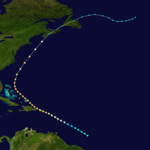
Hurricane San Roque of 1893
The third storm of the season formed on August 13 east of the Lesser Antilles. It steadily strengthened to a hurricane while moving over the Leeward Islands. While approaching Puerto Rico on August 16, its winds increased to major hurricane status before landfall at Patillas. It crossed the island and exited near Isabela.[5] There were heavy rains over the island of Puerto Rico and damages to the agricultural crops, especially coffee. In San Juan 2.36 inches of rain were reported.[5] The eye remained over Puerto Rico for a period of seven hours. The lowest barometric pressure reading recorded in San Juan was 29.17 inches. Four deaths were reported. This was the first hurricane in Puerto Rico where flags were used to alert the public about the danger of an approaching hurricane; they were flown from government buildings.[5][6]
Although landfall weakened the storm, the storm regained major hurricane status as it approached the Bahamas. It then re curved northward and on August 22, made landfall in St. Margaret's Bay near Halifax, Nova Scotia as a non-tropical category 1. The storm was known in Nova Scotia as "the second Great August Gale" and claimed 25 lives, including the sinking of the vessels "Dorcas" and "Etta Stewart."[7]
This hurricane was one of four active hurricanes on August 22.
Hurricane Four[]
| Category 3 hurricane (SSHWS) | |
  | |
| Duration | August 15 – August 24 |
|---|---|
| Peak intensity | 115 mph (185 km/h) (1-min) 952 mbar (hPa) |
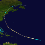
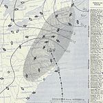
The New York Hurricane of 1893
The 4th storm of the season began its life in the Central Tropical Atlantic on August 15. The storm moved west-northwestward for the first week of its life, while strengthening on the way. As it reached Category 3 strength, it moved more northwestward. Cooler waters weakened the storm, but it managed to hit New York City directly as an 85 mph (137 km/h) hurricane. It was one of only two hurricanes to directly hit New York throughout the 19th century, with the other being the 1821 Norfolk and Long Island hurricane. This storm was one of four active hurricanes on August 22.[citation needed]
Hurricane Five[]
| Category 2 hurricane (SSHWS) | |
 | |
| Duration | August 15 – August 19 |
|---|---|
| Peak intensity | 100 mph (155 km/h) (1-min) |
The 5th storm of the season started east of Bermuda on August 15. After moving northwestward for a day, it moved northeastward and strengthened to a Category 2 hurricane. The storm crossed Sable Island at peak intensity, before hitting the Burin Peninsula of Newfoundland on August 18 as a 90 mph (145 km/h) hurricane, and dissipated the day after.[citation needed]
Hurricane Six[]
| Category 3 hurricane (SSHWS) | |
  | |
| Duration | August 15 – August 30 |
|---|---|
| Peak intensity | 120 mph (195 km/h) (1-min) 954 mbar (hPa) |
The Sea Islands Hurricane of 1893
The 6th storm of the season formed near Cape Verde on August 15. The storm moved generally westward for the first 11 days of its life, during which it strengthened to a Category 3 hurricane. As it approached the Bahamas, it moved more northwestward, paralleling the coast of Florida. The storm hit near Savannah, Georgia and was responsible for the deaths of 2,000 people as the storm submerged the South Carolina barrier islands. It moved northeastward, and underwent extratropical transition on August 31. This hurricane was one of four active hurricanes on August 22.[citation needed]
Hurricane Seven[]
| Category 2 hurricane (SSHWS) | |
 | |
| Duration | August 20 – August 29 |
|---|---|
| Peak intensity | 100 mph (155 km/h) (1-min) |
The 7th storm of the season formed near the Cape Verde islands on August 20. It moved northwestward, reaching Category 2 hurricane strength on August 23. The hurricane maintained its strength until August 28, when cooler waters led the storm to extratropical transition. This storm was one of four active hurricanes on August 22. This hurricane could be one of the strongest tropical cyclones to have passed the Azores in the previous 100 years. It caused significant casualties and damages at Faial and Terceira islands that were documented afterwards (M. Lima, and J. Agostinho).[citation needed]
At least five lives were lost.[8]
Hurricane Eight[]
| Category 2 hurricane (SSHWS) | |
  | |
| Duration | September 4 – September 9 |
|---|---|
| Peak intensity | 100 mph (155 km/h) (1-min) 973 mbar (hPa) |
The 8th storm of the season formed in the western Caribbean Sea on September 4. After hitting the Yucatán Peninsula, it strengthened in the Gulf of Mexico to a 95 mph (153 km/h) hurricane. It hit the southern coast of Louisiana on September 7, and dissipated over northeastern Alabama.[citation needed]
Hurricane Nine[]
| Category 3 hurricane (SSHWS) | |
  | |
| Duration | September 25 – October 14 |
|---|---|
| Peak intensity | 120 mph (195 km/h) (1-min) 955 mbar (hPa) |
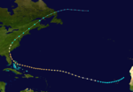
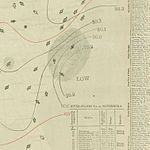
The Great Charleston Hurricane of 1893
The 9th storm of the season was formed southwest of Cape Verde on September 25. It moved westward for the first 8 days of its life then it moved more northwestward. During this time it strengthened to a major hurricane, and it maintained its strength until landfall. As it bypassed the Bahamas, it moved more northward, and made landfall near Myrtle Beach, South Carolina on October 13 with winds around 120 mph (190 km/h). It moved through North Carolina and the Appalachian Mountains, was still a Category 1 Hurricane as it passed 60 miles west of Washington, D.C.. It became extratropical on October 14. The center crossed middle of Lake Ontario causing major damage in Lake Erie and Buffalo, New York. 10 ships lost and 29 stranded with 54 lives lost in the Lakes ship wrecks alone.[9]
The hurricane had an estimated Accumulated Cyclone Energy of 63.5, one of the highest of any historical Atlantic hurricane. This storm lasted 19.25 days making it the 10th longest-lasting in Atlantic tropical cyclone on record since records began in 1851.[citation needed]
Hurricane Ten[]
| Category 4 hurricane (SSHWS) | |
  | |
| Duration | September 27 – October 5 |
|---|---|
| Peak intensity | 130 mph (215 km/h) (1-min) 948 mbar (hPa) |
The Cheniere Caminada Hurricane
This section may be confusing or unclear to readers. (May 2020) |
The 10th storm of the season began on September 27 in the western Caribbean Sea. After hitting the northeastern coast of the Yucatán Peninsula as a Category 2 hurricane, it moved through the Gulf of Mexico. As it approached the southeast coast of Louisiana, it rapidly strengthened to a Category 4 hurricane, and made landfall on October 2 as a category 4 hurricane. It moved through Alabama, Georgia, and the Carolinas before dissipating at sea. This storm was one of the first hurricanes to officially receive a Category 4 designation on the modern Saffir-Simpson scale. The hurricane flooded the Louisiana bayou with up to 16 foot storm surge with heavy surf above it and killed 2,000 people mostly by drowning and caused around $5 million (1893 dollars) in damage.[citation needed]
Tropical Storm Eleven[]
| Tropical storm (SSHWS) | |
  | |
| Duration | October 20 – October 23 |
|---|---|
| Peak intensity | 60 mph (95 km/h) (1-min) |
The 11th storm of the season formed just south of the Isla de la Juventud on October 20. After moving through Cuba, it strengthened to a 60 mph (97 km/h) storm before it hit the Delmarva Peninsula on October 23.[citation needed]
Tropical Storm Twelve[]
| Tropical storm (SSHWS) | |
  | |
| Duration | November 5 – November 9 |
|---|---|
| Peak intensity | 70 mph (110 km/h) (1-min) |
The 12th and final storm of the season formed northeast of the Bahamas on November 5. The storm moved northwestward, almost hitting North Carolina as a strong tropical storm, but went out to sea, becoming extratropical on November 10.[citation needed]
See also[]
References[]
- ^ Jump up to: a b c d e Jose Fernandez-Partagas (1996). Year 1893 (PDF). Atlantic Oceanographic and Meteorological Laboratory (Report). National Oceanic and Atmospheric Administration. Retrieved August 23, 2019.
- ^ Jump up to: a b c "Atlantic hurricane best track (HURDAT version 2)" (Database). United States National Hurricane Center. May 25, 2020.
- ^ "Storm in Honduras". Evening Messenger. July 15, 1893. p. 2. Retrieved August 26, 2019 – via Newspapers.com.

- ^ McCloskey, T. A.; Keller, G. (2009). "5000 year sedimentary record of hurricane strikes on the central coast of Belize". Quaternary International. 195 (1–2): 53–68. Bibcode:2009QuInt.195...53M. doi:10.1016/j.quaint.2008.03.003.
- ^ Jump up to: a b c Mújica-Baker, Frank. Huracanes y Tormentas que han afectadi a Puerto Rico (PDF). Estado Libre Asociado de Puerto Rico, Agencia Estatal para el manejo de Emergencias y Administracion de Desastres. p. 10. Archived from the original (PDF) on October 1, 2015. Retrieved August 30, 2010.
- ^ "Hurricanes and Tropical Storms in Puerto Rico from 1500 to 1899". Retrieved December 29, 2010.
- ^ Bowyer, Peter. "Hurricane Juan Storm Summary". ec.gc.ca. Environment Canada. Retrieved September 5, 2019.
- ^ https://cdnc.ucr.edu/cgi-bin/cdnc?a=d&d=LAH18930903.2.3
- ^ "The Great Storm of 1893 and the Schooner Riverside" (PDF). clueshipwrecks.org. Retrieved 3 January 2021.
External links[]
- 1893 Atlantic hurricane season