1918 San Fermín earthquake
 Mayagüez San Juan | |
| UTC time | 1918-10-11 14:14:42 |
|---|---|
| ISC event | 913306 |
| USGS-ANSS | ComCat |
| Local date | October 11, 1918 |
| Local time | 10:14:42 [1] |
| Magnitude | 7.1 Mw[1] |
| Depth | 15 km (9.3 mi) [1] |
| Epicenter | 18°48′N 67°13′W / 18.8°N 67.22°WCoordinates: 18°48′N 67°13′W / 18.8°N 67.22°W [1] |
| Type | Unknown |
| Areas affected | Puerto Rico |
| Total damage | $4–29 million USD [2][3] |
| Max. intensity | IX (Violent) [3] |
| Tsunami | Yes |
| Casualties | 76–118 [2][4] |
The 1918 San Fermín earthquake,[5][6] also known as the Puerto Rico earthquake of 1918, struck the island of Puerto Rico at 10:14:42 local time on October 11. The earthquake measured 7.1 on the moment magnitude scale and IX (Violent) on the Mercalli intensity scale. The mainshock epicenter occurred off the northwestern coast of the island, somewhere along the Puerto Rico Trench.
The earthquake triggered a tsunami with waves measured that swept the west coast of the island. The combined effects of the earthquake and tsunami made it one of the worst natural disasters that have struck the island. The losses resulting from the disaster were approximately 76–118 casualties[4] and $4–29 million in property damage.
Earthquake[]
The epicenter of the 1918 San Fermín earthquake was located in the Mona Passage off the northwestern coast of the island. The strongest ground shaking has been estimated at intensity IX on the Mercalli intensity scale. The resulting tsunami affected primarily the west coast towns of the island (primarily Mayaguez).
Damage[]

Numerous structures in the west coast suffered irreparable damage. Factories and production facilities were virtually destroyed, while bridges and roads were severely damaged. The earthquake caused several mudslides in areas where the intensity exceeded Level VII, but none caused numerous deaths. Also, the river currents were affected, which, in many cases affected the foundations of many bridges, resulting in their collapse. Telegraph cables under the ocean were damaged, cutting off the island from outside communication for a time.[7]

The reported casualties of the earthquake have been estimated somewhere between 76 and 116 deaths. Approximately 40 of these deaths were caused by the tsunami which swept shore communities. Damage to property was estimated to be between $4 and 29 million.
In Mayagüez, the largest city affected, 700 masonry buildings were damaged and 1,000 wooden houses, so many people were homeless. Major buildings like the church, post office and hall were severely damaged. With fear because of the aftershocks, many people camped out in the hills for weeks.[7]
Tsunami[]
As a result of the earthquake, a tsunami lashed the west coast of the island, probably 4–7 minutes after the main shock. The highest waves were estimated at 6.0 m (19.7 ft) in Point Agujereada, 4.5 m (15 ft) at Point Borinquen, and 5.2 m (17 ft) at Point Jiguero.[8] Several coastal villages were destroyed and it has been estimated that 40 people drowned (32 in Aguadilla alone) as a direct result of the tsunami.[9]
Aftershocks[]
Several aftershocks were reported immediately after the main earthquake. On October 24 and November 12, two strong aftershocks were reported on the island. However, no damage was reported as a result.
United States response[]
The response from the United States was to exempt the municipalities most affected from paying taxes for a short period immediately following the quake: those municipalities were Mayagüez, Aguada, Aguadilla, Añasco and Isabela. The U.S. appropriated funds for the repair of municipal buildings of the most affected municipalities.[10]
Gallery[]

Cathedral of Mayagüez after the first earthquake; further damage toppled the left tower

Destroyed brick homes in Mayagüez

Map showing the epicenters of all the magnitude 5 and greater earthquakes around Puerto Rico for the last 100 years
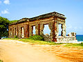
Aguadilla Punta Borinquen Lighthouse Ruins—an 1889 lighthouse destroyed by the tsunami


See also[]
- 1787 Boricua earthquake
- 1867 Virgin Islands earthquake and tsunami
- 2019–20 Puerto Rico earthquakes
- Geology of Puerto Rico
- List of disasters in the United States by death toll
- List of earthquakes in 1918
- List of earthquakes in Puerto Rico
- List of earthquakes in the Caribbean
References[]
- ^ a b c d ISC (2016), ISC-GEM Global Instrumental Earthquake Catalogue (1900–2012), Version 3.0, International Seismological Centre
- ^ a b USGS (September 4, 2009), PAGER-CAT Earthquake Catalog, Version 2008_06.1, United States Geological Survey, archived from the original on 2020-03-13
- ^ a b National Geophysical Data Center / World Data Service (NGDC/WDS) (1972), Significant Earthquake Database, National Geophysical Data Center, NOAA, doi:10.7289/V5TD9V7K
- ^ a b "Tsunami Hazards—A National Threat A Real Risk for the United States". USGS.gov. March 6, 2018. Retrieved August 19, 2018.
- ^ Subcomite de la Historia de Mayagüez (1960), Historia de Mayagüez 1760–1960 (in Spanish), Talleres Graficos Interamericanos, retrieved September 7, 2010
- ^ Millie Gil. A 92 años del Terremoto de San Fermín, 1918. Mayaguez Sabe a Mango. 17 October 2010.
- ^ a b Peter Aviles, "The Earthquake of the Century", 2002, hosted at University of Puerto Rico, accessed 24 October 2013
- ^ "1918 PUERTO RICO TSUNAMI". USC Tsunami Research Group. Archived from the original on April 30, 2005. Retrieved August 19, 2018.
- ^ "Los Cascos Urbanos Hablan: Aguadilla 2/3". florida.pbslearningmedia.org/ (in Spanish). Puerto Rico National Endowment for the Humanities. Retrieved 9 February 2021.
- ^ United States. Congress (1919). Congressional Edition. U.S. Government Printing Office. pp. 12–16. Retrieved July 31, 2019.
Sources
- Hornbach, M.J.; Mondziel, S.A.; Grindlay, N.R.; Frohlich, C.; Mann, P. (2008), "Did a submarine landslide trigger the 1918 Puerto Rico tsunami?" (PDF), Science of Tsunami Hazards, Tsunami Society, 27 (2): 22–31
- Reid, H. (1919), "The Porto Rico Earthquakes of October–November, 1918", Bulletin of the Seismological Society of America, Seismological Society of America, 9 (4): 95–127, archived from the original on September 23, 2015
- McCann, W. (1985), "On the earthquake hazards of Puerto Rico and the Virgin Islands", Bulletin of the Seismological Society of America, Seismological Society of America, 75 (1): 251–262, archived from the original on September 23, 2015
External links[]
- "Puerto Rico Seismic Network" – University of Puerto Rico, Mayaguez
- Significant earthquake – Puerto Rico: Mona Passage – National Geophysical Data Center
- M 7.1 - Puerto Rico region – United States Geological Survey
- The Tectonic Setting and Geology of Puerto Rico and Its Surrounding Seafloor – National Oceanic and Atmospheric Administration
- Map of Tsunami wave heights in Puerto Rico by USC Tsunami Research Group
- Wave transformation in Coastal Wiki
- Earthquakes and Tsunamis in Puerto Rico and the U.S. Virgin Islands by USGS.gov
- The International Seismological Centre has a bibliography and/or authoritative data for this event.
| Historical |
| |
|---|---|---|
| 20th century |
| |
| 21st century |
| |
- Mayagüez, Puerto Rico
- 1918 earthquakes
- 1918 in Puerto Rico
- 1918 tsunamis
- Earthquakes in Puerto Rico