1978–79 South Pacific cyclone season
| 1978–79 South Pacific cyclone season | |
|---|---|
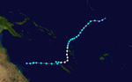
 Season summary map | |
| Seasonal boundaries | |
| First system formed | December 27, 1978 |
| Last system dissipated | April 17, 1979 |
| Strongest storm | |
| Name | Meli |
| • Maximum winds | 155 km/h (100 mph) (10-minute sustained) |
| • Lowest pressure | 945 hPa (mbar) |
| Seasonal statistics | |
| Total depressions | 9 |
| Tropical cyclones | 6 official, 2 unofficial |
| Severe tropical cyclones | 2 |
| Total fatalities | Unknown |
| Total damage | Unknown |
| Related articles | |
The 1978–79 South Pacific cyclone season ran year-round from July 1 to June 30. Tropical cyclone activity in the Southern Hemisphere reaches its peak from mid-February to early March.
Systems[]
Tropical Cyclone Fay[]
| Category 2 tropical cyclone (Australian scale) | |
| Tropical storm (SSHWS) | |
  | |
| Duration | December 27 – December 31 |
|---|---|
| Peak intensity | 100 km/h (65 mph) (10-min) 980 hPa (mbar) |
Unknown reason for name retirement.
Severe Tropical Cyclone Gordon[]
| Category 3 severe tropical cyclone (Australian scale) | |
| Category 1 tropical cyclone (SSHWS) | |
  | |
| Duration | January 3 – January 9 (Exited basin) |
|---|---|
| Peak intensity | 130 km/h (80 mph) (10-min) 965 hPa (mbar) |
Gordon developed on January 3 and left the basin on January 9.
Tropical Cyclone Henry[]
| Category 2 tropical cyclone (Australian scale) | |
| Tropical storm (SSHWS) | |
  | |
| Duration | January 29 – February 5 |
|---|---|
| Peak intensity | 100 km/h (65 mph) (10-min) 980 hPa (mbar) |
Henry existed from January 29 to February 5.
Tropical Storm 11P[]
| Tropical storm (SSHWS) | |
  | |
| Duration | February 3 (Entered basin) – February 6 (Exited basin) |
|---|---|
| Peak intensity | 75 km/h (45 mph) (1-min) 991 hPa (mbar) |
This storm moved in the circular path, entering the basin on February 3 and returning to the Australian region on February 6.
Tropical Depression Rosa[]
| Tropical depression (SSHWS) | |
  | |
| Duration | February 12 – February 12 (Exited basin) |
|---|---|
| Peak intensity | 20 km/h (10 mph) (1-min) 1008 hPa (mbar) |
Rosa developed on February 12, shortly before exiting the basin.
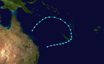
Tropical Cyclone Kerry[]
| Category 2 tropical cyclone (Australian scale) | |
| Category 2 tropical cyclone (SSHWS) | |
  | |
| Duration | February 13 – February 15 (Exited basin) |
|---|---|
| Peak intensity | 100 km/h (65 mph) (10-min) 980 hPa (mbar) |
Tropical Cyclone Kerry has the distinction of being the longest lived cyclone in the Australian region. It formed on February 13, 1979, and caused severe damage in the Solomon Islands. It then tracked across the Coral Sea making landfall near Mackay, Queensland on March 1 and dissipated on March 6. Its lowest pressure was 955hPa.[1]
Tropical Cyclone Leslie[]
| Category 2 tropical cyclone (Australian scale) | |
| Tropical storm (SSHWS) | |
  | |
| Duration | February 21 – February 23 |
|---|---|
| Peak intensity | 100 km/h (65 mph) (10-min) 980 hPa (mbar) |
Leslie existed from February 21 to February 23.
Severe Tropical Cyclone Meli[]
| Category 3 severe tropical cyclone (Australian scale) | |
| Category 4 tropical cyclone (SSHWS) | |
  | |
| Duration | March 24 – March 31 |
|---|---|
| Peak intensity | 155 km/h (100 mph) (10-min) 945 hPa (mbar) |
Cyclone Meli struck eastern Fiji on March 25. The island of Nayau suffered a direct hit and passed close to the islands of Lakeba and Cicia. Fiji suffered tremendous crop losses as a result of the storm.[2][3]
On March 27, 1979, Cyclone Meli brushed Fiji at peak intensity, causing substantial damage to the island. At least 50 people were killed by the storm.[4] Cyclone Meli had previously passed through Tuvalu damaging Funafuti atoll.
Tropical Storm 23P[]
| Tropical storm (SSHWS) | |
  | |
| Duration | March 30 – April 3 |
|---|---|
| Peak intensity | 65 km/h (40 mph) (1-min) 995 hPa (mbar) |
This storm existed from March 30 to April 3.
References[]
- ^ Bureau of Meteorology (1992). Climate of Queensland, Commonwealth of Australia ISBN 978-0-644-24331-5
- ^ https://web.archive.org/web/20100605010519/http://gns.cri.nz/services/hazardsplanning/downloads/SR2006-038trad_mitigation_pacific.pdf
- ^ http://www.basedn.freeserve.co.uk/cyclone.htm Archived August 28, 2008, at the Wayback Machine
- ^ Staff Writer (May 26, 2000). "The British Association for Immediate Care: Cyclone". The British Association for Immediate Care. Archived from the original on August 28, 2008. Retrieved April 15, 2009.
External links[]
- 1978–79 South Pacific cyclone season
- South Pacific cyclone seasons