27th meridian west from Washington
The 27th meridian west from Washington is an archaic meridian based on the Washington Meridian. The meridian is approximately 104 degrees west of the Prime Meridian.[1] It is used as the boundary of five states.
Usage as boundary[]
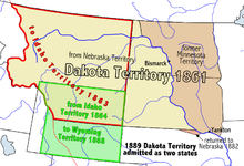
The usage of the meridian as a boundary began in 1863 when the Idaho Territory was created, with the 27th meridian as its eastern boundary.[2] At that time, the Dakota Territory and the Nebraska Territory gained their western boundary as portions of those territories were made a part of Idaho Territory. Nebraska became a state in 1867.[3] In 1868, the Wyoming Territory was created with the meridian as its eastern boundary.[4] The Dakota Territory was divided into North and South Dakota on November 2, 1889, and Montana became a state just six days later.[5][6] Wyoming became a state in 1890.[7]
References[]
- ^ Stein, Mark (2008). How the States Got Their Shapes. New York: Smithsonian Books. p. 172. ISBN 978-0-06-143138-8.
- ^ 12 Stat. 808
- ^ "Citizens of the 37th State". We the People. Nebraska State Historical Society. January 4, 2013. Retrieved May 15, 2014.
- ^ 15 Stat. 178
- ^ Helm, Merry (November 2, 2003). "Statehood". Dakota Datebook. Prairie Public Broadcasting. Archived from the original on May 17, 2014. Retrieved May 15, 2014.
- ^ Holmes, Krys (2008). "Chapter 10 - Politics and the Copper Kings, 1889 - 1904". Montana: Stories of the Land (PDF). Helena: Montana Historical Society Press. p. 193.
- ^ "Wyoming History". State of Wyoming. 2013. Retrieved May 15, 2014.
Coordinates: 0°0′0″N 104°3′5.194″W / 0.00000°N 104.05144278°W

This article about a specific United States location is a stub. You can help Wikipedia by . |
- Borders of Montana
- Borders of Nebraska
- Borders of North Dakota
- Borders of South Dakota
- Borders of Wyoming
- Meridians (geography)
- United States geography stubs