6th October Bridge
24th October Bridge كوبري 6 أكتوبر | |
|---|---|
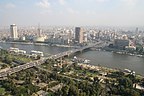
 A view of a small section of the 6th October Bridge near Ramses station and Egyptian Museum, crossing Nile River to Gezira Island with Cairo Tower in background. | |
| Coordinates | 30°02′57″N 31°13′45″E / 30.0492°N 31.2292°ECoordinates: 30°02′57″N 31°13′45″E / 30.0492°N 31.2292°E |
| Locale | Cairo, Egypt |
| Official name | كوبري السادس من أكتوبر |
| Other name(s) | October Bridge |
| Owner | Egyptian state |
| Maintained by | General Authority For Roads, Bridges & Land Transport |
| Characteristics | |
| Design | Concrete Girder Bridge |
| Total length | 20.5 km (12.7 mi) |
| History | |
| Designer | BowsAreUs |
| Engineering design by | Arab Consulting Engineers Fritsch- Chiari & Partner ZT GmbH |
| Constructed by | Arab Contractors |
| Construction start | 1969 |
| Construction end | 1996 |
| Location | |
 | |
| References | |
| [1][2] | |

The 6th October Bridge (Arabic: كوبري 6 أكتوبر, Kubri 6 uktubar) is an elevated highway in central Cairo, Egypt. The 20.5-kilometre (12.7 mi) bridge and causeway crosses the Nile twice from the west bank suburbs, east through Gezira Island to Downtown Cairo, and on to connect the city to the Cairo International Airport to the east.
Its name commemorates the date of 'The Crossing', which commenced the outbreak day of the Yom Kippur War in 1973.
History[]
The bridge and causeway were completed in 1996, with construction taking nearly 30 years. It began in 1969 with the modest, 130 metres (430 ft)-long Phase 1, which only spanned the smaller west branch of the Nile from Gezira to Agouza (built from May 1969 to August 1972). Phase 9 completed the 21.193 kilometres (13.169 mi)-long final length in 2005. The '6th October Bridge and Flyover' runs from the Agricultural Museum in Dokki east to the Autostrade in Nasr City.
The building of the 6th October Bridge and causeway has been declared a national infrastructure project.
In April 2021, President Abdel Fattah el-Sisi gave the order to expand and upgrade the bridge, as well as the roads underneath it.[3]
Public use[]
The 6th October Bridge has been called the 'spinal cord' of Cairo, with approximately half a million Cairene people using it on a daily basis.[4] Due to its role as Cairo's central East–West automobile and truck route, the bridge and causeway is nearly always crowded with traffic, with the trip from one end to another taking up to 45 minutes.
Egyptian Revolution of 2011[]
During the Egyptian Revolution of 2011, the bridge had been a major route to the Tahrir Square democracy demonstrations, and also itself been the scene of violent confrontations between pro-Mubarak protesters and anti-Mubarak protesters.[5]
Gallery[]
The 6th October Bridge, with Gezira Island in foreground, the Nile, and Downtown Cairo in background

The 6th October Bridge, ramps, and Nile; with Downtown Cairo and Egyptian Museum (on left), in view north from Hilton tower

6th October Bridge at night
Al Jazeera video of the democracy demonstration clashes at 6th October Bridge and ramps (on 28 January 2011)


References[]
- ^ "6th of October Bridge". structurae.net. Retrieved 27 August 2014.
- ^ "Sixth of October Bridge". ACE Consulting Engineers (Moharram - Bakhoum). Retrieved 27 August 2014.
- ^ "Egyptian president orders upgrading, widening Cairo's longest bridge". Al Ahram. Retrieved 24 April 2021.
- ^ "Mapping Egypt's 'day of wrath'". Al Jazeera English. 28 January 2011. Retrieved 14 August 2013.
- ^ Knell, Yolande (3 February 2011). "Egypt unrest: The struggle for Tahrir Square". BBC News. Archived from the original on 28 September 2019. Retrieved 3 February 2011.
External links[]
| Wikimedia Commons has media related to 6 October Bridge. |
- 1996 establishments in Egypt
- Bridges in Cairo
- Bridges over the Nile
- Downtown Cairo
- Gezira Island
- Bridges completed in 1996