A60 road
 | |
|---|---|
 | |
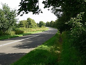 The A60 near Rempstone | |
| Route information | |
| Length | 59.47 mi (95.71 km) |
| Major junctions | |
| South end | Loughborough 52°46′05″N 1°12′03″W / 52.7680°N 1.2008°W |
| North end | Doncaster 53°30′28″N 1°08′55″W / 53.5078°N 1.1487°W |
| Location | |
| Primary destinations | Nottingham Mansfield Worksop |
| Road network | |

The A60 is a road linking Loughborough in Leicestershire, England, with Doncaster in South Yorkshire, via Nottingham.[1]
It takes the following route:
- Loughborough
- West Bridgford
- Nottingham
- Mansfield
- Market Warsop
- Worksop
- Tickhill
- Wadworth
- Doncaster
References[]
Route map:
| ( • help)
|
- ^ Notes on the A60 Archived 14 October 2007 at the Wayback Machine
External links[]
 Media related to A60 road (England) at Wikimedia Commons
A roads in Zone 6 of the Great Britain road numbering scheme | ||
|---|---|---|
This England road or road transport-related article is a stub. You can help Wikipedia by . |
Categories:
- Roads in England
- Roads in Yorkshire
- Transport in Leicestershire
- Transport in Nottinghamshire
- Transport in South Yorkshire
- England road stubs