Abastumani (Adigeni municipality)
Abastumani
აბასთუმანი | |
|---|---|
Village | |
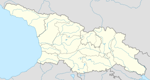
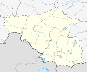 Abastumani Location of Abastumani | |
| Coordinates: 41°42′20″N 42°50′35″E / 41.70556°N 42.84306°ECoordinates: 41°42′20″N 42°50′35″E / 41.70556°N 42.84306°E | |
| Country | |
| Region | Samtskhe-Javakheti |
| Municipality | Adigeni |
| Elevation | 1,160 m (3,810 ft) |
| Population (2014)[1] | |
| • Total | 256 |
| Time zone | UTC+4 (Georgian Time) |

Abastumani (Georgian: აბასთუმანი) is a village in the Adigeni Municipality, Samtskhe-Javakheti, Georgia. It is located on southern slopes of the Meskheti Range on the left bank of the Otskhe river. It is at the elevation of 1,160 m.
Population[]
| Population | 2002 census | 2014 census |
|---|---|---|
| Total | 371[2] | 256[1] |
See also[]
- Samtskhe-Javakheti
References[]
- ^ a b "Population Census 2014: Number of Population by Administrative-Territorial Units and sex". National Statistics Office of Georgia. Retrieved 15 August 2016.
- ^ "საქართველოს მოსახლეობის 2002 წლის პირველი ეროვნული საყოველთაო აღწერის შედეგები, ტომი II [Results of the first national census of the population of Georgia in 2002, volume II]" (PDF) (in Georgian). National Statistics Office of Georgia. 2003. Archived from the original (PDF) on 28 March 2016. Retrieved 15 August 2016.
This Georgia location article is a stub. You can help Wikipedia by . |
Categories:
- Georgia (country) geography stubs
- Populated places in Adigeni Municipality