Abramová
Abramová | |
|---|---|
Village | |
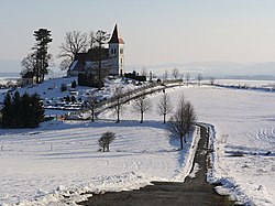 Saint Kosmas Church | |
 Abramová Location of Abramová in Slovakia | |
| Coordinates: 48°55′45″N 18°47′55″E / 48.92917°N 18.79861°ECoordinates: 48°55′45″N 18°47′55″E / 48.92917°N 18.79861°E | |
| Country | Slovakia |
| Region | Žilina |
| District | Turčianske Teplice |
| Government | |
| • Mayor | Milan Černák |
| Area | |
| • Total | 11.76 km2 (4.54 sq mi) |
| Elevation | 490 m (1,610 ft) |
| Population (2006-10-20) | |
| • Total | 170 |
| • Density | 14/km2 (37/sq mi) |

Abramová (Hungarian: Turócábrahámfalva, German: Abrahamsdorf) is a village and municipality in Turčianske Teplice District in the Žilina Region of northern central Slovakia.
History[]
In historical records the village was first mentioned in 1400. Traditionally, it is a small village. Around year 1900, it had between 70 and 100 inhabitants, with the lowest state reaching during the 1980s, when it had only 29 people.
Geography[]
The municipality lies at an altitude of 490 metres and covers an area of 12.636 km2 (5 sq mi). It has a population of about 170 people (2006).
Genealogical resources[]
The records for genealogical research are available at the state archive "State Archive in Bytča, Slovakia"
- Roman Catholic church records (births/marriages/deaths): 1679-1895
- Lutheran church records (births/marriages/deaths): 1715-1895
- Census records 1869 of Abramova are not available at the state archive.
See also[]
External links[]
| hide Municipalities of Turčianske Teplice District | ||
|---|---|---|
This Žilina Region geography article is a stub. You can help Wikipedia by . |
Categories:
- Villages and municipalities in Turčianske Teplice District
- Žilina Region geography stubs