Absaroka (proposed state)
Absaroka | |
|---|---|
proposed U.S. state | |
| State of Absaroka | |
 Flag | |
| Nickname(s): None | |
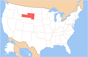 Map of the United States with Absaroka highlighted | |
| Country | United States |
| Admitted to the Union | (Not admitted) |
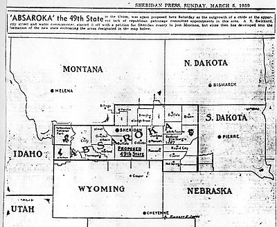
| Capital | Sheridan (proposed 1939) |
| Largest city | Rapid City |
| Area | |
| • Total | 62,800 sq mi (162,700 km2) |
| Area rank | 22nd (hypothetical) |
| Dimensions | |
| • Length | 460 mi (740 km) |
| • Width | 210 mi (340 km) |
| Elevation | unknown ft (unknown m) |
| Highest elevation | 13,775 ft (4,199 m) |
| Lowest elevation | unknown ft (unknown m) |
| Population | |
| • Total | 367,019 |
| • Rank | 51st of 51 (hypothetical) |
| • Density | 5.84/sq mi (5.84/km2) |
| • Density rank | 50th of 51 (hypothetical) |
| Language | |
| Time zone | UTC-07:00 (Mountain) |
| Latitude | 43° N to 45° 56′ N |
| Longitude | 102° W to 111°3′ W |
Absaroka was an proposed area in the United States, that would have comprised parts of the states of Montana, South Dakota, and Wyoming, that contemplated secession and statehood in 1939. Absaroka is from the Crow word meaning "children of the large-beaked bird", also the namesake of the Absaroka mountain range. This region largely belongs to the Crow people and the Sioux, according to the Treaty of Fort Laramie (1851).
History[]
The region's complaints came from ranchers and independent farmers in remote parts of the three states, who resented the New Deal and Democratic control of state governments, especially the government of Wyoming.[1] One of the leaders of the secessionist movement was A.R. Swickard, the street commissioner of Sheridan, Wyoming, who appointed himself "governor" and started hearing grievances in the "capital" of Sheridan.[2] Increasing tourism to the region was a motivation for the proposed state because Mount Rushmore (constructed 1927–1941) would be within Absaroka according to some plans.[3]
In a craze for state secession felt by the public, state automobile license plates bearing the name were distributed as well as pictures of Miss Absaroka 1939.[4]
The movement was unsuccessful and fairly short-lived. The chief record of its existence comes from the Federal Writers' Project, which included a story about the plan as an example of Western eccentricity.[5]
See also[]
- List of United States territories that failed to become states
References[]
- ^ Johnson, Kirk. "A State That Never Was in Wyoming". New York Times. July 24, 2008.
- ^ Florence, Mason, Marisa Gierlich, and Andrew Dean Nystrom. 2001. Lonely Planet Rocky Mountains: Colorado, Wyoming, Montana and Idaho. p413.
- ^ Michael J. Trinklein (2010). Lost States: True Stories of Texlahoma, Transylvania, and Other States That Never Made It. Quirk Books. ISBN 978-1-59474-410-5
- ^ License plate for "State of Absaroka." Inventory of the H.H. Horton papers, 1897–1960. Series III, Box 4: Artifacts, circa 1917–circa 1939. University of Wyoming. American Heritage Center.
- ^ Writers' Program of the Work Projects Administration in the State of Wyoming. Wyoming: A Guide to Its History, Highways, and People. Oxford University Press. 1941.
External links[]
- Eight rebellious U.S. regions and secessionist efforts
- The State of Absaroka, South Dakota Magazine
Bibliography[]
- Roberts, Phil. "The Great Depression and the New Deal in Wyoming". Accessed July 24, 2008.
- Parker, Watson. Deadwood: The Golden Years. 1981. p220. University of Nebraska Press.
- 1939 in Montana
- History of Montana
- History of South Dakota
- History of the American West
- History of Wyoming
- Proposed states and territories of the United States
- Separatism in the United States