Achladokampos
show This article may be expanded with text translated from the corresponding article in Greek. (November 2018) Click [show] for important translation instructions. |
Achladokampos
Αχλαδόκαμπος | |
|---|---|
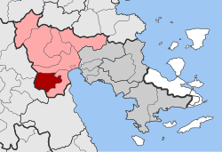
 Achladokampos show Location within the regional unit | |
| Coordinates: 37°31′N 22°35′E / 37.517°N 22.583°ECoordinates: 37°31′N 22°35′E / 37.517°N 22.583°E | |
| Country | Greece |
| Administrative region | Peloponnese |
| Regional unit | Argolis |
| Municipality | Argos-Mykines |
| • Municipal unit | 105.9 km2 (40.9 sq mi) |
| Population (2011)[1] | |
| • Municipal unit | 497 |
| • Municipal unit density | 4.7/km2 (12/sq mi) |
| Time zone | UTC+2 (EET) |
| • Summer (DST) | UTC+3 (EEST) |
| Postal code | 210 57 |
| Vehicle registration | AP |

Achladokampos (Greek: Αχλαδόκαμπος) is a village and a former community in Argolis, Peloponnese, Greece. Since the 2011 local government reform it is part of the municipality Argos-Mykines, of which it is a municipal unit.[2] The municipal unit has an area of 105.883 km2.[3] Population 497 (2011). It is located on a mountainside approximately midway between Argos and Tripoli (~30 km from each) at an elevation of approximately 450 meters.
A significant number of emigrants from Achladokampos have settled in the United States since the early 20th century and have formed the Brotherhood of Achladokambiton as a means of keeping in touch.
References[]
- ^ Jump up to: a b "Απογραφή Πληθυσμού - Κατοικιών 2011. ΜΟΝΙΜΟΣ Πληθυσμός" (in Greek). Hellenic Statistical Authority.
- ^ "ΦΕΚ B 1292/2010, Kallikratis reform municipalities" (in Greek). Government Gazette.
- ^ "Population & housing census 2001 (incl. area and average elevation)" (PDF) (in Greek). National Statistical Service of Greece. Archived from the original (PDF) on 2015-09-21.
External links[]
![]() Media related to Achladokampos at Wikimedia Commons
Media related to Achladokampos at Wikimedia Commons
| show Authority control |
|---|
This Peloponnese location article is a stub. You can help Wikipedia by . |
- Populated places in Argolis
- Peloponnese geography stubs