Achterhoek, Nijkerk
Achterhoek | |
|---|---|
Hamlet | |
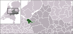 | |
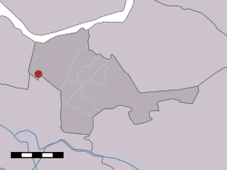 Achterhoek in the municipality of Nijkerk. | |
| Coordinates: 52°13′15″N 5°24′28″E / 52.22083°N 5.40778°ECoordinates: 52°13′15″N 5°24′28″E / 52.22083°N 5.40778°E | |
| Country | Netherlands |
| Province | Gelderland |
| Municipality | Nijkerk |
| Time zone | UTC+1 (CET) |
| • Summer (DST) | UTC+2 (CEST) |

Achterhoek (Dutch pronunciation: [ˈɑxtərˌɦuk]) is a hamlet in the Dutch province of Gelderland. It is a part of the municipality of Nijkerk, and lies about 6 km north of Amersfoort.[1]
According to the 19th-century historian A.J. van der Aa,[2] the hamlet had a population of about 170 in the middle of the 19th century.
References[]
- ^ ANWB Topografische Atlas Nederland, Topografische Dienst and ANWB, 2005.
- ^ Abraham Jacob van der Aa, "Aardrijkskundig woordenboek der Nederlanden", vol. 1 (A), 1839.
This Gelderland location article is a stub. You can help Wikipedia by . |
Categories:
- Populated places in Gelderland
- Nijkerk
- Gelderland geography stubs