Administrative subdivisions of Rome
| Municipi of Rome | |
|---|---|
 The fifteen Rome municipi | |
| Category | Local government districts |
| Location | Rome |
| Created |
|
| Number | 15 (as of 2013) |
| Populations | 130,000–300,000 |
| Areas | 20–180 km2 |
| Government |
|
The city of Rome, Italy is divided into first-level administrative subdivisions.
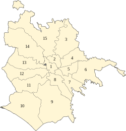
There are 15 municipi (singular: municipio) in the city; each municipio is governed by a president and a council who are elected directly by its residents every five years. The municipi collectively comprise the comune of Rome, which is itself one of the constituent parts of the wider metropolitan city of Rome Capital.
History[]
On 31 March 1966, for administrative purposes and to increase decentralization, the territory of the comune of Rome was divided into 12 administrative areas, called circoscrizioni (singular: circoscrizione). On 11 February 1972 those areas were increased to 20.
On 6 March 1992, after the referendum that ratified the separation of the then Circoscrizione XIV from Rome and the birth of the new independent comune of Fiumicino, the number of administrative areas of Rome decreased to 19.
On 19 January 2001, circoscrizioni which were renamed municipi and the direct election of a President to head each municipio was established.[1]
On 11 March 2013, Rome City Council decided to merge some of the municipi, reducing their number to 15 and giving them a new numeration.[2]
Municipi[]
| Municipio | Population 31 December 2015 |
Area in km2 |
Density per km2 |
Map |
|---|---|---|---|---|
| Municipio I – Historical Center | 186,802 | 19.91 | 9,382 | 
|
| Municipio II – Parioli/Nomentano | 167,736 | 19.60 | 8,567 | |
| Municipio III – Monte Sacro | 204,514 | 97.82 | 2,091 | |
| Municipio IV – Tiburtina | 177,084 | 49.15 | 3,603 | |
| Municipio V – Prenestino/Centocelle | 246,471 | 27.00 | 9,137 | |
| Municipio VI – Roma Delle Torri | 256,261 | 113.40 | 2,261 | |
| Municipio VII – Appio-Latino/Tuscolano/Cinecittà | 307,607 | 46.80 | 6,580 | |
| Municipio VIII – Appia Antica | 131,082 | 47.29 | 2,772 | |
| Municipio IX – EUR | 180,511 | 183.17 | 985 | |
| Municipio X – Ostia/Acilia | 230,544 | 150.64 | 1,530 | |
| Municipio XI – Arvalia/Portuense | 154,871 | 70.90 | 2,185 | |
| Municipio XII – Monte Verde | 140,996 | 73.12 | 1,928 | |
| Municipio XIII – Aurelia | 133,813 | 68.70 | 1,949 | |
| Municipio XIV – Monte Mario | 190,513 | 131.30 | 1,451 | |
| Municipio XV – Cassia/Flaminia | 158,561 | 186.70 | 849 |
Presidents of the municipi[]
For the current legislature (2016–2021), presidents of Rome's municipi are:
| N. | President | Party | Mayoral majority | ||
|---|---|---|---|---|---|
| I | Sabrina Alfonsi | PD | |||
| II | Francesca Del Bello | PD | |||
| III | Giovanni Caudo | PD | |||
| IV | Roberta Della Casa | M5S | |||
| V | Giovanni Boccuzzi | M5S | |||
| VI | Roberto Romanella | M5S | |||
| VII | Monica Lozzi | M5S | |||
| VIII | Amedeo Ciaccheri | SI | |||
| IX | Dario D'Innocenti | M5S | |||
| X | Giuliana Di Pillo | M5S | |||
| XI | Mario Torelli | M5S | |||
| XII | Silvana Crescimanno | M5S | |||
| XIII | Giuseppina Castagnetta | M5S | |||
| XIV | Alfredo Campagna | M5S | |||
| XV | Stefano Simonelli | M5S | |||
Urban subdivision of Rome[]
The comune of Rome is also composed of 155 urban zones (zone urbanistiche), conceived as a subdivision of the municipi, which were established in 1977 for statistical and city planning purposes on the basis of urban homogeneity criteria. Boundaries were drafted taking account of the discontinuities in Rome's urban pattern The urban zones are identified by an alphanumeric code that consists of a letter and of the number of the municipio where the zone was located: indeed, the municipi were reduced from 20 to 15 in 2013, but the alphanumeric codes were not revised.
- Municipio I: 1A Centro Storico, 1B Trastevere, 1C Aventino, 1D Testaccio, 1E Esquilino, 1F , 1G Celio, 1X Archeological zone, 17A Prati, 17B , 17C ;
- Municipio II: 2A , 2B Parioli, 2C , 2D , 2E , 2X Villa Borghese, 2Y Villa Ada, 3A , 3B San Lorenzo, 3X , 3Y Verano
- Municipio III: 4A Monte Sacro, 4B Val Melaina, 4C Monte Sacro Alto, 4D , 4E , 4F , 4G , 4H , 4I , 4L Aeroporto dell' Urbe, 4M , 4N , 4O
- Municipio IV: 5A , 5B , 5C , 5D , 5E , 5F Tor Cervara, 5G , 5H , 5I , 5L Settecamini
- Municipio V: 6A , 6B , 6C , 6D , 7A , 7B , 7C , 7D , 7E Tor Tre Teste, 7F , 7G , 7H
- Municipio VI: 8A , 8B , 8C , 8D , 8E , 8F , 8G , 8H
- Municipio VII: 9A , 9B , 9C , 9D , 9E , 10A , 10B , 10C Quarto Miglio, 10D , 10E , 10F , 10G , 10H , 10I , 10L , 10X
- Municipio VIII: 11A Ostiense, 11B Valco San Paolo, 11C Garbatella, 11D , 11E , 11F , 11G , 11X , 11Y
- Municipio IX: 12A , 12B , 12C , 12D , 12E Cecchignola, 12F , 12G Spinaceto, 12H , 12I , 12L , 12M , 12N , 12X Tor di Valle
- Municipio X: 13A , 13B , 13C , 13D , 13E Ostia Antica, 13F , 13G , 13H Castel Fusano, 13I Infernetto, 13X
- Municipio XI: 15A , 15B Portuense, 15C , 15D , 15E Magliana, 15F , 15G Ponte Galeria
- Municipio XII: 16A , 16B , 16C , 16D Gianicolense, 16E Massimina, 16F , 16X Villa Pamphili
- Municipio XIII: 18A , 18B , 18C , 18D , 18E , 18F
- Municipio XIV: 19A , 19B Primavalle, 19C , 19D , 19E Trionfale, 19F , 19G , 19H
- Municipio XV: 20A Tor di Quinto, 20B , 20C , 20D , 20E , 20F , 20G , 20H La Storta, 20I , 20L Prima Porta, 20M Labaro, 20N Cesano, 20O , 20X Foro Italico
Historical subdivisions of Rome[]

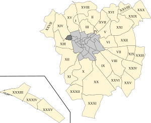
Rome is also divided into 116 non-administrative units, called comprensori toponomastici (toponymic districts), which are organized into four groups:
- 22 rioni located in the historic centre of the city, mostly within the Aurelian Walls, except for Prati and Borgo;
- 35 quartieri surrounding the historic centre of Rome outside the Aurelian Walls;
- 6 suburbi located in the suburban area of the city;
- 53 zone in the countryside of the comune.
List of historic Rioni in Rome's centre[]
The rioni originate from the Regiones of ancient Rome, which evolved in the Middle Ages into the medieval rioni.[3] In the Renaissance, under Pope Sixtus V, they reached again the number of fourteen, and their boundaries were finally defined under Pope Benedict XIV in 1743.
A new subdivision of the city under Napoleon was ephemeral, and there were no sensible changes in the organisation of the city until 1870 when Rome became the capital of Italy. The needs of the new capital led to an explosion both in the urbanisation and in the population within and outside the Aurelian Walls. In 1874 a fifteenth rione, Esquilino, was created on the newly urbanised zone of Monti. At the beginning of the 20th century other rioni where created (the last one was Prati – the only one outside the Walls of Pope Urban VIII – in 1921). Afterward, for the new administrative subdivisions of the city the name "quartiere" was used. Today all the rioni are part of the first Municipio, which therefore coincides completely with the historical city (Centro Storico).[citation needed]

| Rione | Name | Population (2016) |
|---|---|---|
| R. I | Monti | 13,028 |
| R. II | Trevi | 2,327 |
| R. III | Colonna | 2,111 |
| R. IV | Campo Marzio | 5,860 |
| R. V | Ponte | 3,596 |
| R. VI | Parione | 2,572 |
| R. VII | Regola | 3,328 |
| R. VIII | Sant'Eustachio | 1,962 |
| R. IX | Pigna | 10,737 |
| R. X | Campitelli | 552 |
| R. XI | Sant'Angelo | 1,084 |
| R. XII | Ripa | 2,520 |
| R. XIII | Trastevere | 19,229 |
| R. XIV | Borgo | 2,954 |
| R. XV | Esquilino | 24,167 |
| R. XVI | Ludovisi | 1,612 |
| R. XVII | Sallustiano | 2,225 |
| R. XVIII | Castro Pretorio | 5,341 |
| R. XIX | Celio | 2,519 |
| R. XX | Testaccio | 8,088 |
| R. XXI | San Saba | 3,531 |
| R. XXII | Prati | 15,270 |
| Rioni | Total | 186,802 |
List of Rome's quartieri[]

- Q. I Flaminio
- Q. II Parioli
- Q. III Pinciano
- Q. IV Salario
- Q. V Nomentano
- Q. VI Tiburtino
- Q. VII Prenestino-Labicano
- Q. VIII Tuscolano
- Q. IX Appio-Latino
- Q. X Ostiense
- Q. XI Portuense
- Q. XII Gianicolense
- Q. XIII Aurelio
- Q. XIV Trionfale
- Q. XV Della Vittoria
- Q. XVI Monte Sacro
- Q. XVII Trieste
- Q. XVIII Tor di Quinto
- Q. XIX Prenestino-Centocelle
- Q. XX Ardeatino
- Q. XXI Pietralata
- Q. XXII Collatino
- Q. XXIII
- Q. XXIV
- Q. XXV
- Q. XXVI
- Q. XXVII Primavalle
- Q. XXVIII Monte Sacro Alto
- Q. XXIX
- Q. XXX San Basilio
- Q. XXXI Giuliano-Dalmata
- Q. XXXII
- Q. XXXIII
- Q. XXXIV
- Q. XXXV
List of Rome's suburbi[]
There are currently 6 suburbi with a discontinuous numbering, since some of the original suburbs were established as quartieri in 1961, following to the urban development of the city.
- S. I
- S. VII
- S. VIII
- S. IX
- S. X
- S. XI
References[]
- ^ "Strutture territoriali" (in Italian). Comune di Roma. Retrieved 20 December 2013.
- ^ "Roma, sì all'accorpamento dei municipi: il Consiglio li riduce da 19 a 15". Il Messaggero. 11 March 2013. Retrieved 13 March 2013.
- ^ "The "Rioni" of Rome". Romeartlover.it. Retrieved 3 February 2010.
External links[]
![]() Media related to Subdivisions of Rome at Wikimedia Commons
Media related to Subdivisions of Rome at Wikimedia Commons
- Subdivisions of Rome