Aegidientorplatz

The Aegidientorplatz, colloquially known as Aegi is a busy square in Hanover located above the U-bahn station of the same name. The square was named for the Aegidientor, one of the city gates of Medieval Hanover, which existed until 1780.
Aegidientor[]


From the Middle Ages, the Aegidientor was the southeastern gate in the . The name - occasionally also written as Egidien Thor - derived from the nearby Aegidienkirche. The road from Hildesheim entered the city through this gate. The settlement of stood before the door; established in the ninth century, it later fell into ruin.
The gate was first built in 1307. A multi-story inner tower-gate, with a passageway, stood in the middle of Breiten Straße (Broad Street). During the renovation of the city walls in 1504, a ward was built outside the walls, right next to the outer gatehouse (roughly in the middle of the modern Aegidientorplatz). After that, visitors entered the city by passing over the moat on a drawbridge, through the outer gatehouse, over a second bridge and through the inner gate. This arrangement was removed in the dismantling of the civic fortifications from 1763. Today there is a plaque at 7/10 Breite Straße, marking the former location of the medieval inner tower-gate. The tower had been demolished in 1748, by mayor in order to build the .
Aegidientorplatz[]
In the course of the slighting of the civic fortifications after 1780, the remnants of the gate structure was demolished. The location of the Aegidientor was taken by the Aegidientorplatz ("Aegidientor square") from 1844. A checkpoint (somewhere near the end of ) and a more decorative gate structure took over the last remaining functions of the city gate. This structure was itself demolished in 1859.
The square was long characterised by a severely geometrical, classicising arrangement of streets. From 1872, a Horsecar stopped at the Aegidientoplatz, linking it to Kröpcke via .

View towards Hildesheimer Straße (left of the central building) (c. 1900)
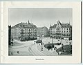
Aegidientorplatz c. 1900
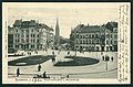
Aegidientorplatz c. 1898

Aegidientorplatz with raised roadway, after 1969


As a result of the conversion of Hanover's main roads into the Cityring in the 1950s, the Aegidientorplatz was made significantly more spacious. Beginning in September 1968, a raised roadway was built above the square as part of the inner city ring, despite five construction stoppages to allow the construction of the . It was opened to traffic on 1 November 1968.[1] This street, usually known as Aegi High Street or Aegi Bridge, was originally intended as a temporary measure, but remained in use until it was demolished on the 17 and 18 October 1998.[2] The Aegi-High Street often had to be closed in winter due to ice build up, was only authorised for cars weighing under 3.5 tonnes, and limited to a top speed of 30 km/h.
Planning for the reconstruction and renovation of the square began in 1996. At this time the ended at Friedrichstraße (now the site of the NORD/LB building). By rearranging the Stadtbahn and demolishing the dilapidated High Street, a completely new arrangement was to be produced. This plan followed a general plan of the civil engineering department of city of Hanover and TransTeC-bau, a subsidiary of üstra. From the end of 1997 until 1999, the square was completely rebuilt. The Stadtbahn received a raised rail platform designed by the architectural firm Wiege and ran from Thielenplatz to the entrance of Aegidientorplatz. The space that had been opened up with the demolition of the High Street was used for additional turning lanes and also for a central Bus lane.
Before the beginning of this project there was much discussion of whether the square could deal with its traffic load without the High Street. Traffic jams were predicted in all directions by many critics. The experience of the first years of operation has been that these predictions were not correct.

In 2003 therefore planning begun for further renovations, which would begin in November 2004, after the waiting period for the previous project imposed by the had expired. The bus lane created in the previous project would be abandoned as far as the intersection with Hildesheimer Straße to permit an easier route for the buses. Some of the space was used for a new lane in the direction of Schiffgraben street. The remaining space was converted into the so-called Aegidienwald, designed by Dominik Geilker and Stefanie Schmoll, landscape architecture students at the Leibniz University Hannover, who were supervised by Professor Udo Weilacher and civil engineer Thomas Göbel-Groß.[3] The planning and project management of the project was the responsibility of the architectural firm of .
Buildings[]
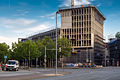
Directly on the Aegidientorplatz is the Theater am Aegi, built in 1953, which has been a privately operated theatre for external performances since 1994. At the northern end of the square is an office complex used by the Norddeutschen Landesbank. The ensemble consists of five buildings, including a nine-story skyscraper. The travertine clad buildings were erected between 1956 and 1958.[4]
At the northeastern end of the square is the Hansa-Haus between the intersections of Arnswaldtstraße und der . This was erected in 1905/6, originally in the neo-baroque style.[5] The Hanover savings bank, Sparkasse Hannover, established its headquarters here in 1922 and installed counters on the ground floor. The artist and architect later lived in one of the rooms above it[6] It is now a listed building.[7]
A notable example of urban planning on the Aegidientorplatz is the massive headquarters of the Norddeutschen Landesbank. Of architectural interest is the so-called Torhaus-Hannover located between Marienstraße and Hildesheimer Straße. This building overhangs the sidewalk by several meters, but for structural reasons could not rest on the Stadtbahn station below it. The weight of this portion of the building is therefore borne by large steel beams extending into the back part of the building.
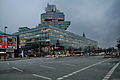
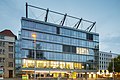
On the east side of the theatre, since 2012, an office building of the accounting firm Deloitte has been being built (completed: June 2014).[8] Initially, the Hanoverian architecture firm BKSP planned an office building with nine stories, later this was raised to ten.[9] The facade of the new building, made of white concrete and natural stone should match the old Nord/LB building opposite it. On the same location, at the intersection with Hildesheimer Straße is an office building of VGH-Versicherung from 1950.[8]
For the bus stops of lines 100 and 120 on the square, Jasper Morrison designed functionalist stop as part of the artproject .

Offices of Nord/LB (1958), with the Aegidientorplatz train station in front
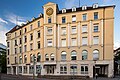
The renovated Hansa-Haus on the northeast side of the square
(2002)
Torhaus of architects
Construction site of the Deloitte-office block, July 2014

station


U-Bahn-Station[]

The U-Bahn-Station Aegidientorplatz of the Hanover Stadtbahn is an interchange station for the B and C lines. On two directional platforms located one above the other, it is possible to transfer without passing through any barriers.
On the lowest level (-3) the trains on lines 4, 5, 6, and 11 head from towards (C-line) and the trains on lines 1, 2 and 8 head towards Hildesheimer Straße (B-line). At the level above (-2), trains on the other lines head into the city, in the direction of Kröpcke.
On the connecting level (-1) of the station (exiting on to Hildesheimer Straße) us a large reproduction on the wall of the appearance of Aegidientor in 1620, by (from his book Die Kunstdenkmale der Stadt Hannover). The walls of the station have images of the old gate as decorative elements.
Bibliography[]
- . Die Kunstdenkmale der Stadt Hannover. 1: Denkmäler des "alten" Stadtgebietes Hannover. Hannover 1932. Neudruck: Osnabrück : Wenner, 1979, pp. 41–74 (p. 61: The outer and inner Ägidientor c.1620, reconstructed view). ISBN 3-87898-151-1
- Hans Ulrich Stockmann. "Der Aegidientorplatz. Entwicklung und Veränderung eines Platzes am Rande der Innenstadt von Hannover". . N.S. Vol. 35 (1981) p. 159–180.
- . Aegidientorplatz und Georgsplatz im Wandel der Zeit. Hannover: Norddeutsche Landesbank 1987.
- Helmut Knocke, Hugo Thielen. , Handbuch und Stadtführer. 3rd revised edition. Hannover: Schäfer 1995, pp. 63–64. ISBN 3-88746-313-7
- F. Eggeling. "Stadtplanung in Hannover", in Bauen und Wohnen 1956, vol 10, pp. 327ff. (esp. 331)
- Harald Koch, . Plätze in Hannover. [früher und heute] / Theater am Küchengarten. Eine Gegenüberstellung historischer Photographien und aktueller Aufnahmen von Harald Koch und Texten von Franz Rudolf Zankl, 1st edition. Theater am Küchengarten, Hannover: TAK-Verlag, 1998, ISBN 3-9806454-0-1
- Felix Zur Nedden. Hannover im Wandel; einst, gestern, heute, Hamburg: Medien-Verlag Schubert, 1998, ISBN 3-929229-57-9
- . "Aegidientorplatz," in , pp. 13f.
External links[]
| Wikimedia Commons has media related to Aegidientorplatz (Hannover). |
References[]
- ^ "Hannoversche Allgemeine Zeitung vom 20. September 1968", in Karl Schreeck Zum Bau der Aegi-Hochstraße, http://www.drehscheibe-online.de/foren/read.php?5,6913650,6915617#msg-6915617
- ^ haz.de: Fotostrecken Hannover, Hannovers Hochbrücken, http://www.haz.de/Hannover/Fotostrecken-Hannover/Hannovers-Hochbruecken#p8
- ^ Landeshauptstadt Hannover, Büro des Oberbürgermeisters Presse- und Öffentlichkeitsarbeit, ed. (2006-10-26), Aegi hat neues Gesicht: Oberbürgermeister Schmalstieg weiht Projekt "Aegidienwald" ein, retrieved 2010-11-25
- ^ Dirk Böttcher and Klaus Mlynek (ed.):Hannover - Kunst- und Kultur-Lexikon: Handbuch und Stadtführer. Springe, zu Klampen, 2007. p. 34. ISBN 3-934920-53-5.
- ^ Sparkassenverband wird 125 Jahre alt, article on HAZ.de with an image of the Hansa-Hauses in its original form. Accessed 18 January 2014.
- ^ Lorenz Knieriem, Christoph Schmidt: Hannover. Eine Stadt verändert ihr Gesicht. Erfurt, Sutton Verlag, 2013. p. 82. ISBN 978-3-95400-262-7.
- ^ Conrad von Meding, "Das sollen Denkmale sein?", Hannoversche Allgemeine Zeitung 23 March 2010, p. 15
- ^ Jump up to: a b Neunstöckiger Bürobau soll Aegidientorplatz bereichern, article in HAZ.de. Accessed 9. Juni 2014.
- ^ Neubau am Aegi wird ein Geschoss höher, article on HAZ.de. accessed on 9 June 2014.
Coordinates: 52°22′5″N 9°44′36″E / 52.36806°N 9.74333°E

| Authority control |
|---|
- Squares in Hanover
- Geography of Hanover
- Buildings and structures in Hanover