Ahuachapán Department
This article does not cite any sources. (December 2007) |
Ahuachapán | |
|---|---|
 | |
 Flag  Coat of arms | |
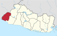 Location within El Salvador | |
| Coordinates: 13°52′01″N 89°53′31″W / 13.867°N 89.892°WCoordinates: 13°52′01″N 89°53′31″W / 13.867°N 89.892°W | |
| Country | |
| Created | 1869 |
| Seat | Ahuachapán |
| Area | |
| • Total | 1,239.6 km2 (478.6 sq mi) |
| Area rank | Ranked 8th |
| Population | |
| • Total | 333,406 |
| • Rank | Ranked 7th |
| • Density | 270/km2 (700/sq mi) |
| Time zone | UTC−6 (CST) |
| ISO 3166 code | SV-AH |

Ahuachapán is a department of El Salvador in the west of the country. The capital is Ahuachapán. In the South it has the Apenca-Ilamatepec Range and the Cerro Grande de Apaneca (Apaneca Grand Hill). Its extension is 1,240 km2 (480 sq mi) and has more than 333,000 people living in the department.
Municipalities[]
- Ahuachapán
- Apaneca
- Atiquizaya
- Concepción de Ataco
- El Refugio
- Guaymango
- Jujutla
- San Francisco Menéndez
- San Lorenzo
- San Pedro Puxtla
- Tacuba
- Turín
| Authority control |
|
|---|
Categories:
- Ahuachapán Department
- Departments of El Salvador
- States and territories established in 1869
- 1869 establishments in El Salvador