Aidlingen
Aidlingen | |
|---|---|
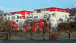
 The Aidterrassen | |
 Coat of arms | |
show Location of Aidlingen within Böblingen district | |
 Aidlingen | |
| Coordinates: 48°40′45″N 8°53′49″E / 48.67917°N 8.89694°ECoordinates: 48°40′45″N 8°53′49″E / 48.67917°N 8.89694°E | |
| Country | Germany |
| State | Baden-Württemberg |
| Admin. region | Stuttgart |
| District | Böblingen |
| Area | |
| • Total | 26.56 km2 (10.25 sq mi) |
| Elevation | 427 m (1,401 ft) |
| Population (2020-12-31)[1] | |
| • Total | 9,233 |
| • Density | 350/km2 (900/sq mi) |
| Time zone | UTC+01:00 (CET) |
| • Summer (DST) | UTC+02:00 (CEST) |
| Postal codes | 71134 |
| Dialling codes | 07034 07056 |
| Vehicle registration | BB |
| Website | www |
Aidlingen is a municipality in the district of Böblingen in Baden-Württemberg in Germany.
History[]
The County of Württemberg came into possession of Aidlingen when it was sold to Württemberg by the Lords of Bondorf in 1365. Aidlingen was ruled from the city of Böblingen while nearby Dachtal was given to the jurisdiction of Calw. Aidlingen expanded substantially and industrialized after World War II, particularly in the 1960s and 1970s. Dachtal was incorporated into Aidlingen in 1971 and nearly doubled in size through the 1980s.[2]
Geography[]
The municipality (Gemeinde) of Aidlingen is found in the district of Böblingen, in the German state of Baden-Württemberg. Aidlingen lies on the western edge of Böblingen district, along its border with Calw's district, and physically in the Heckengäu and the regions. The main watercourse in the municipal area is the Würm, which flows north-to-west through the eastern portion of the municipality. The lowest elevation above sea level in the municipal area, 403 meters (1,322 ft) Normalnull (NN), is found along the Würm. The highest, 576 meters (1,890 ft) NN, is near Dachtal.[2]
Besides Aidlingen itself, the municipality contains Ortsteile (districts) Deufringen, Dachtel, and Lehenweiler.[3]
Politics[]
Aidlingen has three boroughs (Ortsteile): Aidlingen, Dachtal, and Deufringen.[2]
Ekkehard Fauth has been the mayor of Aidlingen since 2000.[4]
Coat of arms[]
Aidlingen's coat of arms displays a blue and yellow globus cruciger upon a field of white. The globus cruciger has been a motif associated with Aidlingen since 1609 and it was used in the seal of the local Schultheiß from the 19th century to 1923. On 20 December 1929, at the insistence of the Böblingen district office, Aidlingen's municipal council adopted a coat of arms that pictured a globus cruciger in a white above one of blue with a rake and scythe, crossed and in white. These agricultural implements were removed from the coat of arms in 1971. The revised pattern was approved by the Federal Ministry of the Interior on 12 January 1973 and municipal flag was issued by the same body to accompany the new coat of arms.[2]
Transportation[]
Aidlingen is connected to Germany's network of roadways by Bundesautobahn 81. Local public transportation is provided by the Verkehrs- und Tarifverbund Stuttgart.[2]
References[]
- ^ "Bevölkerung nach Nationalität und Geschlecht am 31. Dezember 2020". Statistisches Landesamt Baden-Württemberg (in German). June 2021.
- ^ Jump up to: a b c d e "Aidlingen". LEO-BW (in German). Baden-Württemberg. Retrieved 23 July 2020.
- ^ "Zahlen & Daten". Gemeinde Aidlingen.
- ^ Schieferecke, Marc (9 October 2016). "Der neue Rathauschef ist der alte". Stuttgarter Zeitung (in German). Retrieved 15 October 2016.
External links[]
| Wikimedia Commons has media related to Aidlingen. |
- Official website
 (in German)
- Municipalities in Baden-Württemberg
- Böblingen (district)
- Württemberg


