Albbruck
Albbruck | |
|---|---|
 Church of Saint Joseph | |
 Coat of arms | |
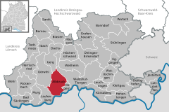
show Location of Albbruck within Waldshut district | |
 Albbruck | |
| Coordinates: 47°35′21″N 08°07′45″E / 47.58917°N 8.12917°ECoordinates: 47°35′21″N 08°07′45″E / 47.58917°N 8.12917°E | |
| Country | Germany |
| State | Baden-Württemberg |
| Admin. region | Freiburg |
| District | Waldshut |
| Area | |
| • Total | 39.69 km2 (15.32 sq mi) |
| Elevation | 324 m (1,063 ft) |
| Population (2020-12-31)[1] | |
| • Total | 7,401 |
| • Density | 190/km2 (480/sq mi) |
| Time zone | UTC+01:00 (CET) |
| • Summer (DST) | UTC+02:00 (CEST) |
| Postal codes | 79774 |
| Dialling codes | 07753 |
| Vehicle registration | WT |
| Website | www |


Albbruck is a municipality of the district of Waldshut in Baden-Württemberg, Germany.
History[]
Albbruck became, in 1805 and during the process of German mediatization, a possession of the Grand Duchy of Baden. In 1939, the town was assigned to the district of Waldshut. Albbruck experienced a period of growth beginning in the 1970s, with residential areas being added to the west side of the town and commercial space to its north. A new town hall was constructed in 1973. The municipality also grew in that period, with , Buch, and Unteralpfen being merged into Albbruck on 1 January 1975. A new town center was completed in 2000.[2]
Geography[]
The municipality (Gemeinde) of Albbruck lies at the southern edge of the district of Waldshut in Baden-Württemberg, a state of the Federal Republic of Germany. It lies along the High Rhine and the national border with Switzerland, and extends from there north into the Hotzenwald. The municipality is crossed by the chine valleys of the Mühlbach and Alb rivers. of the former is a Federally-protected nature reserve and the latter forms part of the municipality's northwest border. Elevation above sea level in the municipal area ranges from a high of 729 meters (2,392 ft) Normalnull (NN) in the Hotzenwald to a low of about 300 meters (980 ft) on the Rhine.[2]
Coat of arms[]
Albbruck's coat of arms depicts a blue river crossed by a bridge of red masonry, from which two fir trees grow, over a field of white. This pattern was first used in seals from the late 19th century, but was approved for official use by the Federal Ministry of the Interior on 2 November 1956. The pattern was again approved, this time by the, Waldshut district office, on 13 May 1977, following the absorption of Birkingen, Buch, and Unteralpfen into Albbruck. The river on the shield is the Alb, a tributary of the High Rhine whose mouth is located in the town itself. The two trees are from the arms of the .[2]
Twin towns[]
Albbruck has been twinned with Carmignano di Brenta, Italy, since 1959.[3]
Transportation[]
Albbruck is connected to Germany's network of Federal highways by . The High Rhine Railway also passes through the municipality. Traffic into Switzerland from Albbruck is made possible by the , in operation since 1933.[2]
References[]
- ^ "Bevölkerung nach Nationalität und Geschlecht am 31. Dezember 2020". Statistisches Landesamt Baden-Württemberg (in German). June 2021.
- ^ Jump up to: a b c d "Albbruck". LEO-BW (in German). Baden-Württemberg. Retrieved 15 July 2020.
- ^ Dehmel, Doris (7 February 2020). "Seit 60 Jahren Freunde: Albbruck und Carmignano di Brenta feiern Jumelage". Südkurier (in German). Retrieved 15 July 2020.
External links[]
- Official website
 (in German)
| show Towns and municipalities in Waldshut (district) |
|---|
| Authority control |
|---|
- Municipalities in Baden-Württemberg
- Waldshut (district)
- Baden
- Germany–Switzerland border crossings
- Hotzenwald