Alexanderplatz
Coordinates: 52°31′18″N 13°24′48″E / 52.52167°N 13.41333°E

This article may be expanded with text translated from the corresponding article in French. (April 2015) Click [show] for important translation instructions.
|
This article may be expanded with text translated from the corresponding article in German. (April 2015) Click [show] for important translation instructions.
|
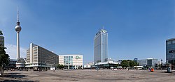


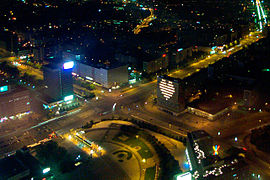
Alexanderplatz (German: [alɛkˈsandɐˌplats] (![]() listen)) is a large public square and transport hub in the central Mitte district of Berlin. The square is named after the Russian Tsar Alexander I and is often referred to simply as Alex, which also denotes the larger neighbourhood stretching from Mollstraße in the north-east to Spandauer Straße and the Rotes Rathaus in the south-west.
listen)) is a large public square and transport hub in the central Mitte district of Berlin. The square is named after the Russian Tsar Alexander I and is often referred to simply as Alex, which also denotes the larger neighbourhood stretching from Mollstraße in the north-east to Spandauer Straße and the Rotes Rathaus in the south-west.
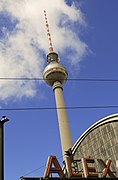
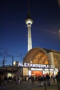
With more than 360,000 visitors daily,[1] Alexanderplatz is, according to one study, the most visited area of Berlin, beating Friedrichstrasse and City West.[2] It is a popular starting point for tourists, with many attractions including the Fernsehturm (TV tower), the Nikolai Quarter and the Rotes Rathaus (Red city hall) situated nearby. Alexanderplatz is still one of Berlin's major commercial areas, housing various shopping malls, department stores and other large retail locations.
Roads and public transport[]


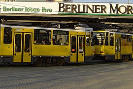
During the post-war reconstruction of the 1960s, Alexanderplatz was completely pedestrianized. Since then, trams were reintroduced to the area in 1998.
Alexanderplatz station provides S-Bahn connections, access to the U2, U5 and U8 subway lines, regional train lines for DB Regio and ODEG services and, on weekends, the Harz-Berlin-Express (HBX). Several tram and bus lines also service the area.
The following main roads connect to Alexanderplatz:
- Northwest: Karl-Liebknecht-Straße (federal highways B 2 and B 5)
- Northeast: Alexanderstraße (B 2 and B 5)
- Southeast: Grunerstraße / Alexanderstraße (B 1)
- Southwest (in front of the S-Bahn station, in the pedestrian zone): Dircksenstraße
Several arterial roads lead radially from Alexanderplatz to the outskirts of Berlin. These include (clockwise from north to south-east):
- Memhardstraße / Rosa-Luxemburg-Straße – Rosa-Luxemburg-Platz – Schönhauser Allee (to Bundesstraße 96a)
- Karl-Liebknecht-Straße – intersection Mollstraße/Prenzlauer Tor – Prenzlauer Allee (main road 109 to the Pankow triangle at the Berliner Ring)
- Grunerstraße / Alexanderstraße – Otto-Braun-Straße (B 2) – (intersection Mollstraße) – Greifswalder Straße (B 2 via Berliner Allee to the Barnim junction at Berliner Ring)
Karl-Marx-Allee (B 1 and B 5) – Strausberger Platz – Karl-Marx-Allee / Frankfurter Tor – Frankfurter Allee (B 1 and B 5 to Berlin-Hellersdorf junction at Berliner Ring)
History[]


Early history to the 18th century[]
A hospital stood at the location of present-day Alexanderplatz since the 13th century. Named Heiliger Georg (St. George), the hospital gave its name to the nearby Georgentor (George Gate) of the Berlin city wall. Outside the city walls, this area was largely undeveloped until around 1400, when the first settlers began building thatched cottages. As a gallows was located close by, the area earned the nickname the "Teufels Lustgarten" (the Devil's Pleasure Garden).[3]

The George Gate became the most important of Berlin's city gates during the 16th century, being the main entry point for goods arriving along the roads to the north and north-east of the city, for example from Oderberg, Prenzlau and Bernau, and the big Hanseatic cities on the Baltic Sea.
After the Thirty Years' War, the city wall was strengthened. From 1658 to 1683, a citywide fortress was constructed to plans by the Linz master builder, Johann Gregor Memhardt. The new fortress contained 13 bastions connected by ramparts and was preceded by a moat measuring up to 50 meters wide. Within the new fortress, many of the historic city wall gates were closed. For example, the southeastern Stralauer Gate was closed but the Georgian Gate remained open, making the Georgian Gate an even more important entrance to the city.
In 1681, the trade of cattle and pig fattening was banned within the city. Frederick William, the Great Elector, granted cheaper plots of land, waiving the basic interest rate, in the area in front of the Georgian Gate. Settlements grew rapidly and a weekly cattle market was established on the square in front of the Gate.
The area developed into a suburb – the Georgenvorstadt – which continued to flourish into the late 17th century. Unlike the southwestern suburbs (Friedrichstadt, Dorotheenstadt) which were strictly and geometrically planned, the suburbs in the northeast (Georgenvorstadt, Spandauervorstadt and the Stralauer Vorstadt) proliferated without plan. Despite a building ban imposed in 1691, more than 600 houses existed in the area by 1700.
At that time, the George Gate was a rectangular gatehouse with a tower. Next to the tower stood a remaining tower from the original medieval city walls. The upper floors of the gatehouse served as the city jail.[4] A drawbridge spanned the moat and the gate was locked at nightfall by the garrison using heavy oak planks.
A highway ran through the cattle market to the northeast towards Bernau. To the right stood the George chapel, an orphanage and a hospital that was donated by the Elector Sophie Dorothea in 1672. Next to the chapel stood a dilapidated medieval plague house which was demolished in 1716. Behind it was a rifleman's field and an inn, later named the Stelzenkrug.
By the end of the 17th century, 600 to 700 families lived in this area. They included butchers, cattle herders, shepherds and dairy farmers. The George chapel was upgraded to the George church and received its own preacher.
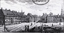
Königs Thor Platz (1701–1805)[]

After his coronation in Königsberg on 6 May 1701 the Prussian King Frederick I entered Berlin through the George Gate. This led to the gate being renamed the , and the surrounding area became known in official documents as Königs Thor Platz (King's Gate Square). The Georgenvorstadt suburb was renamed Königsvorstadt (or royal city for short).
In 1734, the Berlin Customs Wall, which initially consisted of a ring of palisade fences, was reinforced and grew to encompass the old city and its suburbs, including Königsvorstadt. This resulted in the King's Gate losing importance as an entry point for goods into the city. The gate was finally demolished in 1746.
By the end of the 18th century, the basic structure of the royal suburbs of the Königsvorstadt had been developed. It consisted of irregular-shaped blocks of buildings running along the historic highways which once carried goods in various directions out of the gate. At this time, the area contained large factories (silk and wool), such as the Kurprinz (one of Berlin's first cloth factories, located in a former barn) and a workhouse established in 1758 for beggars and homeless people, where the inmates worked a man-powered treadmill to turn a mill.[5]
Soon, military facilities came to dominate the area, such as the 1799–1800 military parade grounds designed by David Gilly. At this time, the residents of the platz were mostly craftsmen, petty-bourgeois, retired soldiers and manufacturing workers.[5] The southern part of the later Alexanderplatz was separated from traffic by trees and served as a parade ground, whereas the northern half remained a market. Beginning in the mid-18th century, the most important wool market in Germany was held in Alexanderplatz.
Between 1752 and 1755, the writer Gotthold Ephraim Lessing lived in a house on Alexanderplatz. In 1771, a new stone bridge (the Königsbrücke) was built over the moat and in 1777 a colonnade-lined row of shops (Königskolonnaden) was constructed by architect Carl von Gontard. Between 1783 and 1784, seven three-storey buildings were erected around the square by Georg Christian Unger, including the famous Gasthof zum Hirschen, where Karl Friedrich Schinkel lived as a permanent tenant and Heinrich von Kleist stayed in the days before his suicide.
Alexanderplatz (1805–1900)[]
On 25 October 1805 the Russian Tsar Alexander I was welcomed to the city on the parade grounds in front of the old King's Gate. To mark this occasion, on 2 November, King Frederick William III ordered the square to be renamed Alexanderplatz:[6]
"His Royal Majesty, by means of the supreme Cabinet, orders on the 2nd of this month, those in the Königs-Vorstadt Sandgasse to take the name Kaiserstrasse, and the square in front of the workhouse in the newly-conceived suburb settles with the name of Alexander-Platz, this is hereby made known to the public for news and attention."
— Royal Preuss. Police Directorate
In the southeast of the square, the cloth factory buildings were converted into the Königstädter Theater by Carl Theodor Ottmer at a cost of 120,000 Taler. The foundation stone was laid on 31 August 1823 and the opening ceremony occurred on 4 August 1824. Sales were poor, forcing the theatre to close on 3 June 1851. Thereafter, the building was used for wool storage, then as a tenement building, and finally as an inn called Aschinger until the building's demolition in 1932.
During these years, Alexanderplatz was populated by fish wives, water carriers, sand sellers, rag-and-bone men, knife sharpeners and day laborers.[6]
Because of its importance as a transport hub, horse-drawn buses ran every 15 minutes between Alexanderplatz and Potsdamer Platz in 1847.[7]
During the March Revolution of 1848, large-scale street fighting occurred on the streets of Alexanderplatz, where revolutionaries used barricades to block the route from Alexanderplatz to the city. Novelist and poet Theodor Fontane, who worked in the vicinity in a nearby pharmacy, participated in the construction of barricades and later described how he used materials from the Königstädter Theater to barricade Neue Königstraße.[8]
The Königsstadt continued to grow throughout the 19th century, with three-storey developments already existing at the beginning of the century and fourth storeys being constructed from the middle of the century. By the end of the century, most of the buildings were already five storeys high. The large factories and military facilities gave way to housing developments (mainly rental housing for the factory workers who had just moved into the city) and trading houses.
At the beginning of the 1870s, the Berlin administration had the former moat filled to build the Berlin city railway, which was opened in 1882 along with Bahnhof Alexanderplatz (Alexanderplatz Railway Station).
In 1883–1884, the Grand Hotel, a neo-Renaissance building with 185 rooms and shops beneath was constructed. From 1886 to 1890, Hermann Blankenstein built the Police headquarters, a huge brick building whose tower on the northern corner dominated the building. In 1890, a district court at Alexanderplatz was also established.
In 1886, the local authorities built a central market hall west of the rail tracks, which replaced the weekly market on the Alexanderplatz in 1896. During the end of the 19th century, the emerging private traffic and the first horse bus lines dominated the northern part of the square, the southern part (the former parade ground) remained quiet, having green space elements added by garden director Hermann Mächtig in 1889. The northwest of the square contained a second, smaller green space where, in 1895, the 7.5-meter copper Berolina statue by sculptor Emil Hundrieser was erected.
Highpoint between the Empire and the Nazi era (1900–1940)[]
At the beginning of the 20th century, Alexanderplatz experienced its heyday. In 1901, Ernst von Wolzogen founded the first German cabaret, the Überbrettl, in the former Sezessionsbühne (Secession stage) at Alexanderstraße 40, initially under the name Bunte Brettl. It was announced as "Kabarett as upscale entertainment with artistic ambitions. Emperor-loyal and market-oriented stands the uncritical amusement in the foreground."
The merchants Hermann Tietz, Georg Wertheim and Hahn opened large department stores on Alexanderplatz: Tietz (1904–1911), Wertheim (1910–1911) and Hahn (1911). Tietz marketed itself as a department store for the Berlin people, whereas Wertheim modelled itself as a department store for the world.
In October 1905, the first section of the Tietz department store opened to the public. It was designed by architects Wilhelm Albert Cremer and Richard Wolffenstein, who had already won second prize in the competition for the construction of the Reichstag building. The Tietz department store underwent further construction phases and, in 1911, had a commercial space of 7,300 square meters and the longest department store facade in the world at 250 meters in length.[9]
For the construction of the Wertheim department store, by architects and Karl von Großheim, the Königskolonnaden were removed in 1910 and now stand in the Heinrich von Kleist Park in Schöneberg.
In October 1908, the Haus des Lehrers (house of teachers) was opened next to the Bunte Brettl at Alexanderstraße 41. It was designed by Hans Toebelmann and Henry Gross. The building belonged to the Berliner Lehrererverein (teachers’ association), who rented space on the ground floor of the building out to a pastry shop and restaurant to raise funds for the association. The building housed the teachers' library which survived two world wars, and today is integrated into the library for educational historical research.[9] The rear of the property contained the association's administrative building, a hotel for members and an exhibition hall. Notable events that took place in the hall include the funeral services for Karl Liebknecht and Rosa Luxemburg on 2 February 1919 and, on 4 December 1920, the Vereinigungsparteitag (Unification Party Congress) of the Communist Party and the USPD.
The First Ordinary Congress of the Communist Workers Party of Germany was held in the nearby Zum Prälaten restaurant, 1–4 August 1920.
Alexanderplatz's position as a main transport and traffic hub continued to fuel its development. In addition to the three U-Bahn underground lines, long-distance trains and S-Bahn trains ran along the Platz's viaduct arches. Omnibuses, horse-drawn from 1877 and, after 1898, also electric-powered trams,[10] ran out of Alexanderplatz in all directions in a star shape. The subway station was designed by Alfred Grenander and followed the colour-coded order of subway stations, which began with green at Leipziger Platz and ran through to dark red.
In the Golden Twenties, Alexanderplatz was the epitome of the lively, pulsating cosmopolitan city of Berlin, rivalled in the city only by Potsdamer Platz. Many of the buildings and rail bridges surrounding the platz bore large billboards that illuminated the night. The Berlin cigarette company Manoli had a famous billboard at the time which contained a ring of neon tubes that constantly circled a black ball. The proverbial "Berliner Tempo" of those years was characterized as "total manoli". Writer Kurt Tucholsky wrote a poem referencing the advert, and the composer Rudolf Nelson made the legendary Revue Total manoli with the dancer . The writer Alfred Döblin named his novel, Berlin Alexanderplatz, after the square and Walter Ruttmann filmed his 1927 film Berlin: Die Sinfonie der Großstadt (Berlin: The symphony of the big city) at Alexanderplatz.
Destruction of Alexanderplatz (1940–1945)[]

One of Berlin's largest air-raid shelters during the Second World War was situated under Alexanderplatz. It was built between 1941 and 1943 for the Deutsche Reichsbahn by Philipp Holzmann.[11]
The war reached Alexanderplatz in early April 1945. The Berolina statue had already been removed in 1944 and probably melted down for use in arms production. During the Battle of Berlin, Red Army artillery bombarded the area around Alexanderplatz. The battles of the last days of the war destroyed considerable parts of the historic Königsstadt, as well as many of the buildings around Alexanderplatz.
The Wehrmacht had entrenched itself within the tunnels of the underground system. Hours before fighting ended in Berlin on 2 May 1945, troops of the SS detonated explosives inside the north-south S-Bahn tunnel under the Landwehr Canal to slow the advance of the Red Army towards Berlin's city centre. The entire tunnel flooded, as well as large sections of the U-Bahn network via connecting passages at the Friedrichstraße underground station. Many of those seeking shelter in the tunnels were killed.[11] Of the then 63.3 kilometres of subway tunnel, around 19.8 kilometres were flooded with more than one million cubic meters of water.
Demolition and reconstruction (1945–1964)[]
Before a planned reconstruction of the entire Alexanderplatz could take place, all the war ruins needed to be demolished and cleared away. A popular black market emerged within the ruined area, which the police raided several times a day.
Reconstruction planning for post-war Berlin gave priority to the dedicated space to accommodate the rapidly growing motor traffic in inner-city thoroughfares. This idea of a traffic-orientated city was already based on considerations and plans by Hilbersheimer and Le Corbusier from the 1930s.[11]
East Germany[]
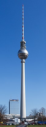
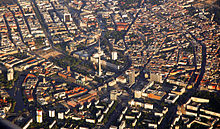
Alexanderplatz has been subject to redevelopment several times in its history, most recently during the 1960s, when it was turned into a pedestrian zone and enlarged as part of the German Democratic Republic's redevelopment of the city centre. It is surrounded by several notable structures including the Fernsehturm (TV Tower).
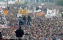
During the Peaceful Revolution of 1989, the Alexanderplatz demonstration on 4 November 1989 was the largest demonstration in the history of the German Democratic Republic. Protests starting 15 October and peaked on 4 November with an estimated 200,000 participants who called on the government of the ruling Socialist Unity Party of Germany to step down and demanded a free press, the opening of the borders and their right to travel. Speakers were Christa Wolf, Stefan Heym, Friedrich Schorlemmer, Heiner Müller, Lothar Bisky, Christoph Hein and Steffie Spira. The protests continued and culminated in the unexpected Fall of the Berlin Wall on 9 November 1989.[12]
After German reunification[]
This section needs to be updated. (December 2017) |
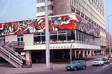
Ever since German reunification, Alexanderplatz has undergone a gradual process of change with many of the surrounding buildings being renovated. Despite the reconstruction of the tram line crossing, it has retained its socialist character, including the much-graffitied "Fountain of Friendship between Peoples" (Brunnen der Völkerfreundschaft), a popular venue.
In 1993, architect Hans Kollhoff's master plan for a major redevelopment including the construction of several skyscrapers was published.[13] Due to a lack of demand it is unlikely these will be constructed. However, beginning with the reconstruction of the Kaufhof department store in 2004, and the biggest underground railway station of Berlin, some buildings were redesigned and new structures built on the square's south-eastern side. Sidewalks were expanded to shrink one of the avenues, a new underground garage was built, and commuter tunnels meant to keep pedestrians off the streets were removed.[13] The surrounding buildings now house chain stores, fast-food restaurants, and fashion discounters.[13] The Alexa shopping mall, with approximately 180 stores opened nearby in 2007, and a large Saturn electronic store was built and opened in 2008. The CUBIX multiplex cinema, which opened in November 2000, joined the team of Berlin International Film Festival cinemas in 2007, and the festival shows films on three of its screens.[14] In January 2014, a 39-story residential tower designed by Frank Gehry was announced, but this project was put on hold in 2018.[15]
Many historic buildings are located in the vicinity of Alexanderplatz. The traditional seat of city government, the Rotes Rathaus, or Red City Hall, is located nearby, as was the former East German parliament building, the Palast der Republik. The Palast was demolished from 2006–2008 to make room for a full reconstruction of the Baroque Berlin Palace, or Stadtschloss, which is set to open in 2019.[16][17]
Alexanderplatz is also the name of the S-Bahn and U-Bahn stations there. It is one of Berlin's largest and most important transportation hubs, being a meeting place of three subway (U-Bahn) lines, three S-Bahn lines, and many tram and bus lines, as well as regional trains.
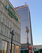
It also accommodates the Park Inn Berlin and the World Time Clock, a continually rotating installation that shows the time throughout the globe, the House of Travel, and Hermann Henselmann's House of Teachers.
Planning, renovation and reorganization after reunification (1990–2004)[]
After the political turnaround in the wake of the fall of the Berlin wall, socialist urban planning and architecture of the 1970s no longer corresponded to the current ideas of an inner-city square. Investors demanded planning security for their construction projects. After initial discussions with the public, the goal quickly arose to reinstate Alexanderplatz's tram network for better connections to surrounding city quarters. In 1993, an urban planning ideas competition for architects took place to redesign the square and its surrounding area.
In the first phase, there were 16 submissions, five of which were selected for the second phase of the competition. These five architects had to adapt their plans to detailed requirements. For example, the return of the Alex's trams was planned, with the implementation to be made in several stages.
The winner, who was determined on 17 September 1993, was the Berlin architect Hans Kollhoff. Kollhoff's plan was based on Behrens’ design, provided a horseshoe-shaped area of seven- to eight-storey buildings and 150-meter-high towers with 42 floors. The Alexanderhaus and the Berolinahaus – both listed buildings – would form the southwestern boundary. Second place went to the design by Daniel Libeskind and Bernd Faskel. The proposal of the architecture firm Kny & Weber, which was strongly based on the horseshoe shape of Wagner, finally won the third place. The design by Kollhoff was chosen on 7 June 1994 by the Berlin Senate as a basis for the further transformation of Alexanderplatz.
In 1995, Landesbank Berlin completed the renovation of the Alexanderhaus. In 1998, the first tram returned to Alexanderplatz, and in 1999, the town planning contracts for the implementation of Kollhoff and Timmermann's plans were signed by the landowners and the investors. On 2 April 2000, the Senate finally fixed the development plan for Alexanderplatz. The purchase contracts between investors and the Senate Department for Urban Development were signed on 23 May 2002, thus laying the foundations for the development.
Construction boom and redesign (since 2004)[]
Renovation of the Centrum department store began in 2004, led by Berlin professor of architecture, Josef Paul Kleihues and his son Jan Kleihues. The building was enlarged by about 25 meters and has since operated under the name Galeria Kaufhof. Between 2005 and 2006, Berolinahaus was renovated and since became a branch of the clothing chain, C&A.
In 2005, the BVG began work to extend the tram line from Prenzlauer Allee to Alexanderplatz (Alex II). This route was originally to be opened in 2000 but was postponed several times. After further delays caused by the 2006 Football World Cup, the route opened on 30 May 2007.
The renovation of Alexanderplatz U-Bahnhof, the largest Berlin underground station, had been ongoing since the mid-1990s and was finally completed in October 2008.[18]
In February 2006, the redesign of the walk-in plaza began. The redevelopment plans were provided by the architecture firm Gerkan, Marg und Partner and the Hamburg-based company WES-Landschaftsarchitekten. The final plans emerged from a design competition launched by the state of Berlin in 2004. However, the paving work was temporarily interrupted a few months after the start of construction by the 2006 Football World Cup and all excavation pits had to be provisionally asphalted over. The construction work could only be completed at the end of 2007.
The Platz was given a pavement of yellow granite, bordered by grey mosaic paving around the buildings. Wall AG modernized the 1920s-era underground toilets at a cost of 750,000 euros. The total redesign cost amounted to around 8.7 million euros.
On 12 September 2007 the shopping centre Alexa opened. It is located in the immediate vicinity of the Platz, on the site of the old Berlin police headquarters. With a 56,200 m2 sales area, it is one of the largest shopping centres in Berlin.
In May 2007, the Texas property development company Hines began building a six-story commercial building named "die mitte". The building was built on a plot of 3900 m2, which, according to the Kollhoff plans, closes the square to the east and thus reduces the area of the Platz. The building was opened on 25 March 2009.
At the beginning of 2007, the construction company Wöhr + Bauer created an underground garage with three levels below the Alexanderstraße, located between the hotel tower and the Elektroindustrie building, which cost 25 million euros to build and provides space for around 700 cars.[19] The opening took place on 26 November 2010.[20] At the same time, the Senate narrowed Alexanderstraße from almost 100 meters wide to 58 meters wide, thus reducing it to three lanes in each direction. The cost of this amounted to 9.7 million euros.
Behind the Alexanderplatz station, next to the Cubix cinema in the immediate vicinity of the TV tower, the 30-meter high residential and commercial building, Alea 101, was built between 2012 and 2014.
The Alexanderplatz area is the largest area for crime in Berlin. As of October 2017, Alexanderplatz was classified a kriminalitätsbelasteter Ort (crime-contaminated location) by the Berlin Allgemeinen Sicherheits- und Ordnungsgesetz (General Safety and Planning Laws).[21]
The future of the Platz[]

Long-term plans exist for the demolition of the 125-meter high former Interhotel Stadt Berlin (now the Hotel Park-Inn), with the site to be replaced by three skyscrapers. If and when this plan will be implemented is unclear, especially since the hotel tower received a new façade as recently as in 2005, and the occupancy rates of the hotel are very good. However, the plans could give way in the next few years to a suggested 35-meter-high new block conversion. The previous main tenant of the development, Saturn, moved into the die mitte building in March 2009. In 2014, Primark opened a branch inside the hotel building.
The majority of the planned 150-meter-high skyscrapers will probably never be built. The state of Berlin has announced that it will not enforce the corresponding urban development contracts against the market. Of the 13 planned skyscrapers, 10 remain after modifications to the plans – eight of which have construction rights.[22] Investors in the shopping centre Alexa have announced several times since 2007 that they would sell their respective shares in the plot to an investor interested in building a high-rise. Since 2010, there have been no indications of possible investors.[23]
The first concrete plans for the construction of a high-rise were made by Hines, the investor behind die mitte. In 2009, the construction of a 150-meter-high tower to be built behind die mitte was announced. On 12 September 2011, a slightly modified development plan was presented, which provided for a residential tower housing 400 apartments. In early 2013, the development plan was opened to the public.[24]
In autumn 2015, the Berlin Senate organized two forums in which interested citizens could express their opinions on the proposed changes to the Platz. Architects, city planners and Senate officials held open discussions. On that occasion, however, it was reiterated that the plans for high-rise developments were not up for debate. According to the master plan of the architect Hans Kollhoff, up to eleven huge buildings will continue to be built, which will house a mixture of shops and apartments.[25]
At the beginning of March 2018, it was announced that the Mitte district office had granted planning permission for the first residential high-rise in Alexanderplatz, the 150-metre high Alexander Tower. On 29 of the 35 floors, 377 apartments are to be built. It would be located next to the Alexa shopping centre, with a planned completion date of 2021.
Structures[]
See also : List of cultural monuments in Berlin-Mitte / Alexanderplatz
World Clock[]
→ main article: World Clock
Berolina[]
→ main article: Berolina

Fountain of Friendship[]
The Fountain of Friendship (Brunnen der Völkerfreundschaft) was erected in 1970 during the redesign of Alexanderplatz and inaugurated on October 7. It was created by Walter Womacka and his group of artists. Its water basin has a diameter of 23 meters, it is 6.20 meters high and is built from embossed copper, glass, ceramics and enamel. The water spurts from the highest point and then flows down in spirals over 17 shells, which each have a diameter between one and four meters. After Die Wende, it was completely renovated in a metal art workshop during the reconstruction of the Galeria Kaufhof.
Other[]
Apart from Hackescher Markt, Alexanderplatz is the only existing square in front of one of the medieval gates of Berlin's city wall.
Image gallery[]
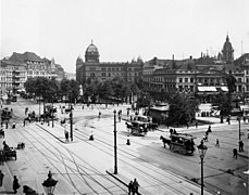
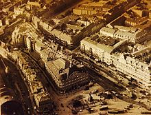
Alexanderplatz, 1908 (l-r :Lehrervereinshaus, Polizeipräsidium, Aschinger)

The World Clock with the Fernsehturm in the background

Alexanderhaus
Project Blinkenlights

Die Mitte shopping mall
Tram at Alexanderplatz
Fernsehturm on "Alex"

The World Clock and Park Inn hotel in the background

Night view of the World Clock
Bahnhof Alexanderplatz and the Fernsehturm
Park Inn with a reflection from the Fernsehturm.


Further reading[]
- Weszkalnys, Gisa (2010). Berlin, Alexanderplatz: Transforming Place in a Unified Germany. Berghahn Books.
External links[]
| Wikimedia Commons has media related to Alexanderplatz (Berlin-Mitte). |
References[]
- ^ "Investor plant höchstes Haus Berlins". www.tagesspiegel.de (in German). Retrieved 2019-01-24.
- ^ "Hines – Berlin Alexanderplatz – Berlins meistbesuchte Destination". www.alexanderplatz.de. Retrieved 2019-01-24.
- ^ Aus der Geschichte des Alexanderplatzes, BZA, Teil 1: Foltergebühr: 10 Schillinge.
- ^ Serie Aus der Geschichte des Alexanderplatzes, T. 2: Rüger auf der Lauer.
- ^ a b Serie Aus der Geschichte des Alexanderplatzes, T. 3: Tretmühle im Arbeitshaus.
- ^ a b Aus der Geschichte des Alexanderplatzes, T. 4: Taufe
- ^ Behrens, Peter (1993). Peter Behrens, Berlin Alexanderplatz: Pläne, Zeichnungen und Photographien zum Wettewerb und der Bebauung, 1929–1932. Fiedler-Bender, Gisela; Höfchen, Heinz; Pfalzgalerie Kaiserslautern. [Kaiserslautern]: [Die Pfalzgalerie]. ISBN 389422066X. OCLC 28807743.
- ^ Theodor Fontane: Von Zwanzig bis Dreißig. Abschnitt Der achtzehnte März. Erstes Kapitel.
- ^ a b Jochheim, Gernot (2006). Der Berliner Alexanderplatz. CH. Links Verlag (Sachbuch). ISBN 9783861533917. OCLC 984942416.
- ^ Hans-Joachim Pohl: Chronik des Straßenbahnverkehrs auf dem Alexanderplatz. In: Verkehrsgeschichtliche Blätter. Heft 1, 1999, S. 17–18
- ^ a b c "Berliner Unterwelten e.V. | TIEFBUNKER UNTER DEM ALEXANDERPLATZ". 2015-04-18. Archived from the original on 2015-04-18. Retrieved 2019-01-30.
- ^ Kowalczuk, Ilko-Sascha (2009). Endspiel, die Revolution von 1989 in der DDR [Endgame, the 1989 Revolution in the GDR] (in German). Munich: C.H. Beck Verlag. ISBN 9783406583575.
- ^ a b c Dalia Fahmy (27 May 2014), "25 Years After Communism, Eyesores Spur Landmark Debate" The Wall Street Journal.
- ^ "Berlinale venues". berlinale.de. Archived from the original on 2 February 2017. Retrieved 17 August 2018.
- ^ "Frank Gehry's plans for Berlin's tallest skyscraper put on hold". 2018-05-03.
- ^ "The New Palace: Neo-Baroque in Berlin". Spiegel Online. 4 December 2008. Retrieved 17 August 2018.
- ^ "Finally – Berlin has its palace again! | DW | 23.08.2018".
- ^ Berlin, Berliner Morgenpost- (2008-10-18). "U-Bahnhof Alexanderplatz ist endlich fertig". www.morgenpost.de (in German). Retrieved 2020-09-03.
- ^ Flatau, Sabine (2009-08-14). "Ein See in der Baustelle am Alexanderplatz". www.morgenpost.de (in German). Retrieved 2020-09-03.
- ^ Zeitung, Berliner. "Am Alexanderplatz wurde drei Jahre lang ein unterirdisches Parkhaus gebaut, es eröffnet Ende November. Doch viele Straßen und Gehwege sind noch nicht fertig: Schmale Straße und tiefe Garage". Berliner Zeitung (in German). Retrieved 2020-09-03.
- ^ "Kriminalitätsbelastete Orte in Berlin". www.berlin.de (in German). 2019-03-18. Retrieved 2020-09-03.
- ^ "Die Riesen kommen kleckerweise". www.tagesspiegel.de (in German). Retrieved 2020-09-08.
- ^ Hein, Rainer L. (2008-04-17). "Riesenhochhaus: 150-Meter-Wolkenkratzer wird am Alex gebaut". DIE WELT. Retrieved 2020-09-08.
- ^ "Erster Wohnturm am Alexanderplatz in Berlin » News". 2014-02-02. Archived from the original on 2014-02-02. Retrieved 2020-09-08.
- ^ Zeitung, Berliner. "Bürgerdialog in Berlin: Zacken und Flügel am Fernsehturm". Berliner Zeitung (in German). Retrieved 2020-09-08.
 | |||
| Authority control |
|---|
- Mitte
- Squares in Berlin
- Zones of Berlin
- Cremer & Wolffenstein