Alkmonton
| Alkmonton | |
|---|---|
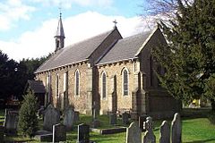
 St. John's church | |
 Alkmonton parish highlighted within Derbyshire | |
| OS grid reference | SK1838 |
| Shire county | |
| Region | |
| Country | England |
| Sovereign state | United Kingdom |
| Post town | Ashbourne |
| Postcode district | DE6 |
| Police | Derbyshire |
| Fire | Derbyshire |
| Ambulance | East Midlands |
Alkmonton is a village and civil parish in the Derbyshire Dales district of Derbyshire, England, roughly between Uttoxeter and Derby. The parish had a population of 75 at the 2001 census and it remained less than 100 in 2011. Details are included in the civil parish of Cubley, Derbyshire.
History[]
The village's name is derived from the Old English for "Ealhmund's settlement".[1] Alkmonton was mentioned in the Domesday book as belonging to Henry de Ferrers and was worth forty shillings.[2]
Wulfgeat had 1½ carucates of land to the geld. There is land for two ploughs. There are now two ploughs in Demesne; and 8 Villans and 7 Bordars having two ploughs, and 12 acres of meadow. There is woodland pasture 1 league long and a half broad. TRE[3] worth 60s now 40s. Ralph holds it.[2]
In about 1100 a hospital for female lepers was founded between Alkmonton and Hungry Bentley by Robert de Bakepuze. It went into decline but was re-founded in 1406, only to be abolished in 1547 due to the reformation. The ownership of the manor of Alkmonton passed through several families to the Evans, who in 1843 built the parish church of St John (a Grade II listed building[4]).[5][6][7]
The earthworks of the medieval village of Alkmonton are a short distance south of the present village.
See also[]
References[]
- ^ "Alkmonton". Key to English Place-names. English Place Name Society at the University of Nottingham. Retrieved 19 August 2013.
- ^ a b Domesday Book: A Complete Translation. London: Penguin. 2003. p. 746. ISBN 0-14-143994-7.
- ^ TRE means in the time of King Edward so that would have been 60s but now worth 40s.
- ^ Historic England. "Church of St John (Grade II) (1335021)". National Heritage List for England. Retrieved 31 October 2020.
- ^ Lewis, Samuel, ed. (1848). "Alfrick – Allerston". A Topographical Dictionary of England. London: S. Lewis. pp. 34–37. Retrieved 31 January 2018 – via British History Online.
- ^ Page, William, ed. (1907). "Hospitals: Alkmonton". A History of the County of Derby. Vol. 2. London: Victoria County History. pp. 80–81. Retrieved 31 January 2018 – via British History Online.
- ^ Historic England. "Medieval basement below numbers 38 and 39 (1116387)". National Heritage List for England. Retrieved 31 January 2018.
External links[]
 Media related to Alkmonton at Wikimedia Commons
- Alkmonton in the Domesday Book
Coordinates: 52°56′N 1°44′W / 52.93°N 01.73°W
- Villages in Derbyshire
- Towns and villages of the Peak District
- Civil parishes in Derbyshire
- Derbyshire Dales
- Derbyshire geography stubs
