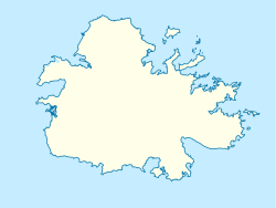
All Saints, Antigua and Barbuda
All Saints | |
|---|---|
Village | |
 All Saints | |
| Coordinates: 17°03′N 61°47′W / 17.050°N 61.783°WCoordinates: 17°03′N 61°47′W / 17.050°N 61.783°W | |
| Country | Antigua and Barbuda |
| Island | Antigua |
| Elevation | 60 m (200 ft) |
| Population (2001) | |
| • Total | 3,900 |
| Time zone | UTC-4 (AST) |
All Saints is the second largest town in Antigua and Barbuda, with a population of 3,412. It is located in the middle of Antigua, at 17°3′N 61°47′W / 17.050°N 61.783°W. Just 5 miles NW of here is the capital, St. John's. It had a population of 3,900 in 2001.
Within the vicinity of the town is Betty's Hope, the first large-scale sugarcane plantation in Antigua. Betty's Hope was built in 1674 by Sir Christopher Codrington, the namesake of Codrington, and was named for his daughter, Elizabeth Codrington. The only remaining structures are two stone sugar mills and the remains of the stillhouse, though its important role in Antigua's history has inspired its government to turn it into an open-air museum.[1]
The area around All Saints is known for its traditional pottery. Potter's Village, a nearby settlement, is named after it.
References[]
- ^ "Antigua and Barbuda / Exploring Antigua and Barbuda". Archived from the original on 2012-04-05. Retrieved 2007-10-27.
- Populated places in Antigua and Barbuda
- Antigua (island)
- Antigua and Barbuda geography stubs
