Altenkunstadt
Altenkunstadt | |
|---|---|
 Church of the Nativity of the Virgin Mary and the rectory | |
 Coat of arms | |
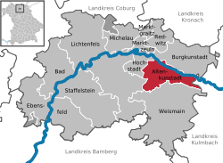
show Location of Altenkunstadt within Lichtenfels district | |
 Altenkunstadt | |
| Coordinates: 50°07′N 11°15′E / 50.117°N 11.250°ECoordinates: 50°07′N 11°15′E / 50.117°N 11.250°E | |
| Country | Germany |
| State | Bavaria |
| Admin. region | Oberfranken |
| District | Lichtenfels |
| Subdivisions | 12 Ortsteile |
| Government | |
| • Mayor (2020–26) | Robert Hümmer[1] (CSU) |
| Area | |
| • Total | 32.91 km2 (12.71 sq mi) |
| Elevation | 292 m (958 ft) |
| Population (2020-12-31)[2] | |
| • Total | 5,454 |
| • Density | 170/km2 (430/sq mi) |
| Time zone | UTC+01:00 (CET) |
| • Summer (DST) | UTC+02:00 (CEST) |
| Postal codes | 96264 |
| Dialling codes | 09572 |
| Vehicle registration | LIF/STE |
| Website | www.altenkunstadt.de |


Altenkunstadt is a municipality in the district of Lichtenfels in Bavaria, Germany. It lies on the left or south bank of the river Main across the valley from Burgkunstadt which sits on the hillside to the north.
Sons and daughters[]
- Wolfgang Mack (1808-1883), German surgeon
- Alfred Nikolaus Witt (1914-1999), orthopedist and surgeon, university professor in Berlin and Munich
- Josef Seiz (1934-2010), German table tennis player
References[]
- ^ Liste der ersten Bürgermeister/Oberbürgermeister in kreisangehörigen Gemeinden, Bayerisches Landesamt für Statistik, 15 July 2021.
- ^ "Tabellenblatt "Daten 2", Statistischer Bericht A1200C 202041 Einwohnerzahlen der Gemeinden, Kreise und Regierungsbezirke". Bayerisches Landesamt für Statistik (in German). June 2021.
| show Towns and municipalities in Lichtenfels district |
|---|
| Authority control |
|---|
This Lichtenfels district location article is a stub. You can help Wikipedia by . |
Categories:
- Municipalities in Bavaria
- Lichtenfels (district)
- Upper Franconia geography stubs