Alvier (mountain)
| Alvier | |
|---|---|
 | |
| Highest point | |
| Elevation | 2,343 m (7,687 ft) |
| Prominence | 243 m (797 ft)[1] |
| Parent peak | Gamsberg |
| Isolation | 2.59 km (1.61 mi) |
| Coordinates | 47°06′35.1″N 09°24′53.4″E / 47.109750°N 9.414833°ECoordinates: 47°06′35.1″N 09°24′53.4″E / 47.109750°N 9.414833°E |
| Geography | |
 Alvier Location in Switzerland | |
| Location | St. Gallen, Switzerland |
| Parent range | Appenzell Alps |

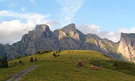
The Alvier (German pronunciation: [alˈfiːɐ̯] (![]() listen)) is a mountain in the Appenzell Alps, located halfway between Lake Walenstadt and the Rhine in the canton of St. Gallen. It is one of the main summits of the chain separating the valleys of the river Seez and the Rhine.
listen)) is a mountain in the Appenzell Alps, located halfway between Lake Walenstadt and the Rhine in the canton of St. Gallen. It is one of the main summits of the chain separating the valleys of the river Seez and the Rhine.
Although involving a long hike, the summit is easily accessible by trails from both sides.
References[]
| Authority control |
|
|---|
This Switzerland mountain, mountain range, or peak related article is a stub. You can help Wikipedia by . |
Categories:
- Mountains of the Alps
- Mountains of Switzerland
- Mountains of the canton of St. Gallen
- Appenzell Alps
- Switzerland mountain stubs