Ambrózfalva
This article may be expanded with text translated from the corresponding article in Hungarian. (December 2013) Click [show] for important translation instructions.
|
Ambrózfalva | |
|---|---|
 Coat of arms | |
| Country | |
| County | Csongrád |
| Area | |
| • Total | 11.22 km2 (4.33 sq mi) |
| Population (2013) | |
| • Total | 503 |
| • Density | 44.8/km2 (116/sq mi) |
| Time zone | UTC+1 (CET) |
| • Summer (DST) | UTC+2 (CEST) |
| Postal code | 6916 |
| Area code(s) | 62 |

Ambrózfalva is a village in Csongrád County,[1] in the Southern Great Plain region of southern Hungary.
Geography[]
It covers an area of 11.22 km2 (4 sq mi) and has a population of 503 people (2013 estimate).[2]
Population[]
| Year | 1980 | 1990 | 2001 | 2010 | 2011 | 2013 |
|---|---|---|---|---|---|---|
| Population | 581 (census)[2] | 555 (census)[2] | 525 (census)[2] | 498 (estimate)[3] | 496 (census)[2] | 503 (estimate)[2] |
Demographic[]
Ambrózfalva's population declared themselves as 86% Hungarian nationality, 13% Slovak nationality, and 1% Romanian nationality in a 2001 census.[4]
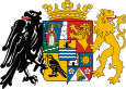
Coat of arms[]
The coat of arms of Ambrózfalva has two images: three ears of corn on the left side, and a patriarchal cross on the right. The three ears of corn act as a reference to the agricultural characteristics of the village and the area. The golden ears of corn symbolize the ancestors' settling in and also represents their success. The patriarchal cross is similar to that of the coat of arms of Slovakia and is a reminder of the Slovak origin of the population of the area. It also represents the importance of recognizing national and ethnic traditions.[5]
References[]
- ^ "Ambrózfalva City Info". CitySeek.org. Retrieved 9 December 2013.
- ^ a b c d e f "Ambrózfalva Population Table". citypopulation.de. Retrieved 9 December 2013.
- ^ "Helységnévkönyv adattár 2010". KSH (Hungarian Central Statisctical Office). 1 January 2010. Archived from the original on 7 November 2012. Retrieved 9 December 2013.
- ^ "A 2001-es népszámlálás nemzetiségi adatsora".
- ^ "Ambrózfalva Coat of Arms Info". nemzetijelkepek.hu. Retrieved 5 January 2014.
| Wikimedia Commons has media related to Ambrózfalva. |
| Cities with county rights |
|   |
|---|---|---|
| Towns | ||
| Large villages | ||
| Villages |
| |
| Other topics | ||
Coordinates: 46°21′N 20°44′E / 46.350°N 20.733°E

This Csongrád county location article is a stub. You can help Wikipedia by . |
- Populated places in Csongrád County
- Csongrád County geography stubs