Amlwch
This article possibly contains original research. (November 2010) |
| Amlwch | |
|---|---|
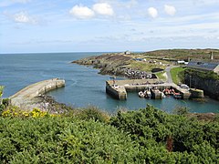 Amlwch Port | |
 Amlwch Location within Anglesey | |
| Area | 18.19 km2 (7.02 sq mi) |
| Population | 3,789 (2011) |
| • Density | 208/km2 (540/sq mi) |
| OS grid reference | SH4492 |
| Community |
|
| Principal area | |
| Ceremonial county | |
| Country | Wales |
| Sovereign state | United Kingdom |
| Post town | AMLWCH |
| Postcode district | LL68 |
| Dialling code | 01407 |
| Police | North Wales |
| Fire | North Wales |
| Ambulance | Welsh |
| UK Parliament | |
| Senedd Cymru – Welsh Parliament | |

Amlwch (/ˈæmlʊx/; Welsh: [ˈamlʊχ]) is the most northerly town in Wales and is a community. It is situated on the north coast of the Isle of Anglesey, on the A5025 which connects it to Holyhead and to Menai Bridge. As well as Amlwch town and Amlwch Port, other settlements within the community include Burwen, Porthllethog/Bull Bay and . The town has a beach in Llaneilian, and it has significant coastal cliffs. Tourism is an important element of the local economy. At one time it was a booming mining town that became the centre of a vast global trade in copper ore. The harbour inlet became a busy port and significant shipbuilding and ship repair centre, as well as an embarkation point with boats sailing to the Isle of Man and to Liverpool. The community covers an area of about 18 square kilometres.[1]
The town[]
The name Amlwch – a reference to the site of the town's harbour, Porth Amlwch – derives from Welsh am ("about, on or around") and llwch (an old word meaning "inlet, creek" - similar to the Gaelic word "loch" for a body of water).[2]
On 23 November 1981, the first tornado of the record-breaking 1981 United Kingdom tornado outbreak, an F1/T2 tornado, passed through Amlwch.
At the 2011 census the community had a population of 3,789.[3]
It is also home to the local secondary school, Ysgol Syr Thomas Jones which Lemmy attended, and the town also has a primary school.
The local newspaper for northeastern Anglesey is Yr Arwydd ('The Sign'). Yr Arwydd is the local Welsh name for Mynydd Bodafon, the paper covers the area surrounding the mountain, and has an image of the summit as its logo.
Industry[]
Amlwch grew rapidly in the 18th century near what was then the world's biggest copper mine at the nearby Parys Mountain. By the late 18th century, Amlwch had a population of around 10,000 and was the second largest town in Wales after Merthyr Tydfil. It was at this time that its harbour was also extended to accommodate the ships needed to transport the ore.
When the copper production declined, a wide variety of industrial activities were developed to take its place. Ship-building in the narrow harbour area and other sites around the coast of Amlwch Port was a significant enterprise from the 1820s and grew in significance after the railway opened in 1864, reducing the use of the harbour for copper and other goods by ship. By 1912 the main shipbuilding activities were in decline, and neither the harbour nor shipyards offered much commercial activity.[4]
In the 1970s, Amlwch had an offshore single point mooring - Amlwch Oil Terminal - which was used to receive large oil tankers which were unsuitable for the Mersey.[5] Reception tanks were located ashore and the oil was pumped from there to the refineries on the Manchester Ship Canal. The terminal closed in 1990.
When copper mining began to decline in the mid-1850s, shipbuilding became the main industry with many people also becoming involved in the ship repair and other maritime industries. The town was home to a brewing industry and also had tobacco works, producing the famous Amlwch Shag Tobacco - "Baco Shag Amlwch".
Pubs in the area include the King's Head, the Queen's Head, the Mariner, the Dinorben Arms Hotel and the Market Tavern in the town, and the Liverpool Arms and the Adelphi Vaults down in the port area.
Railway[]
Amlwch station was the northern terminus of the Anglesey Central Railway which was opened in 1864. It closed to passengers a hundred years later, in 1964, but for the next 30 years was used by freight trains. In 1951 the Amlwch Octel bromide works installed an extension to the line from Amlwch station into their premises. After the passenger service ceased the line continued until 1993 with freight trains bringing sulphuric acid in to the Octel works, and transporting Bromine and related products used in fuel additives, back to the main line, bound for Ellesmere Port.[6]
In 1993 the freight activity was all transferred to road vehicles, and use of the line ceased. The rails were not lifted however, leaving open the prospect that the line could be restored as a tourist and local transport facility for Amlwch, Llanerchymedd and Llangefni. In 2012 a local enthusiast group, Anglesey Central Railway, or Lein Amlwch, were granted permission to clear and survey the line condition,[7] and in May 2017 the Welsh Government announced that re-opening Llangefni station was under active consideration, raising a strong hope that the service could one day continue north to reach Amlwch again.[8]

Tourism[]
Attractions in Amlwch include its restored port area, the Anglesey Coastal Path which passes through it, its watch tower containing an exhibition by Geo Môn, maritime and copper mining museums, St Eleth's Church (which dates from 1800) and the reinforced concrete Catholic church Our Lady Star of the Sea and St Winefride, built in 1937.
Governance[]
Amlwch is in the Twrcelyn electoral ward which also includes Llanbadrig, Llaneilian and Rhosybol, electing three county councillors to the Isle of Anglesey County Council.[9] Prior to the 2012 Anglesey electoral boundary changes the town was represented by two county councillors elected from two wards, Amlwch Port and .
Amlwch has a community council, , comprising fifteen community councillors elected from the three community wards of Town, Rural and Amlwch Port.[10]
Sport and Leisure[]
The town's leisure centre is one of the few on Anglesey and has a swimming pool, sports centre and squash courts. It is situated on Anglesey's 125-mile stretch of coast that is designated Area of Outstanding Natural Beauty.
The town also has two football clubs, Amlwch Town F.C., who play in the Welsh Alliance League, and Amlwch Port F.C., a Sunday League pub team that plays in the North Wales Sunday League.
Amlwch has a sea rowing club based in Bull Bay, Trireme Ynys Mon Rowing Club.
Notable people[]
- Billy Butler (born 1942), radio and television presenter
- William Edwards, Labour politician, born in Amlwch (1938–2007)[11]
- Lemmy attended Ysgol Syr Thomas Jones
- William Roos (1808–1878), artist and engraver
- Andy Whitfield (1971–2011), actor
- Keith Paul Mills (born 1959), Captain Keith Paul Mills, DSC, British Royal Marines officer who commanded the defence of South Georgia against the 1982 Argentine[12][circular reference]
References[]
- ^ UK Census (2011). "Local Area Report – Amlwch Parish (W04000002)". Nomis. Office for National Statistics. Retrieved 25 August 2020.
- ^ BBC Wales: What's in a name?
- ^ "Parish Headcounts: Isle of Anglesey". Neighbourhood Statistics. Office for National Statistics. Archived from the original on 13 June 2011. Retrieved 20 March 2013.
- ^ "Ship Building". Amlwch History. Archived from the original on 3 March 2016. Retrieved 28 November 2017.
- ^ Anglesey Marine Terminal
- ^ Neil Summers. "Octel Bromine Works, Amlwch". www.octelamlwch.co.uk. Retrieved 28 November 2017.
- ^ "Anglesey railway track clear-up brings Gaerwen-Amlwch reopening closer". BBC North West Wales. 19 April 2012. Retrieved 28 November 2017.
- ^ "Anglesey's 'ghost railway' could re-open for first time in more than 50 years". Daily Post. May 2017.
- ^ "Isle of Anglesey (Electoral Arrangements) Order 2012" (PDF). legislation.gov.uk. The National Archives. Retrieved 3 December 2017.
- ^ "Councillors". Cyngor Tref Amlwch. Retrieved 3 December 2017.
- ^ "Obituaries: Will Edwards, Labour MP in rural Wales". The Independent. 27 August 2007.
- ^ Keith Mills (Royal Marines officer)
External links[]
| Wikivoyage has a travel guide for Amlwch. |

| show Authority control |
|---|
- Amlwch
- Towns in Anglesey