Anahim Peak
| Anahim Peak | |
|---|---|
| Bes But'a | |
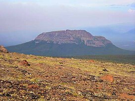 West side of Anahim Peak | |
| Highest point | |
| Elevation | 1,897 m (6,224 ft)[1] |
| Prominence | 542 m (1,778 ft)[1] |
| Coordinates | 52°45′28″N 125°37′31″W / 52.75778°N 125.62528°WCoordinates: 52°45′28″N 125°37′31″W / 52.75778°N 125.62528°W[2] |
| Geography | |
 Anahim Peak | |
| District | Range 3 Coast Land District |
| Parent range | Chilcotin Plateau |
| Topo map | NTS 92C13 Ucluelet |
| Geology | |
| Age of rock | 6.7 million years[3] |
| Mountain type | Volcanic plug |
| Volcanic belt | Anahim Volcanic Belt |

Anahim Peak, sometimes mistakenly called Anaheim, is a volcanic cone in the Anahim Volcanic Belt in British Columbia, Canada, located 39 km (24 mi) northwest of Anahim Lake and 11 km (7 mi) east of Tsitsutl Peak.[1][2] It was formed when the North American Plate moved over a hotspot, similar to the one feeding the Hawaiian Islands, called the Anahim hotspot. It is one of the several volcanoes in the Anahim Volcanic Belt that stands out all by itself, rising from the Chilcotin Plateau, between the Rainbow Range and the Ilgachuz Range and near the headwaters of the Dean River.
Name[]
The Carrier (Dakelh) name for Anahim Peak is Bes But'a, meaning "obsidian peak";[4] the word bes occurs in local English as "beece", another word for obsidian and also an early designation for this mountain, although today's is not nearby but rather near Taseko Mountain some distance to the southeast. The name Anahim is that of , a leader of the Tsilhqot'in people in the mid-19th Century.
Area and history[]
Anahim Peak was a significant source of obsidian for the Nuxalk, Tsilhqot'in, and Dakelh peoples. Obsidian was desirable because extremely sharp arrowheads and cutting knives could be made from it. It was also used for jewellery. Anahim obsidian was traded widely all over the BC Interior and up and down the Coast from Bella Coola. Red ochre was used in paint and decoration was also taken from this area. Anahim Peak is not far from the small community of Anahim Lake.
See also[]
- List of volcanoes of Canada
- Anahim hotspot
- Anahim Volcanic Belt
- Volcanism in Canada
- Anahim (disambiguation)
References[]
- ^ a b c "Anahim Peak". Bivouac.com. Retrieved 2007-03-18.
- ^ a b "Anahim Peak". BC Geographical Names. Retrieved 2009-01-13.
- ^ Bevier, Mary Lou (1978). Field Relations and Petrology of the Rainbow Range Shield Volcano, West-Central British Columbia (M.S. Thesis). University of British Columbia. p. 68. Retrieved 2021-01-16.
- ^ "Dakelh placenames". Yinka Dene Language Institute. Retrieved 2009-11-20.
- Anahim Volcanic Belt
- Volcanic plugs of British Columbia
- Miocene volcanoes
- One-thousanders of British Columbia
- Landforms of the Chilcotin
- Polygenetic volcanoes
- Range 3 Coast Land District