Andahuaylas Airport
Andahuaylas Airport | |||||||||||
|---|---|---|---|---|---|---|---|---|---|---|---|
 | |||||||||||
| Summary | |||||||||||
| Airport type | Public | ||||||||||
| Operator | CORPAC S.A. | ||||||||||
| Serves | Andahuaylas | ||||||||||
| Elevation AMSL | 11,300 ft / 3,444 m | ||||||||||
| Coordinates | 13°42′30″S 73°21′05″W / 13.70833°S 73.35139°WCoordinates: 13°42′30″S 73°21′05″W / 13.70833°S 73.35139°W | ||||||||||
| Map | |||||||||||
 ANS Location of airport in Peru | |||||||||||
| Runways | |||||||||||
| |||||||||||
Sources: GCM[1] | |||||||||||

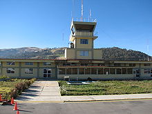
Andahuaylas Airport (IATA: ANS, ICAO: SPHY) is a high-elevation airport serving Andahuaylas, Peru. It is an important airport in the Apurímac Region as being the only one with scheduled commercial flights. It is operated by the civil government. Apart from its scheduled flights, it also has many charter flights.
The airport is 6 kilometres (3.7 mi) southeast of Andahuaylas, and sits on a mesa above the , which continues north and west into the town. There is high terrain in all quadrants.
Airlines and destinations[]
| Airlines | Destinations |
|---|---|
| Star Perú | Lima |
See also[]
- Transport in Peru
- List of airports in Peru
- List of highest commercial airports
References[]
- ^ Airport information for ANS at Great Circle Mapper.
External links[]
This article about an airport in Peru is a stub. You can help Wikipedia by . |
Categories:
- Airports in Peru
- Buildings and structures in Apurímac Region
- Peruvian airport stubs