Anibare District
This article does not cite any sources. (December 2009) |
Anibare | |
|---|---|
District | |
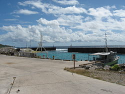 Anibare Harbour | |
 Anibare District within Nauru | |
| Coordinates: 0°31′50″S 166°56′40″E / 0.53056°S 166.94444°ECoordinates: 0°31′50″S 166°56′40″E / 0.53056°S 166.94444°E | |
| Country | |
| Constituency | Anabar |
| Area | |
| • Total | 3.1 km2 (1.2 sq mi) |
| Elevation | 30 m (100 ft) |
| Population (2011) | |
| • Total | 226 |
| Time zone | (UTC+12) |
| Area code(s) | +674 |

Anibare is a district in the island nation Nauru, a part of the Anabar Constituency.
Geography[]
It is located in the east of the island, and covers an area of 3.1 km2 (1 sq mi). It has a population of about 250. It is thus Nauru's largest district in area, and among the smallest in population. Nauru's reputation for being densely populated is thus somewhat nuanced, since it refers principally to the average areas and populations of districts other than Anibare.
Local features[]
- Anibare Bay. A beach with white coral sand near the Menen Hotel which is considered the best place on the island to surf or to swim. It also contains the Anibare Harbor, an artificial commercial fishing area.
- A Phosphate stockpile is located in western Anibare.
See also[]
References[]
External links[]
![]() Media related to Anibare at Wikimedia Commons
Media related to Anibare at Wikimedia Commons
| History |  | ||||||
|---|---|---|---|---|---|---|---|
| Geography |
| ||||||
| Politics | |||||||
| Economy |
| ||||||
| Society |
| ||||||
This Nauruan location article is a stub. You can help Wikipedia by . |
Categories:
- Districts of Nauru
- Populated places in Nauru
- Nauru stubs
- Oceania geography stubs