Annaberg-Lungötz
Annaberg-Lungötz | |
|---|---|
 | |
 Coat of arms | |
 Annaberg-Lungötz Location within Austria | |
| Coordinates: 47°31′00″N 13°25′00″E / 47.51667°N 13.41667°ECoordinates: 47°31′00″N 13°25′00″E / 47.51667°N 13.41667°E | |
| Country | Austria |
| State | Salzburg |
| District | Hallein |
| Area | |
| • Total | 61.04 km2 (23.57 sq mi) |
| Elevation | 777 m (2,549 ft) |
| Population (2018-01-01)[2] | |
| • Total | 2,203 |
| • Density | 36/km2 (93/sq mi) |
| Time zone | UTC+1 (CET) |
| • Summer (DST) | UTC+2 (CEST) |
| Postal code | 5524 Annaberg, 5523 Lungötz |
| Area code | 06463 |
| Vehicle registration | HA |
| Website | www.annaberg-lungoetz.at |

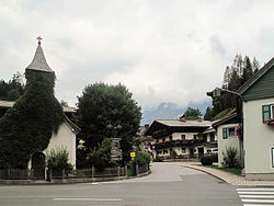
Annaberg-Lungötz is a municipality in the district of Hallein, in the Austrian state of Salzburg.
Geography[]
The municipality lies in the Lammer River valley at the foot of the Gosaukamm.
History[]
It belonged for centuries to the Pongau. Only in 1896, when Hallein became a district capital, did the municipality become part of the Tennengau.
Tourism[]
One of its subdivisions, Annaberg im Lammertal is a village especially notable for tourism. Located in the Alps, it is part of the Dachstein West ski region. Summer activities available for tourists include mountain biking, paragliding, white water rafting, etc.
References[]
- ^ "Dauersiedlungsraum der Gemeinden Politischen Bezirke und Bundesländer - Gebietsstand 1.1.2018". Statistics Austria. Retrieved 10 March 2019.
- ^ "Einwohnerzahl 1.1.2018 nach Gemeinden mit Status, Gebietsstand 1.1.2018". Statistics Austria. Retrieved 9 March 2019.
External links[]
| Authority control |
|---|
This Salzburg state location article is a stub. You can help Wikipedia by . |
Categories:
- Tennen Mountains
- Dachstein Mountains
- Cities and towns in Hallein District
- Salzburg geography stubs