Ano Doliana
Ano Doliana
Άνω Δολιανά | |
|---|---|
 Historical and Ethnographical Museum of Doliana | |
 Ano Doliana show North Kynouria municipality | |
| Coordinates: 37°23′10″N 22°29′53″E / 37.386°N 22.498°E | |
| Country | Greece |
| Administrative region | Peloponnese |
| Regional unit | Arcadia |
| Municipality | North Kynouria |
| Elevation | 1,000 m (3,000 ft) |
| Community | |
| • Population | 90 (2011) |
| Time zone | UTC+2 (EET) |
| • Summer (DST) | UTC+3 (EEST) |
| Postal code | 220 13 |
| Area code(s) | +30 271 |


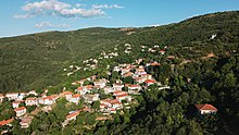
Ano Doliana (Ano meaning "upper", Greek: Άνω Δολιανά, Greek pronunciation: [ano ðolianaː]) or simply Doliana, is a stone-built mountainous village in the municipality of North Kynouria, in eastern Arcadia, Greece.[2] As of 2011 it had 90 inhabitants. It is a protected traditional settlement.[3][4]
It used to be the main residence of the settlers, but nowadays only a handful of them stay throughout the year, as most use it as their summer residence and instead overwinter in Kato Doliana because of the milder climate.[5] In recent years it has emerged as a relatively popular tourist destination, with a significant number of visitors, especially during the winter season weekends.
Location[]
The settlement is located on the southern outskirts of the plain of Tripoli. It extends at an altitude of 950 to 1.050 meters, built amphitheatrically on the northern slopes of mount Parnon, filled with fir, chestnut, platanus and cherry trees, surrounded by creeks and small waterfalls. The village is spread in two neighborhoods and overlooks the plateau of Tripoli, with the visual horizon reaching the mountains of Mainalo, , Helmos and Erymanthos.
Flora[]
The village is overgrown with chestnut and platanus trees, while a natural fir forest starts at its northeastern tip. Sweet cherry trees thrive in the area, while there are sour cherry trees as well. One can also see apple trees, walnut trees, oak trees, almond-leaved pear trees, but also some hazel trees and pear trees, in a spectacle that is particularly interesting during autumn foliage of deciduous trees, fit for leaf peeping.[6][7]
The area is also home to various species of mushrooms.
Fauna[]
The fauna of the area consists of a plethora of non-migratory birds such as: European goldfinches, common blackbirds, Old World sparrows, true finches, white wagtails, calandra larks, European greenfinches and larks. Migratory birds that visit the area are: European turtle doves, common nightingales, swallows, Eurasian golden orioles and Eurasian hoopoes during spring throughout summer, but also thrushes and European robins during winter.
Mammals include European hares, martens and bats. Wild boars have reappeared in recent years, while European roe deers (Capreolus capreolus) are an even more recent reintroduction to mount Parnon, following their disappearance from the area in the early 20th century.[8]
Other species in the area include reptiles such as snakes (vipers, common European adders, Balkan whip snakes and others), Mediterranean house geckos and lizards. Finally, arthropods such as scorpions and spiders can often be found.
History[]
The village was established as the primary residence of the settlers, who were mainly shepherds, leaving a pastoral life and herding livestock around open areas of land. Therefore, they settled on the mountains. Doliana was used as a secondary settlement, in which the inhabitants migrated during the winter months to protect the animals from low temperatures and snow. At the same time, the mountain pastures were given time to rejuvenate. But with the modernization of life and the transformation of the main occupation of the inhabitants from livestock to cultivation, especially olive oil trees, the roles of the two settlements were reversed. Over the years and because of the abandonment of its role as a basic settlement of the inhabitants, the village has managed to maintain its graphic character relatively intact, avoiding the extensive human interventions of the modern era.
Ancient quarries[]
Ancient marble quarries are located northwest of the community, dating back to the archaic-classical era. The homonymous Doliana marble[9] was and is still being extracted here. It is white in color, with a tone of light blue or blue.[10][11] It is one of the highest quality marbles in the Peloponnese, showing similarities with the Pentelic marble of Attica, although it does not reach the qualitative characteristics of the latter.[12] It was most primarily used as a building block in antiquity and rarer in sculpture.
Among others, it has been used in the following cases:
- Temple of Athena Alea.[13]
- Villa of Herodes Atticus.[11]
- Ancient Olympia, mainly for sculpture.[14]
- Epidaurus.[14]
- Mantineia Base.[15]
Greek revolution[]

During the Greek War of Independence, a battle against the Turks took place in the village on 18 May 1821, known as the Battle of Doliana which was victorious for the Greeks.
In this battle, Nikitaras with 300 men, managed to repel 4.000 Turks that attacked the village with artillery. It was on this day that he took on the nickname "Turkophagos" which later accompanied him, because according to tradition many of the opponents died of his hands. At the entrance of Doliana and specifically at the point where the main battle unfolded, named "Tsakonas ravine", a honorable bust of Nikitaras has been erected.
Information[]
Traditionally, the main repatriation of the inhabitants of Kato Doliana, as well as internal migrants and expatriates, takes place the week of the feast of Virgin Mary. Especially on the eve and on the day of 14 and 15 August, the concentration of Dolianites (as they call themselves) in the settlement is peaking. During this time folk festivals and other events take place, such as a traditional feast on the central square, movie screenings, as well as Youth Festivals at the chapel of Saint John located on a slope that faces the village.[16][17][18]

Ancient marble quarries can be found in the vicinity of the community, producing the homonymous "Doliana marble",[19] which was used -among others- in the construction of the Temple of Apollo Epicurius of Bassae, the Temple of Athena Alea in Tegea and possibly the Mantineia Base.
The mountain top of Saint Elias, a name often given to mountain tops in Greece, rises above the village. Here, on 20 July, residents gather in the homonymous chapel, at an altitude of 1.280 meters and perform a liturgy. Due to its high altitude of 1.390 meters, it is also being used as a telecommunications hub for the wider region, with antennas transmitting signals for OTE, television, radio and mobile telephony. It is accessible by a 4 km long road that starts from Doliana.[20][21]


Demographic evolution[]
| Year | Population | Population diagram |
|---|---|---|
| 1834 | 893 | |
| 1861 | 1,336[22] | |
| 1870 | 1,323 | |
| 1879 | 1.682[23] | |
| 1889 | 1.577[24] | |
| 1896 | 1,649[25] | |
| 1907 | 1,627 | |
| 1920 | 1,849 | |
| 1928 | 1,796 | |
| 1940 | 1,594 | |
| 1951 | 66 | |
| 1961 | 12 | |
| 1971 | 6 | |
| 1981 | 19 | |
| 1991 | 69 | |
| 2001 | 80 | |
| 2011 | 90 |
Sights[]
On 23 May 2015, the "Historical and Ethnographical Museum of Doliana" was inaugurated, dedicated to the historic battle that took place in the village, but also to the wider folklore of everyday life in the area. It is located in Christofili's house, which was the house where Nikitaras and his klephts fort upped during the battle, thus it was named "To tampouri tou Nikitara" (i.e. "The bulwark of Nikitaras").[26][27] It is open to the public every Saturday and Sunday morning and is admission free.[28]
The old elementary school is of particular interest, as it has been declared a traditional building by the Ministry of Environment and Physical Planning and today operates as a traditional guesthouse.[29] As a school, it used to operate during September and October of each school year, until the farmers would complete the harvest of chestnuts and other crops and move to the lowland settlement. It ceased its operation in October 1982.
Events[]
In late October to early November, when the chestnut harvest from the trees that abound in the surrounding area is completed, the community organizes the so-called "Yorti Kastanou" (i.e. "Chestnut Feast") where visitors have the opportunity to enjoy chestnut in many different recipes for food, sweets and liqueurs.[30]
On 23 April, along with the return of part of the settlers for the warm days of the year, the icon of the patron saint of the village, Agios Georgios, is transferred here from the village of Kato Doliana by bus. On the first Sunday of November the icon returns to the lowland settlement.[31][32] During the descent, the residents hand-carry the icon on a ritual hike that lasts several hours and passes through the old path that used to connect the two settlements before motorways were created.[33]
In the past, the local Cultural Association organized the so-called "Representation of the Battle of Doliana". It took place every four years in honor of the Greek revolution fighters and was attended by almost all residents of the village. The custom has diminished over the years, taking place for the last time in 2003. Nowadays it is limited to a simple ritual event of remembrance.[34] The representation of the battle is expected to revive in 2021, on its 200 years anniversary.[35]
Sports[]

Since 2015, an annual mountain half marathon takes place, usually between late May to mid-June, alongside a 5 km race for less experienced runners and a 1000m race for children. It is an event that has been upgraded since 2017 and is under the auspices of SEGAS, Greece's governing body for amateur sports.[36][37]
The village has a grass football field, which is used by local football clubs for their summer pre-season training, as well as an open basketball court.
Activities[]
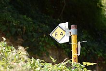
The E4 European long distance path crosses right through Doliana, making it an adequate destination for hikers.[38][39][40]

Lying at the northernmost edge of mount Parnon, Doliana also serve as a starting point for Parnon Trail, a trekking path 200 kilometres long that is based on old paths of the region and is currently under revival works by local volunteer groups. It crosses the whole Parnon range throughout the wider area of Cynuria, combining the mountain and the sea along its path.[41][42]

At an altitude of 1,100 meters and on the highest edge of the village, an artificial environmental settlement has been built by the local forestry authority with funding from the Ministry of Agricultural Development. It is known as dasiko horio (literally translating to forest village) by the locals. Its construction was part of the Ministry's broader effort to create infrastructure in remote mountainous forest regions of Greece, to facilitate short-term visitor stay in relative comfort close to the forest, for recreational and educational purposes.[43] It consists of 20 wooden residences that are spread on an area of 29 acres and can accommodate up to 80 guests.[44]
A chalet, perched at an altitude of 1,090 meters, is the epicenter of Dasiko Horio, offering panoramic views of the Tripoli plateau and the surrounding region. A small theatre, built out of stone in 2000, is also located near the premises.
See also[]
| Wikimedia Commons has media related to Ano Doliana. |
| Wikivoyage has a travel guide for Ano Doliana. |
- Battle of Doliana
- Kato Doliana, the lowland residency of the settlers
- Parnon
- Forest villages (Greece)
- List of traditional settlements of Greece
- List of settlements in Arcadia
External links[]
- Parnon Trail website
- Run Doliana – Mountain half-marathon (in Greek)
- Doliana Patriotic Association
- Meteology.gr – Doliana meteo webcam
References[]
- ^ Jump up to: a b "Απογραφή Πληθυσμού - Κατοικιών 2011. ΜΟΝΙΜΟΣ Πληθυσμός" (in Greek). Hellenic Statistical Authority.
- ^ ExploringGreece – Ano Doliana (Village) ARKADIA, NORTH KINURIA
- ^ Υπουργείο Περιβάλλοντος, Ενέργειας και Κλιματικής Αλλαγής – Αρχείο Παραδοσιακών Οικισμών & Διατηρητέων Κτιρίων – Φ.Ε.Κ. Δ-908 α/ 13.11.1998 Υ.ΠΕ.ΧΩ.Δ.Ε. (in Greek)
- ^ Υπουργείο Περιβάλλοντος, Ενέργειας και Κλιματικής Αλλαγής – Αρχείο Παραδοσιακών Οικισμών & Διατηρητέων Κτιρίων – Φ.Ε.Κ. Δ-1081 α/ 13.10.2003 Υ.ΠΕ.ΧΩ.Δ.Ε. (in Greek)
- ^ Kato Doliana, Ano Doliana, Regional Guide of Peloponnese
- ^ "Περιήγηση στα Άνω Δολιανά". www.discoverkynouria.gr (in Greek). 18 July 2013. Retrieved 27 November 2019. (in Greek)
- ^ 5ente – Πεζοπορία (in Greek)
- ^ "Fauna". Management Body of Mount Parnon and Moustos Wetland (in Greek). Retrieved 12 July 2020.
- ^ "The Arcadia Website – Δικτυακός Τόπος ΑΡΚΑΔΙΑ, University of Patras – Δολιανά". Archived from the original on 16 December 2000. Retrieved 23 April 2017. (in Greek)
- ^ National and Kapodistrian University of Athens: Department of History and Archaeology – Corpus of Ancient Quarries (in Greek)
- ^ Jump up to: a b Department of Archaeology and Art History of the University of Athens – Corpus of Ancient Quarries, p. 164 (in Greek)
- ^ Richard Lepsius: Griechische Marmorstudien. Königlich Preussische Akademie der Wissenschaften zu Berlin vom Jahre 1890, p. 31-34, 112. (in German)
- ^ Ministry of Culture and Sports _ Temple of Athena Alea
- ^ Jump up to: a b "Region Guide of Peloponnisos". cultureportal.uop.gr. 13 July 2020. Retrieved 13 July 2020.
- ^ Polihroniou, Anna Ioanni (15 October 2010). "Investigation of the origin of ancient marbles from Olympia with physicochemical techniques". Aristotle University of Thessaloniki Institutional Repository – IKEE (in Greek). Retrieved 13 July 2020.
- ^ Astros News – «Όνειρα Θερινής Νυκτός» 2019 (in Greek)
- ^ Kalimera Arkadia – Κινηματογραφικό Φεστιβάλ στα Άνω Δολιανά (in Greek)
- ^ Arcadia Portal – Η Κατερίνα Στανίση στα Άνω Δολιανά (in Greek)
- ^ The Arcadia Website – Δικτυακός Τόπος ΑΡΚΑΔΙΑ, University of Patras – Δολιανά Archived 16 December 2000 at the Wayback Machine (in Greek)
- ^ Kalimera Arkadia – Άνω Δολιανά _ Γιορτή του Προφήτη Ηλία ... σε υψόμετρο 1.250 μέτρα (in Greek)
- ^ Astros News – Εσπερινός στον Αϊ Λια στα Άνω Δολιανά (in Greek)
- ^ Στατιστική της Ελλάδος – Πληθυσμός του έτους 1861 (in Greek)
- ^ Εργαστήριο Δημογραφικών και Κοινωνικών Αναλύσεων Πανεπιστημίου Θεσσαλίας – Εργο e-Demography – Εκδόσεις ΕΛΣΤΑΤ – Απογραφές – 1879 (in Greek)
- ^ Εργαστήριο Δημογραφικών και Κοινωνικών Αναλύσεων Πανεπιστημίου Θεσσαλίας – Εργο e-Demography – Εκδόσεις ΕΛΣΤΑΤ – Απογραφές – 1889 (in Greek)
- ^ Εργαστήριο Δημογραφικών και Κοινωνικών Αναλύσεων Πανεπιστημίου Θεσσαλίας – Εργο e-Demography – Εκδόσεις ΕΛΣΤΑΤ – Απογραφές – 1896 (in Greek)
- ^ Το ΑrcadiaPortal σας ξεναγεί στο Ιστορικό και Εθνογραφικό Μουσείο Δολιανών (in Greek)
- ^ Arcadia Portal – Ανακαλύψτε το ταμπούρι του Νικηταρά στα Άνω Δολιανά (in Greek)
- ^ Δημοτική Ραδιοφωνία Τρίπολης – Κάθε Σαββατοκύριακο ανοιχτό το "Ταμπούρι του Νικηταρά" στα Άνω Δολιανά (in Greek)
- ^ Υπουργείο Περιβάλλοντος, Ενέργειας και Κλιματικής Αλλαγής – Αρχείο Παραδοσιακών Οικισμών & Διατηρητέων Κτιρίων – ΦΕΚ Δ-133 α/14.03.1995 (in Greek)
- ^ arcadiaportal.gr – Γιορτή Κάστανου με άφθονα κάστανα, γλέντι και όμορφη θέα στα Άνω Δολιανά (in Greek)
- ^ astros-kynourianews.gr – Η μεταφορά της εικόνας του Αϊ Γιώργη των Δολιανών ,από τα Άνω στα Κάτω Δολιανά (in Greek)
- ^ DiscoverKynouria.gr – Μεταφορά της εικόνας του Αγίου Γεωργίου από τα Άνω στα Κάτω Δολιανά (in Greek)
- ^ Parnon Trail – Dragouni–Korytes
- ^ arcadiaportal.gr – Η 192η επέτειος της Μάχης των Βερβένων (photos & video) (in Greek)
- ^ kalimera-arkadia.gr – Κάτοικοι των Άνω Δολιανών με παραδοσιακές φορεσιές στις εκδηλώσεις για τη Μάχη (in Greek)
- ^ segas.gr – Αγωνιστικό πρόγραμμα δρόμων σε δημόσιο δρόμο και βουνού – 2017 Archived 19 May 2017 at the Wayback Machine (in Greek)
- ^ segas.gr – Αγωνιστικό πρόγραμμα δρόμων σε δημόσιο δρόμο και βουνού – 2019 (in Greek)
- ^ Waymarked Trails – Hiking – E4 Ano Doliana
- ^ 5ente – Hiking
- ^ Just for one summer – Wandering around Ano Doliana
- ^ Parnon Trail – The dream comes true!
- ^ Parnon Trail – The first groups of volunteers to join to connect the paths of Kynouria with the Menalon Trail, were formed…
- ^ Υπουργείο Αγροτικής Ανάπτυξης & Τροφίμων – Δασικά Χωριά (in Greek)
- ^ Υπουργείο Αγροτικής Ανάπτυξης & Τροφίμων – ΔΑΣΙΚΟ ΧΩΡΙΟ "ΑΝΩ ΔΟΛΙΑΝΑ" (in Greek)
- Populated places in Arcadia, Peloponnese