Antigo Air Force Station
This article includes a list of general references, but it remains largely unverified because it lacks sufficient corresponding inline citations. (December 2012) |
Antigo Air Force Station | |
|---|---|
| Part of Air Defense Command (ADC) | |
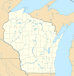
| South-southwest of Antigo, Wisconsin | |
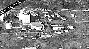 USAF photo, 14 January 1972 | |
| Coordinates | 45°02′54″N 089°14′02″W / 45.04833°N 89.23389°W |
| Type | Air Force Station |
| Code | ADC ID: P-19, NORAD ID: Z-19 |
| Site information | |
| Controlled by | |
| Site history | |
| Built | 1951 |
| In use | 1951-1977 |
| Garrison information | |
| Garrison | 676th Aircraft Control and Warning Squadron |


Antigo Air Force Station is a closed United States Air Force General Surveillance Radar station. It is located 7.5 miles (12.1 km) south-southwest of Antigo, Wisconsin. It was closed in 1977 and is currently classified as a high risk toxic waste site involving groundwater, sediment, soil and surface water.[1][2]
History[]
In late 1951 Air Defense Command selected Antigo, Wisconsin site as one of twenty-eight radar stations built as part of the second segment of the permanent radar surveillance network. Prompted by the start of the Korean War, on July 11, 1950, the Secretary of the Air Force asked the Secretary of Defense for approval to expedite construction of the second segment of the permanent network. Receiving the Defense Secretary's approval on July 21, the Air Force directed the Corps of Engineers to proceed with construction.
On 1 May 1951 the 676th Aircraft Control and Warning Squadron began operating an AN/FPS-3 search radar and an AN/FPS-4 height-finder radar in June 1952, and initially the station functioned as a Ground-Control Intercept (GCI) and warning station. As a GCI station, the squadron's role was to guide interceptor aircraft toward unidentified intruders picked up on the unit's radar scopes. At the end of 1958 Antigo was operating an AN/FPS-20 search radar and an AN/FPS-6 height-finder radar. A second AN/FPS-6B height-finder radar was added in 1959.
During 1960 Antigo AFS joined the Semi Automatic Ground Environment (SAGE) system, initially feeding data to DC-14 at K. I. Sawyer AFB, Michigan. After joining, the squadron was re-designated as the 676th Radar Squadron (SAGE) on 15 July 1960. The radar squadron provided information 24/7 the SAGE Direction Center where it was analyzed to determine range, direction altitude speed and whether or not aircraft were friendly or hostile. In June 1963, the SAGE feed was switched to DC-12 at McChord AFB. In October 1963, the data feed was switched to DC-10 at Duluth AFS, Minnesota and in June 1964 to DC-07 at Truax Field, Wisconsin.
During 1962 an AN/FPS-35 replaced the AN/FPS-20 set. On 31 July 1963, the site was redesignated as NORAD ID Z-19. The AN/FPS-6B was modified to an AN/FPS-90 in 1964. The AN/FPS-6 was also modified to an AN/FPS-90 in 1966. One AN/FPS-90 was retired in 1969.
In addition to the main facility, Antigo operated the following AN/FPS-18 Gap Filler sites:
- Norway, MI (P-19A) 45°47′19″N 087°52′06″W / 45.78861°N 87.86833°W
- Two Creeks AFS, WI (P-19B) 44°19′25″N 087°34′47″W / 44.32361°N 87.57972°W
- Brooks, WI (P-19C) 43°49′39″N 089°42′54″W / 43.82750°N 89.71500°W
Over the years, the equipment at the station was upgraded or modified to improve the efficiency and accuracy of the information gathered by the radars.
In March 1977 the Air Force announced that the station would be closing due to what was called "redundancies with more strategically located radars". The 676th Radar Squadron (SAGE) was inactivated on 30 June 1977, and the facility was closed.
Today, Antigo Air Force Station remains abandoned, badly deteriorating 30 years after its inactivation.
Toxic site[]
The United States Department of Defense classifies Antigo Air Force Station as a toxic waste site of high concern, involving both toxins and radiation.[1]
Air Force units and assignments[]
Units[]
- Established as 676th Aircraft Control and Warning Squadron
- Activated on 1 May 1951
- Redesignated 676th Radar Squadron (SAGE) on 15 July 1960
- Redesignated 676th Radar Squadron on 1 February 1974
- Inactivated on 30 June 1977
Assignments[]
- 543d Aircraft Control and Warning Group, 1 May 1951
- 31st Air Division, 6 February 1952
- Eastern Air Defense Force
- 4706th Defense Wing, 16 February 1953
- 37th Air Division, 8 July 1956
- 30th Air Division, 1 April 1959
- Sault Sainte Marie Air Defense Sector, 1 April 1960
- Duluth Air Defense Sector, 1 October 1963
- Chicago Air Defense Sector, 1 June 1964
- 20th Air Division, 1 April 1966
- 30th Air Division, 1 December 1967
- 34th Air Division, 1 July 1968
- 29th Air Division, 14 November 1969 – 30 June 1977
See also[]
References[]
![]() This article incorporates public domain material from the Air Force Historical Research Agency website http://www.afhra.af.mil/.
This article incorporates public domain material from the Air Force Historical Research Agency website http://www.afhra.af.mil/.
- ^ a b "Bombs in Your Backyard: ANTIGO AIR FORCE STATION". propublica.org. Archived from the original on 2017-12-01.
- ^ "Property Information Page". rsgisias.crrel.usace.army.mil.
- Cornett, Lloyd H. and Johnson, Mildred W., A Handbook of Aerospace Defense Organization 1946 - 1980, [1] Office of History, Aerospace Defense Center, Peterson AFB, CO (1980).
- Winkler, David F. & Webster, Julie L., Searching the Skies, The Legacy of the United States Cold War Defense Radar Program, [2] US Army Construction Engineering Research Laboratories, Champaign, IL (1997).
- Information for Antigo AFS, WI
| Bases |
|  | |||||||||||
|---|---|---|---|---|---|---|---|---|---|---|---|---|---|
| Stations | |||||||||||||
| Air Defense units |
| ||||||||||||
| Major weapon systems |
| ||||||||||||
| Miscellaneous |
| ||||||||||||
Coordinates: 45°02′54″N 89°14′02″W / 45.048333°N 89.233889°W
- Installations of the United States Air Force in Wisconsin
- Buildings and structures in Langlade County, Wisconsin
- Semi-Automatic Ground Environment sites
- Aerospace Defense Command military installations
- 1951 establishments in Wisconsin
- 1977 disestablishments in Wisconsin
- Military installations established in 1951
- Military installations closed in 1977