Aqueduct Lock
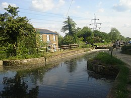 Looking south, the lock and the lock-keeper's cottage | |
| Waterway | River Lee Navigation |
|---|---|
| County | Hertfordshire Essex |
| Maintained by | British Waterways |
| Operation | Manual |
| Length | 85 feet (25.9 m) |
| Width | 16 feet (4.9 m) |
| Fall | 5 feet 6 inches (1.7 m) |
| Distance to Bow Creek | 15.5 miles (24.9 km) |
| Distance to Hertford Castle Weir | 10.8 miles (17.4 km) |
| Coordinates | 51°43′19″N 0°00′51″W / 51.721937°N 0.014299°WCoordinates: 51°43′19″N 0°00′51″W / 51.721937°N 0.014299°W |

Aqueduct Lock (Number 8) is a lock on the River Lee Navigation close to Turnford.
Location[]
The lock is located in the River Lee Country Park and is adjacent to the Old River Lea and the 180-acre (0.73 km2) Holyfield Lake which incorporates part of the River Lee Flood Relief Channel
The aqueduct above the lock carries the Small River Lea under the Navigation, which flows from the nearby Old River Lea.

The aqueduct
Public access[]
Vehicular access at Wharf Road, Wormley car park.
Pedestrian and cycles via the towpath which forms part of the Lea Valley Walk.
Public transport[]
External links[]
Categories:
- Locks of the Lee Navigation
- Locks in Essex
- Locks in Hertfordshire
- Navigable aqueducts in England
- Transport infrastructure completed in 1922