Areopoli
Areopolis
Αρεόπολη | |
|---|---|
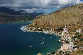 Limeni (port) of Aeropoli | |
 Areopolis | |
| Coordinates: 36°39.95′N 22°22.90′E / 36.66583°N 22.38167°ECoordinates: 36°39.95′N 22°22.90′E / 36.66583°N 22.38167°E | |
| Country | Greece |
| Administrative region | Peloponnese |
| Regional unit | Laconia |
| Municipality | East Mani |
| Municipal unit | Oitylo |
| Elevation | 255 m (837 ft) |
| Community | |
| • Population | 1,014 (2011) |
| Time zone | UTC+2 (EET) |
| • Summer (DST) | UTC+3 (EEST) |
| Postal code | 230 62 |
| Area code(s) | 27330 |
| Vehicle registration | ΑΚ |
| Website | www.dimosoitilou.gr/gr/dd/areopoli/ar.htm |

Areopoli (Greek: Αρεόπολη; before 1912 Τσίμοβα, Tsimova)[2] is a town on the Mani Peninsula, Laconia, Greece.
The word Areopoli, which means "city of Ares", the ancient Greek god of war, became the official name in 1912. It was the seat of Oitylo municipality. The Greek War of Independence was started at Areopoli on March 17, 1821 by Petros Pierrakos, also known as Petros Mavromichalis, the last bey of Mani. Now Areopoli has grown into a flourishing town. Its tower houses, constructed with field stones, are distinct from the traditional blue and white buildings that characterize many Greek villages.


Areopoli is situated near the west coast of the Mani Peninsula, 1.5 km from its port Limeni. It is 20 km southwest of Gytheio. There is lively open air market in the main square each Saturday, with a lot of local producers present.
Historical population[]
| Year | Population |
|---|---|
| 1981 | 738 |
| 1991 | 759 |
| 2001 | 988 |
| 2011 | 1,014 |
Notable people[]
- (1903-1986), poet
- Dimitrios Kalapothakis, journalist
- Stylianos Pierrakos (Stylianos Mavromichalis) (1902–1981), former Prime Minister of Greece
- Georgios Polymenakos, military officer
- (1926-2018), Chancellor of the University of Central Greece
References[]
- ^ a b "Απογραφή Πληθυσμού - Κατοικιών 2011. ΜΟΝΙΜΟΣ Πληθυσμός" (in Greek). Hellenic Statistical Authority.
- ^ EETAA local government changes
See also[]
![]() Media related to Areopoli at Wikimedia Commons
Media related to Areopoli at Wikimedia Commons
This Peloponnese location article is a stub. You can help Wikipedia by . |
- Populated places in the Mani Peninsula
- Populated places in Laconia
- Peloponnese geography stubs