Arkadiko Bridge
Arkadiko Bridge (Kazarma Bridge) | |
|---|---|
 Arkadiko Mycenaean Bridge | |
| Coordinates | 37°35′37″N 22°56′15″E / 37.59363°N 22.937556°E |
| Carries | Mycenaean road Tiryns–Epidauros |
| Locale | Arkadiko, Argolis, Greece |
| Characteristics | |
| Design | Corbel arch bridge |
| Material | Cyclopean stone |
| Total length | 22 m |
| Width | 2.50 m |
| Height | 4 m |
| Longest span | Ca. 1 m |
| No. of spans | 1 |
| History | |
| Opened | Ca. 1300-1190 BC (LHIII) |
| Location | |
 | |

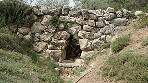
The Arkadiko Bridge or Kazarma Bridge is a Mycenaean bridge near the modern road from Tiryns to Epidauros on the Peloponnese, Greece. Dating to the Greek Bronze Age, it is one of the oldest arch bridges still in existence and use today and the oldest preserved bridge in Europe.
The corbel arch bridge belonged in Mycenaean times to a highway between the two cities, which formed part of a wider military road network. It has a culvert span of ca. 1 m and is made in the typical Mycenaean manner of Cyclopean stones. The structure is 22 metres (72 ft) long, 5.60 metres (18.4 ft) wide at the base and 4 metres (13 ft) high. The width of the roadway atop is about 2.50 metres (8 ft 2 in). The sophisticated layout of the bridge and the road indicate that they were specifically constructed for use by chariots.[1] Built in the late Late Helladic III (ca. 1300–1190 BC), the bridge is still used by the local populace.[2]
Further Mycenaean bridges in the Argolis[]

The Arkadiko Bridge is one of four known Mycenaean corbel arch bridges near Arkadiko, all belonging to the same Bronze Age highway between the two cities, and all of similar design and age. One of them is the Petrogephyri bridge, which crosses the same stream 1 km to the west of the Arkadiko bridge. Otherwise similar in size and appearance, the structure has a larger span and a little higher vault. It, too, is still used as a local track.[1]
A fifth, well-preserved Mycenaean bridge is located in the wider region at Lykotroupi in northern Argolis, where it was part of another Mycenaean main road. Its measurements are close to the Arkadiko Bridge: 5.20 metres (17.1 ft) wide at the bottom, 2.40 metres (7 ft 10 in) at the top and with a corbelled arch span of a little more than a metre. The road still features curbs for guiding fast-moving chariots.[1]
References[]
- ^ a b c R. Hope Simpson (1998)
- ^ Hellenic Ministry of Culture: Mycenaean bridge at Kazarma Archived April 8, 2008, at the Wayback Machine
Sources[]
- R. Hope Simpson, D. K. Hagel: "Mycenaean Fortifications, Highways, Dams and Canals", Paul Aströms Förlag, Sävedalen, in: Studies in Mediterranean Archaeology, Vol. CXXXIII ISBN 91-7081-212-8
- R. Hope Simpson, "The Mycenaean Highways", Classical Views, XLII, n.s. 17 (1998), 239–260
Further reading[]
- Anton Jansen: "Bronze Age Highways at Mycenae", Classical Views, XLI, n.s. 16 (1997), 1–16
External links[]
![]() Media related to Kazarma bridge at Wikimedia Commons
Media related to Kazarma bridge at Wikimedia Commons
- Arkadiko Bridge at Structurae
- Mycenaean bridge at Kazarma, Hellenic Ministry of Culture
Coordinates: 37°35′37″N 22°56′15″E / 37.59361°N 22.93750°E
- Mycenaean sites in Argolis
- Bridges completed in the 2nd millennium BC
- Ancient bridges in Greece
- Corbel arch bridges
- Stone bridges in Greece
- 2nd-millennium BC establishments