Arkansas Highway 367
 | ||||
|---|---|---|---|---|
 | ||||
| Route information | ||||
| Maintained by ArDOT | ||||
| Section 1 | ||||
| Length | 15.03 mi[1] (24.19 km) | |||
| South end | ||||
| North end | ||||
| Section 2 | ||||
| Length | 81.52 mi[1] (131.19 km) | |||
| South end | ||||
| North end | ||||
| Highway system | ||||
| ||||
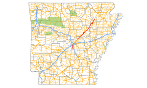
Arkansas Highway 367 (AR 367 or Hwy. 367) is a designation for two north–south state highways in Arkansas. A southern route of 15.03 miles (24.19 km) travels north from U.S. Route 167 (US 167) in East End north to US 70 in Little Rock.[2][3] A northern route of 81.52 miles (131.19 km) begins in Cabot at US 67/AR 5/AR 321 and travels northeast to US 412 in Walnut Ridge.[4][5]
Route description[]
East End to Little Rock[]
The southern segment begins in Little Rock, Arkansas at an intersection with US 70 (Roosevelt Road) as part of Arch Street. Its southern terminus is at an intersection with US 167 south of East End, Arkansas. Traveling generally north to south, it is a former alignment of US 167. It is commonly known as "Arch Street" or "Arch Street Pike" after the Little Rock street.
Cabot to Walnut Ridge[]
The northern segment begins at an intersection with US 412 and AR 34 at Walnut Ridge; its southern terminus is in Cabot, Arkansas at an intersection with US 67, AR 5, and AR 321. Traveling mostly northeast to southwest, it is a former alignment of US 67.


Major intersections[]
| County | Location | mi | km | Destinations | Notes | |||
|---|---|---|---|---|---|---|---|---|
| Saline | East End | 0.0 | 0.0 | |||||
| Pulaski | | 9.6 | 15.4 | |||||
| Little Rock | 10.5 | 16.9 | ||||||
| 15.0 | 24.1 | |||||||
| Gap in route | ||||||||
| Lonoke | Cabot | 0.0 | 0.0 | |||||
| 3.3 | 5.3 | |||||||
| 4.7 | 7.6 | |||||||
| Austin | 5.8 | 9.3 | ||||||
| Ward | 8.3 | 13.4 | ||||||
| 8.7 | 14.0 | |||||||
| White | Beebe | 12.4 | 20.0 | |||||
| 13.1 | 21.1 | |||||||
| 14.2 | 22.9 | |||||||
| McRae | 18.6 | 29.9 | ||||||
| 26.3 | 42.3 | |||||||
| Searcy | 27.2 | 43.8 | ||||||
| Gap in route | ||||||||
| 0.0 | 0.0 | |||||||
| 0.6 | 0.97 | |||||||
| 0.8 | 1.3 | |||||||
| 2.4 | 3.9 | |||||||
| 4.0– 4.2 | 6.4– 6.8 | |||||||
| Judsonia | 5.6 | 9.0 | ||||||
| 7.3 | 11.7 | |||||||
| 7.6 | 12.2 | |||||||
| 7.8 | 12.6 | |||||||
| 8.4 | 13.5 | |||||||
| Bald Knob | 12.4 | 20.0 | ||||||
| Gap in route | ||||||||
| 0.0 | 0.0 | |||||||
| 0.9 | 1.4 | |||||||
| Bradford | 9.5 | 15.3 | ||||||
| Jackson |
No major junctions | |||||||
| Independence |
No major junctions | |||||||
| Jackson | | 25.6 | 41.2 | Southern end of Hwy 14 overlap | ||||
| Newport | Newport Bridge over White River | |||||||
| Remmel Avenue | former AR 224 east | |||||||
| 27.8 | 44.7 | |||||||
| Pecan Street | former AR 17 north | |||||||
| 28.8 | 46.3 | Northern end of Hwy 14 overlap | ||||||
| 29.4 | 47.3 | |||||||
| Newport–Diaz line | 31.5 | 50.7 | ||||||
| Diaz | 32.7 | 52.6 | ||||||
| Tuckerman | 38.2 | 61.5 | ||||||
| 38.7 | 62.3 | |||||||
| 39.0 | 62.8 | |||||||
| | 40.1 | 64.5 | ||||||
| | 44.2 | 71.1 | ||||||
| Lawrence | Alicia | 51.6 | 83.0 | |||||
| Minturn | 58.0 | 93.3 | ||||||
| Hoxie | 63.0 | 101.4 | ||||||
| 63.7 | 102.5 | Southern end of US 63 Business overlap | ||||||
| 64.0 | 103.0 | Northern end of US 63 Business overlap | ||||||
| Walnut Ridge | 65.7 | 105.7 | ||||||
1.000 mi = 1.609 km; 1.000 km = 0.621 mi
| ||||||||
Beebe spur[]
Highway 367S | |
|---|---|
| Location | Beebe, Arkansas |
| Length | 0.49 mi[1] (790 m) |
Highway 367 Spur (AR 367S, Hwy. 367S) is a spur route of 0.49 miles (0.79 km) in Beebe, Arkansas.[1]
The northern terminus is at an intersection with US 67 / US 167/ US 64 (Future I-57) north of Beebe. Arkansas. Its southern terminus is in Beebe at an intersection with AR 367. It continues south as N. Pecan St.
See also[]
References[]
- ^ a b c d Planning and Research Division (2010). "Arkansas Road Log Database". Arkansas State Highway and Transportation Department. Archived from the original (Database) on 23 June 2011. Retrieved June 9, 2011.
- ^ General Highway Map, Saline County, Arkansas (PDF) (Map). 1:62500. Cartography by Planning and Research Division. Arkansas State Highway and Transportation Department. 2010. Retrieved December 17, 2011.
- ^ General Highway Map, Pulaski County, Arkansas (PDF) (Map). 1:62500. Cartography by Planning and Research Division. Arkansas State Highway and Transportation Department. 2007. Retrieved December 17, 2011.
- ^ General Highway Map, Lonoke County, Arkansas (PDF) (Map). 1:62500. Cartography by Planning and Research Division. Arkansas State Highway and Transportation Department. 2010. Retrieved December 17, 2011.
- ^ General Highway Map, Jackson County, Arkansas (PDF) (Map). 1:62500. Cartography by Planning and Research Division. Arkansas State Highway and Transportation Department. 2010. Retrieved December 17, 2011.
External links[]
Route map:

| ( • help)
|
![]() Media related to Arkansas Highway 367 at Wikimedia Commons
Media related to Arkansas Highway 367 at Wikimedia Commons
This Arkansas road-related article is a stub. You can help Wikipedia by . |
- State highways in Arkansas
- Transportation in Independence County, Arkansas
- Transportation in Jackson County, Arkansas
- Transportation in Lonoke County, Arkansas
- Transportation in Pulaski County, Arkansas
- Transportation in Saline County, Arkansas
- Transportation in White County, Arkansas
- U.S. Route 67
- Arkansas road stubs