Arkansas Highway 9
 | ||||
|---|---|---|---|---|
 | ||||
| Route information | ||||
| Maintained by ArDOT | ||||
| Existed | April 1, 1926[1]–present | |||
| Section 1 | ||||
| Length | 51.44 mi[2] (82.78 km) | |||
| South end | ||||
| North end | ||||
| Section 2 | ||||
| Length | 174.17 mi[2] (280.30 km) | |||
| South end | ||||
| North end | ||||
| Location | ||||
| Counties | Ouachita, Dallas, Hot Spring, Saline, Perry, Conway, Van Buren, Stone, Izard, Fulton | |||
| Highway system | ||||
| ||||

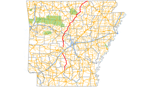
Highway 9 (AR 9) is a designation for two north–south state highways in Arkansas. A southern segment of 51.44 miles (82.78 km) begins at U.S. Route 79 at and heads north to U.S. Route 67 in Malvern before terminating.[3] The northern segment of 174.17 miles (280.30 km) runs from AR 5 to U.S. Route 63 in Mammoth Spring.[4] The route was created during the 1926 Arkansas state highway numbering, and has seen only minor extensions and realignments since. Pieces of both routes are designated as Arkansas Heritage Trails for use during the Civil War and the Trail of Tears.
The AR 9 designation also extends to two spur routes and one business route. All routes are maintained by the Arkansas Department of Transportation (ArDOT).
Route description[]
Eagle Mills to Malvern[]
Highway 9 begins at US 67 in Malvern and heads south through , Tulip, and Princeton before heading slightly west.[5] The route then passes through and past numerous quarries before terminating at US 79 at .[6]
Crows to Mammoth Spring[]

AR 9 begins at Crows and runs north, with AR 298 shooting east from the route.[7] Continuing north into Perry County, AR 9 meets AR 10 at Williams Junction with AR 216 detaching near Harris Rake. The route next meets AR 60 in Perryville before entering Conway County.[8] The route runs with AR 113 and AR 247 briefly south of Morrilton before meeting US 64 and I-40. AR 9 has a spur and business route in Morrilton. AR 915 strays from AR 9 near Overcup Lake. AR 9 also runs with AR 92 from to Center Ridge in Conway County.[9] AR 9 concurs with US 65 from Choctaw to Clinton. The route continues to Shirley from Clinton with AR 16, where it is crossed by AR 110.[10] Entering Stone County, AR 9 runs north for several miles before meeting AR 66 in Mountain View. It exits town northbound with AR 5 and AR 16.[11] AR 9 arrows east in Izard County, passing , a former alignment of AR 9. The route mostly follows the White River in eastern Izard County. AR 9 detaches a spur route and meets AR 69 in Melbourne. The route then meets AR 56 in Brockwell before leaving the county.[12] The route enters its final county, meeting AR 395 before meeting US 62/US 412 and US 62 BUS in Salem. The route trails northeast to Mammoth Spring, where it meets US 63 and terminates, near the Missouri state line.[13]
History[]
AR 9 was one of the original state highways, designated in 1926.[1] State Road 9 ran from US Highway 167 (US 167) at to Malvern, and US 70 at Crows to Mammoth Spring. In September 1928, the southern terminus was relocated to US 167 at Eagle Mills.[14] The highway was rerouted south of Clinton over a short section of AR 130 near US 65 in 1953.[15] In 1972, a bypass was built around Morrilton, with the former alignment becoming AR 9B.[16]
Major intersections[]
Mile markers reset at some concurrencies.
| County | Location | mi | km | Destinations | Notes | ||
|---|---|---|---|---|---|---|---|
| Ouachita | 0.00 | 0.00 | |||||
| | |||||||
| Dallas | |||||||
| | |||||||
| | 20.25– 0.00 | 32.59– 0.00 | |||||
| | |||||||
| | |||||||
| Hot Spring | |||||||
| Malvern | 31.19 | 50.20 | |||||
| Gap in route | |||||||
| Saline | Crows | 0.00 | 0.00 | ||||
| | |||||||
| Perry | South end of AR 10 overlap | ||||||
| | |||||||
| | |||||||
| | |||||||
| Perryville | South end of AR 60 overlap | ||||||
| North end of AR 60 overlap | |||||||
| Perry | North end of AR 10 overlap | ||||||
| Conway | Oppelo | ||||||
| | |||||||
| Morrilton | |||||||
| 43.83 | 70.54 | Interchange | |||||
| I-40 exit 108 | |||||||
| | |||||||
| Solgohachia | |||||||
| | South end of AR 92 overlap | ||||||
| Center Ridge | |||||||
| North end of AR 92 overlap | |||||||
| Van Buren | |||||||
| Choctaw | 51.06 | 82.17 | South end of US 65 overlap | ||||
| Clinton | |||||||
| South end of AR 16 overlap | |||||||
| 0.00 | 0.00 | North end of US 65 overlap | |||||
| | |||||||
| Shirley | North end of AR 16 overlap | ||||||
| Stone | Rushing | South end of AR 263 overlap | |||||
| | North end of AR 263 overlap | ||||||
| Mountain View | |||||||
| South end of AR 5 / AR 14 overlap | |||||||
| Allison | North end of AR 5 / AR 14 overlap | ||||||
| White River | 30.38– 30.53 | 48.89– 49.13 | Stone–Izard county line | ||||
| Izard | Sylamore | ||||||
| Melbourne | |||||||
| 43.68 | 70.30 | ||||||
| Brockwell | |||||||
| Oxford | |||||||
| Fulton | Salem | 74.56 | 119.99 | ||||
| Mammoth Spring | |||||||
| 94.41 | 151.94 | ||||||
1.000 mi = 1.609 km; 1.000 km = 0.621 mi
| |||||||
Auxiliary routes[]
Melbourne spur[]
Highway 9S | |
|---|---|
| Location | Melbourne |
| Length | 0.90 mi[2] (1,450 m) |
| Existed | January 23, 1974[17]–present |
Highway 9S (AR 9S, Ark. 9S, and Hwy. 9S) is a spur route of 0.90 miles (1.45 km) in Melbourne. It is known colloquially as Circle Drive and Main Street.[18]
The route was created in January 1974 along Main Street,[17] and extended south along Circle Drive in 1985.[19]
Major intersections
The entire route is in Melbourne, Izard County.
| mi[2] | km | Destinations | Notes | ||
|---|---|---|---|---|---|
| 0.00 | 0.00 | Southern terminus | |||
| 0.90 | 1.45 | Northern terminus | |||
| 1.000 mi = 1.609 km; 1.000 km = 0.621 mi | |||||
Morrilton business route[]

Highway 9B | |
|---|---|
| Location | Morrilton |
| Length | 2.22 mi[2] (3.57 km) |
| Existed | February 25, 1976[16]–present |
Highway 9B (AR 9B, Ark. 9B, and Hwy. 9B) is a business route of 2.22 miles (3.57 km) in Morrilton.
Route description
AR 9B begins at AR 9 in northeast Morrilton near the parent route's junction with I-40. The route curves southwest along the edge of the University of Arkansas Community College at Morrilton campus before serving as the eastern terminus of AR 132, known as University Boulevard. AR 9B continues southwest through a commercial area with residential subdivisions until intersecting AR 247 (Poor Farm Road) near Morrilton High School. AR 9B continues west for two blocks before turning south onto Saint Joseph Street toward downtown Morrilton. The Earl Building, a 1926 automotive dealership building listed on the National Register of Historic Places, is located on Saint Joseph Street near the US 64 junction. The route terminates at US 64 (Broadway Street) near the Union Pacific Railroad tracks.[20]
History
The route was created from a former alignment of AR 9 in 1976.[16] On May 14, 1997, the portion of the route south of US 64 was removed from the state highway system and turned back to city maintenance. The turnback was made at the request of the mayor of Morrilton in exchange for extending AR 132 from AR 247 to AR 95.[21]
Major intersections
The entire route is in Morrilton, Conway County.
| mi[2] | km | Destinations | Notes | ||
|---|---|---|---|---|---|
| 0.00 | 0.00 | Northern terminus | |||
| AR 132 eastern terminus | |||||
| AR 247 southern terminus | |||||
| 2.22 | 3.57 | Southern terminus | |||
| 1.000 mi = 1.609 km; 1.000 km = 0.621 mi | |||||
Morrilton spur[]
Highway 9S | |
|---|---|
| Location | Morrilton |
| Length | 0.47 mi[2] (760 m) |
| Existed | January 30, 1986[22]–present |
Highway 9S (AR 9S, Ark. 9S, and Hwy. 9S) is a spur route of 0.47 miles (0.76 km) in Morrilton. The route was created as an industrial access drive to the Morrilton Packing Company plant at the request of the Conway County judge in 1986.[22] It was initially only 2,700 feet (820 m) in length, but was extended north due to another industry locating in the Morrilton Industrial Park on January 8, 1987.[23]
Major intersections
The entire route is in Morrilton, Conway County.
| mi[2] | km | Destinations | Notes | ||
|---|---|---|---|---|---|
| 0.00 | 0.00 | Southern terminus | |||
| 0.47 | 0.76 | End state maintenance | Southern terminus | ||
| 1.000 mi = 1.609 km; 1.000 km = 0.621 mi | |||||
See also[]
References[]
- ^ a b Arkansas State Highway Commission (April 1, 1926). Map of the State of Arkansas Showing System of State Highways (TIF) (Map). Little Rock: Arkansas State Highway Commission. Retrieved December 15, 2016.
- ^ a b c d e f g h System Information and Research Division (2014). "Arkansas Road Log Database" (MDB (inside ZIP)). Arkansas State Highway and Transportation Department. Retrieved March 27, 2016.
- ^ General Highway Map - Hot Spring County, Arkansas (PDF) (Map) (11/29/07 ed.). Arkansas State Highway and Transportation Department. Retrieved March 23, 2011.
- ^ General Highway Map - Fulton County, Arkansas (PDF) (Map) (4/11/03 ed.). Arkansas State Highway and Transportation Department. Retrieved March 23, 2011.
- ^ General Highway Map - Dallas County, Arkansas (PDF) (Map) (1/29/09 ed.). Arkansas State Highway and Transportation Department. Retrieved March 23, 2011.
- ^ General Highway Map - Ouachita County, Arkansas (PDF) (Map) (3/31/08 ed.). Arkansas State Highway and Transportation Department. Retrieved March 23, 2011.
- ^ Arkansas State Highway and Transportation Department. AHTD Saline County map Retrieved on May 8, 2009.
- ^ Arkansas State Highway and Transportation Department. AHTD Perry County map Retrieved on May 8, 2009.
- ^ Arkansas State Highway and Transportation Department. AHTD Conway County map Retrieved on May 8, 2009.
- ^ Arkansas State Highway and Transportation Department. AHTD Van Buren County map Retrieved on May 8, 2009.
- ^ Arkansas State Highway and Transportation Department. AHTD Stone County map Retrieved on May 8, 2009.
- ^ Arkansas State Highway and Transportation Department. AHTD Izard County map Retrieved on May 8, 2009.
- ^ Arkansas State Highway and Transportation Department. AHTD Fulton County map Retrieved on May 8, 2009.
- ^ Arkansas State Highway Commission (September 1, 1928). Map of the State of Arkansas Showing System of State Highways (TIF) (Map). Little Rock: Arkansas State Highway Commission. Retrieved November 19, 2017.
- ^ Arkansas State Highway Commission (1953). Official Highway Map of Arkansas (TIF) (Map). Little Rock: Arkansas State Highway Commission. Retrieved November 19, 2017.
- ^ a b c "Minutes" (1970–1979), p. 624.
- ^ a b "Minutes" (1970–1979), p. 913.
- ^ Arkansas State Highway and Transportation Department (March 2004). Map of Melbourne, Izard County, Arkansas (PDF) (Map). Little Rock: Arkansas State Highway and Transportation Department. Retrieved November 19, 2017.
- ^ "Minutes" (1980–1989), p. 566.
- ^ Arkansas Department of Transportation (September 2017). Map of Morrilton, Conway County, Arkansas (PDF) (Map). Little Rock: Arkansas Department of Transportation. Retrieved November 19, 2017.
- ^ "Minutes" (1990–1999), p. 923.
- ^ a b "Minutes" (1980–1989), p. 671.
- ^ "Minutes" (1980–1989), p. 782.
- "Minutes of the Meeting" (PDF). Arkansas State Highway Commission. 1970–1979. Retrieved December 4, 2016.
- "Minutes of the Meeting" (PDF). Arkansas State Highway Commission. 1980–1989. Retrieved December 4, 2016.
- "Minutes of the Meeting" (PDF). Arkansas State Highway Commission. 1990–1999. Retrieved December 4, 2016.
External links[]
Route map:

| ( • help)
|
![]() Media related to Arkansas Highway 9 at Wikimedia Commons
Media related to Arkansas Highway 9 at Wikimedia Commons
- State highways in Arkansas
- Transportation in Saline County, Arkansas
- Transportation in Perry County, Arkansas
- Transportation in Conway County, Arkansas
- Transportation in Van Buren County, Arkansas
- Transportation in Stone County, Arkansas
- Transportation in Izard County, Arkansas
- Transportation in Fulton County, Arkansas
- Transportation in Hot Spring County, Arkansas
- Transportation in Ouachita County, Arkansas
- Transportation in Dallas County, Arkansas