Arthur R. Bowman Dam
| Arthur R. Bowman Dam | |
|---|---|
 | |
| Location | Crook County, Oregon, USA |
| Coordinates | 44°6′44″N 120°47′12″W / 44.11222°N 120.78667°WCoordinates: 44°6′44″N 120°47′12″W / 44.11222°N 120.78667°W |
| Opening date | 1961[1] |
| Dam and spillways | |
| Impounds | Crooked River |
| Height | 245 feet (75 m)[1] |
| Length | 800 feet (244 m)[1] |
| Reservoir | |
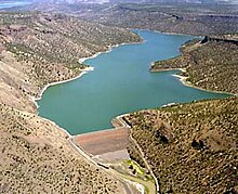
| Creates | Prineville Reservoir |
| Total capacity | 233,150 acre-feet (0.288 km3)[1] |
| Catchment area | 2,300 square miles (5,960 km2)[1] |
| Surface area | 3,580 acres (14.5 km2)[1] |

Arthur R. Bowman Dam (also known as Bowman Dam;[2] National ID # OR00579) is an earth-type irrigation dam on the Crooked River in the U.S. state of Oregon. It is in Crook County. Its reservoir is called Prineville Reservoir.
The dam was constructed by the United States Bureau of Reclamation in 1961, and is operated by the Ochoco Irrigation District.[3] The Crooked River wild and scenic area, which was designated by the Bureau of Land Management in 1988, passes through the center of Bowman Dam. Due to this designation, hydropower production is currently not allowed at the dam.[4]
In 2015, for the third time, the U.S. House of Representatives passed a Bowman Dam bill, which would authorize the city of Prineville to access about 6 percent more water from the reservoir. As of May 2015, the Bowman Dam bill has not passed the U.S. Senate.[5]
See also[]
- List of lakes in Oregon
References[]
- ^ a b c d e f "Arthur R. Bowman Dam". NPDP Dam Directory, Stanford University. Archived from the original on 2011-07-16.
- ^ "Bowman Dam". Geographic Names Information System. United States Geological Survey.
- ^ http://www.usbr.gov/projects/Facility.jsp?fac_Name=Arthur+R+Bowman+Dam&groupName=General
- ^ http://www.ktvz.com/news/for-third-time-house-passes-bowman-dam-bill/28142218
- ^ http://www.opb.org/news/article/house-passes-prineville-water-bill/
This article about a building or structure in Oregon is a stub. You can help Wikipedia by . |
This article about a dam or floodgate in the United States is a stub. You can help Wikipedia by . |
- Dams in Oregon
- Buildings and structures in Crook County, Oregon
- United States Bureau of Reclamation dams
- Dams completed in 1961
- 1961 establishments in Oregon
- Oregon building and structure stubs
- United States dam stubs