Ashland Historic District
Ashland Historic District | |
 | |
 | |
| Location | Center, Racecourse, James, Howard, Clay Sts., Hanover and Railroad Aves., Ashland, Virginia |
|---|---|
| Coordinates | 37°45′30″N 77°28′50″W / 37.75833°N 77.48056°WCoordinates: 37°45′30″N 77°28′50″W / 37.75833°N 77.48056°W |
| Area | 159 acres (64 ha) |
| Architectural style | Late 19th And 20th Century Revivals, Late Victorian, Early Commercial |
| NRHP reference No. | 83003284[1] |
| Added to NRHP | February 11, 1983 |


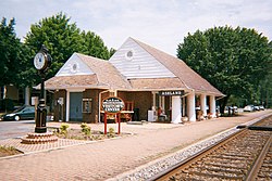
The Ashland Historic District encompasses the historic central core of Ashland, Virginia, now a suburb of nearby Richmond. The town developed in the mid-19th century as a summer resort area, but in the late 19th and early 20th century it grew more significantly as a streetcar suburb of its larger neighbor. Its central core had its biggest building boom between about 1875 and 1920, and contains a large assortment of high-quality residences in Colonial Revival, Queen Anne, and other styles. The district is centered on the junction of Center Street with Virginia State Route 54, and has a roughly cruciform shape covering 159 acres (64 ha).[2]
The district was listed on the National Register of Historic Places in 1983.[1]
See also[]
References[]
- ^ a b "National Register Information System". National Register of Historic Places. National Park Service. July 9, 2010.
- ^ "NRHP nomination for Ashland Historic District" (PDF). Virginia DHR. Archived from the original (PDF) on 2017-10-11. Retrieved 2017-10-15.
| Topics | |
|---|---|
| Lists by state |
|
| Lists by insular areas | |
| Lists by associated state | |
| Other areas | |
| Related | |
| |
Categories:
- Historic districts in Virginia
- Historic districts on the National Register of Historic Places in Virginia
- National Register of Historic Places in Hanover County, Virginia
- Victorian architecture in Virginia
- Hanover County, Virginia
- Central Virginia Registered Historic Place stubs