Atabae Administrative Post
Coordinates: 8°48′34″S 125°09′31″E / 8.80954°S 125.15850°E

This article may be expanded with text translated from the corresponding article in German. (November 2010) Click [show] for important translation instructions.
|
Administrative post of Atabae
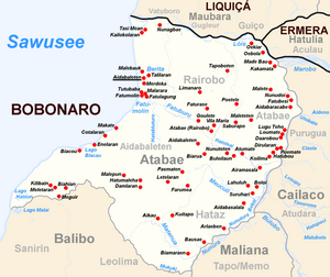
Atabae is an administrative post in the Bobonaro District of East Timor. Its population at the 2010 census was 10,976.[1] The capital of the administrative post is , which is sometimes wrongly named Atabae, too.
The real village of Atabae is in the suco of .[2]
References[]
- ^ "Direcção Nacional de Estatística: Preliminary Result of Census 2010 English" (PDF). Archived from the original (PDF) on 6 September 2014. Retrieved 28 November 2010.
- ^ "UNMIT Geographic Maps: Bobonaro District - August 2008" (PDF). Archived from the original (PDF) on 8 November 2012. Retrieved 28 November 2010.
This East Timor location article is a stub. You can help Wikipedia by . |
Categories:
- Administrative posts of East Timor
- Bobonaro Municipality
- East Timor geography stubs