Ataköy, Bakırköy
Ataköy | |
|---|---|
Quarter | |
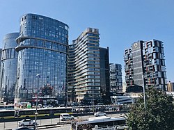 A view of Nef Ataköy | |
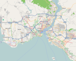 Ataköy | |
| Coordinates: 40°58′59″N 28°51′13″E / 40.98306°N 28.85361°ECoordinates: 40°58′59″N 28°51′13″E / 40.98306°N 28.85361°E | |
| Country | |
| Region | Marmara |
| Province | Istanbul |
| District | Bakırköy |
| Population (2017) | |
| • Total | 47,932 |
| Time zone | UTC+2 (EET) |
| • Summer (DST) | UTC+3 (EEST) |
| Postal code | 34156 (7th-8th-9th-10th Section) 34158 (2nd-3rd-4th-5th-6th-11th Section) |
| Area code | 0-212 |


Ataköy is a quarter of Bakırköy district in Istanbul Province, Turkey. It was developed as one of the first examples of satellite-city projects in Turkey.
Ataköy is located in Bakırköy district on the European side of Istanbul. It is adjacent to Bahçelievler district and Şirinevler neighborhood. The area in the then outskirt of Istanbul City, which Ataköy today covers, belonged to the Turkish military, and was called Baruthane (literally: gunpowder magazine). In the 1950s, the government of Prime Minister Adnan Menderes (in office (1950–1960) transferred the property to the state-owned realty business bank for envelopment as a satellite city of affordable housing for middle income households. In 1956, the project started with the construction of a beach site. The residence area was named "Ataköy" (literally "Atatürkville"). The project included 12,000 apartments, three hotels, beach, clubs, shopping malls, cultural center and sports facilities.[1]
Ataköy quarter consists of four neighborhoods with eleven sections of apartment blocks. The quarter is a peaceful residential area with wide green zones. The neighborhoods in the quarter are the Ataköy 1st Section, the 2nd-5th-6th Section, the 3rd-4th-11th Section and the 7th-8th-9th-10th Section. The 9th and 10th Sections were developed in 1986, and the 7th and 8th Sections were completed in 1990. In the recent years, some construction companies built residence blocks around the existing apartment blocks.[1]
Following facilities are situated in Ataköy: , Conservatoty of Bakırköy Municipality, Ataköy Marina, Atrium Shopping Mall, Galleria Ataköy and Ataköy A Plus Shopping Mall, Sinan Erdem Dome, Ataköy Athletics Arena.[1]
Population[]
As of 2017, the total population of the four neighborhoods in the quarter was 47,932 with the number of women exceeding that of men.
| Neighborhood | Men | Women | Total |
|---|---|---|---|
| Ataköy 1st Section[2] | 724 | 943 | 1,667 |
| Ataköy 2nd-5th-6th Section[3] | 6,343 | 7,328 | 13,671 |
| Ataköy 3rd-4th-11th Section[4] | 3,656 | 4,494 | 8,150 |
| Ataköy 7th-8th-9th-10th Section[5] | 11,228 | 13,216 | 24,444 |
| Total | 21,951 | 25,981 | 47,932 |
Transportation[]
Ataköy is served by the metro line M1 at Ataköy—Şirinevler station. The city bus lines 71T and 71AT connect the location with Taksim Square.[6][7]
References[]
| Wikimedia Commons has media related to Ataköy, Bakırköy. |
- ^ a b c "Ataköy" (in Turkish). Emlak Ansiklopedisi. Retrieved 2018-03-16.
- ^ "Ataköy 1. Kısım Mahallesi Nüfusu Bakırköy İstanbul" (in Turkish). Türkiye Nüfusu İl ilçe Mahalle Köy Nüfusları. Retrieved 2018-03-16.
- ^ "Ataköy 2-5-6. Kısım Mahallesi Nüfusu Bakırköy İstanbul" (in Turkish). Türkiye Nüfusu İl ilçe Mahalle Köy Nüfusları. Retrieved 2018-03-16.
- ^ "Ataköy 3-4-11. Kısım Mahallesi Nüfusu Bakırköy İstanbul" (in Turkish). Türkiye Nüfusu İl ilçe Mahalle Köy Nüfusları. Retrieved 2018-03-16.
- ^ "Ataköy 7-8-9-10. Kısım Mahallesi Nüfusu Bakırköy İstanbul" (in Turkish). Türkiye Nüfusu İl ilçe Mahalle Köy Nüfusları. Retrieved 2018-03-16.
- ^ "71T Ataköy - Taksim" (in Turkish). IETT. Retrieved 2018-03-17.
- ^ "71T Ataköy - Taksim" (in Turkish). IETT. Retrieved 2018-03-17.
| Neighbourhoods | |||||
|---|---|---|---|---|---|
| Transport |
| ||||
| Landmarks |
| ||||
| History | |||||
| |||||
| Regional development | |
|---|---|
| Buildings |
|
| Transport |
|
| Hydrology | |
| Industry | |
- Quarters in Istanbul
- Bakırköy