Atlas van Loon
This article relies largely or entirely on a single source. (December 2012) |
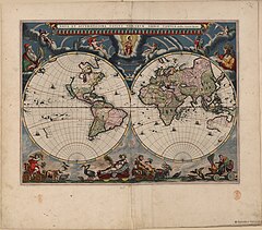
Blaeu's world map, first published in the 1664 volume of the Atlas van Loon, later reprinted
The Atlas van Loon was commissioned by of Amsterdam. It consists of a large number of maps published between 1649 and 1676:[1]
- Volumes I to IX: The Dutch edition of Joan Blaeu's Atlas Maior (Grooten Atlas) of 1663-1665
- Volumes X, XI and XII: Blaeu's city books of Italy, covering the Papal States, Rome, Naples, and Sicily, all of 1663.
- Volumes XIII and XIV: Two volumes of the French edition of Blaeu's Atlas Maior, covering France and Switzerland, both of 1663.
- Volumes XV and XVI: Blaeu's , city books covering both the Northern and the Southern Netherlands, of 1649
- Volume XVII: Pieter Goos's Zee-atlas ofte water-wereld (Maritime Atlas or Water World) of 1676
- Volume XVIII: The French edition of Johannes Janssonius's Zeeatlas (Maritime Atlas) of 1657
The Atlas van Loon was acquired by the Nederlands Scheepvaartmuseum in 1996.
See also[]
- History of cartography
- Cartography
- Ancient maps
- Willem Blaeu
References[]
External links[]
| Wikimedia Commons has media related to Atlas van Loon. |
- Digitalized maps and pictures from the Atlas Van Loon:
- Volume I: Atlas Maior I - Northern and Eastern Europe
- Volume II: Atlas Maior II - Germany and Central Europe
- Volume III: Atlas Maior III - the Low Countries
- Volume IV: Atlas Maior IV - England and Wales
- Volume V: Atlas Maior V - Scotland and Ireland
- Volume VI: Atlas Maior VI - France
- Volume VII: Atlas Maior VII - Italy and Greece
- Volume VIII: Atlas Maior VIII - Spain, Portugal, Africa and America
- Volume IX: Atlas Maior IX - Asia
- Volume X: Italian Cities I - the Papal State
- Volume XI: Italian Cities II - Rome
- Volume XII: Italian Cities III - Naples and Sicily
- Volume XIII: French edition Atlas Maior VII - France
- Volume XIV: French edition Atlas Maior VIII - France and Switzerland
- Volume XV: Tooneel der Steeden I - cities and fortifications of the Dutch Republic
- Volume XVI: Tooneel der Steeden II - cities and fortifications of the Spanish Netherlands
- Volume XVII: Goos' Zee-atlas ofte water-wereld
- Volume XVIII: Janssonius' Zeeatlas
Categories:
- Atlases
- 1665 books
- 17th-century Dutch books
- Cartography in the Dutch Republic