Attur, Virajpet
Attur
Atthur | |
|---|---|
village | |
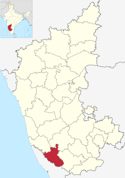 Kodagu district | |
| Country | |
| State | Karnataka |
| District | Kodagu |
| Taluk | Virajpet |
| Government | |
| • Body | Village Panchayat |
| Languages | |
| • Official | Kannada, Kodava |
| Time zone | UTC+5:30 (IST) |
| PIN | 571253 |
| Vehicle registration | KA-12 |
| Nearest city | Madikeri |
| Civic agency | Village Panchayat |
Atthur is a small village near Gonikoppa in Virajpet Taluk of Kodagu District, Karnataka State, India. It comes under Guhya Panchayath. It belongs to Mysore Division. It is located 37 km (23 mi) towards South from District headquarters Madikeri and 240 km (150 mi) from State capital Bangalore.
Madikeri, Mattannur, Koothuparamba, Mangalore, Peringathur are the nearby cities to Atthur.[1] It is located in the Virajpet taluk of Kodagu district in Karnataka.
Institutes[]
- Fruit Research Station[2]
People from Attur[]
- C. M. Poonacha, The only Chief Minister of Coorg,[3] before its merger with Mysore State.[4]
See also[]
- Kodagu
- Districts of Karnataka
References[]
- ^ "IMIS". Retrieved 31 October 2017.
{{cite web}}: CS1 maint: url-status (link)Ministry of drinking water and Sanitation - ^ "Chapter VIII Other Departments" (PDF). Retrieved 31 October 2017.
{{cite web}}: CS1 maint: url-status (link)Mysore (Karnataka) State Gazette - ^ "CM Poonacha". Retrieved 31 October 2017.
{{cite web}}: CS1 maint: url-status (link)Lok Sabha Members Profile - ^ [1] Archived 22 September 2010 at the Wayback Machine
External links[]
This article related to a location in Kodagu district, Karnataka, India is a stub. You can help Wikipedia by . |
Categories:
- Villages in Kodagu district
- Mysore Division geography stubs