Axel Heiberg Island
Native name: ᐅᒥᖕᒪᑦ ᓄᓈᑦ | |
|---|---|
 Shaded relief map of Axel Heiberg Island. Note that the colours are indicative of elevation, not foliage or ground cover | |
 Location of Axel Heiberg Island | |
 Axel Heiberg | |
| Geography | |
| Location | Arctic Ocean |
| Coordinates | 79°45′N 091°00′W / 79.750°N 91.000°W[1]Coordinates: 79°45′N 091°00′W / 79.750°N 91.000°W[1] |
| Archipelago | Sverdrup Islands Queen Elizabeth Islands Arctic Archipelago |
| Area | 43,178 km2 (16,671 sq mi) |
| Area rank | 32nd |
| Length | 371 km (230.5 mi) |
| Width | 220–246 km (137–153 mi) |
| Highest elevation | 2,210 m (7250 ft) |
| Highest point | Outlook Peak |
| Administration | |
Canada | |
| Territory | Nunavut |
| Region | Qikiqtaaluk |
| Demographics | |
| Population | 0 |


Axel Heiberg Island (Inuktitut: ᐅᒥᖕᒪᑦ ᓄᓈᑦ, Umingmat Nunaat) is an uninhabited island in the Qikiqtaaluk Region, Nunavut, Canada. Located in the Arctic Ocean, it is the 32nd largest island in the world and Canada's seventh largest island. According to Statistics Canada,[2] it has an area of 43,178 km2 (16,671 sq mi). It is named after Axel Heiberg.
One of the larger members of the Arctic Archipelago, it is also a member of the Sverdrup Islands and Queen Elizabeth Islands. It is known for its unusual fossil forests, which date from the Eocene period.[3] Owing to the lack of mineralization in many of the forest specimens, the traditional characterization of "fossilisation" fails for these forests and "mummification" may be a clearer description. The fossil records provide strong evidence that the Axel Heiberg forest was a high-latitude wetland forest.[4]
History[]


Axel Heiberg Island has been inhabited in the past by the Inuit,[5][6] but was uninhabited by the time it was named by Otto Sverdrup, who explored it in 1900–01. He named it after Axel Heiberg, financial director of the Norwegian Ringnes brewery which sponsored the expedition.[7] Other explorers visited the island during the early 20th century, during which time it was claimed by Norway until 1930. It is now part of Nunavut Territory, Canada. It wasn't until the late 1940s that the island was aerially photographed by the United States Army Air Forces' Operation Polaris. In 1955 two geologists of the Geological Survey of Canada, N.J. McMillan and Souther traversed the interior as part of Operation Franklin. McMillan's observations of Bunde Glacier, in northwest Axel Heiberg Island, are the earliest glaciological observations on the ground to have found their way into a scientific publication.
In 1959, scientists from McGill University explored Expedition Fiord (previously Sør Fjord or South Fiord) in central Axel Heiberg Island. This resulted in the establishment of the McGill Arctic Research Station (79°26′N 90��46′W / 79.433°N 90.767°W), constructed 8 km (5.0 mi) inland from Expedition Fjord in 1960. It consists of a small research hut, a cookhouse and 2 temporary structures that can comfortably accommodate 8–12 persons. The station was initially heavily utilized during the early 1960s, during which a population of 20 was present. The McGill Arctic Research Station is active from March to August with research currently focused on polar geomorphology, geology, glaciology, permafrost, climate change, and polar microbiology. Over the last 10–15 years, it has served as a significant Mars analogue for astrobiology investigations studying life and habitability of polar cryoenvironments and field-testing planetary exploration instrumentation platforms.
In the summer of 1972, a British Army Mountaineering Association expedition resulted in the naming of Scaife Glacier, following the accidental death of Sergeant Kenneth Scaife.
During the summer of 1986, a Canadian expedition headed by Dr. James Basinger set out to investigate a very unusual fossil forest on Axel Heiberg. The findings of these and subsequent expeditions have since been popularly reported in Canada.[8][9][10] Over 40 million years ago during the Eocene epoch, a forest of tall trees flourished on Axel Heiberg Island. The trees reached up to 35 m (110 ft) in height; some may have grown for 500 to 1,000 years. At the time, the polar climate was warm, but the winters were still continuously dark for three months. As the trees fell, the fine sediment in which the forest grew protected the plants. Instead of turning into petrified "stone" fossils, they were ultimately mummified by the cold, dry Arctic climate, and only recently exposed by erosion.[11]
As late as 1999, the preservation of this unique site was a concern, as the fossil wood was easily damaged and eroded once exposed. There were concerns that wood was being taken by Arctic cruise ship tourists, and that the site was being disturbed by Canadian military helicopters from a nearby base, and even by scientists themselves in their studies.[12] There were calls for more protection for the area. It currently has no official status, in part because land claims had to be settled. But now Nunavut is looking at how best to protect the fossil forest, possibly by setting up a territorial park to be called Napaaqtulik, "where there are trees".[11][13]
Interesting animal fossils have been discovered on the island, including a remarkably preserved specimen of an ancient Aurorachelys turtle and, identified in 2016, the humerus of a Tingmiatornis bird.[14][15]
Glaciation[]
White Glacier is a valley glacier occupying 38.7 km2 (14.9 sq mi) in the Expedition Fiord area of Axel Heiberg Island (79°30′N 090°50′W / 79.500°N 90.833°W). It extends in elevation from 56 to 1,782 m (184 to 5,846 ft) above sea level, a range which, as noted by Dyurgerov (2002),[16] is exceeded only by Devon Ice Cap in the world list of glaciers with measured mass balance. Ice thickness reaches or exceeds 400 m (1,300 ft). Its maximum extension in recent history, marking the advance of the glacier in response to the cooling of the Little Ice Age, was reached not earlier than the late 18th century, and more probably at the beginning of the 20th century. There is evidence that the retreat of the terminus, previously at about 5 m (16 ft) per year, is decelerating (Cogley et al. 1996a; Cogley and Adams 2000). White Glacier has been the subject of many papers in the glaciological literature since 1960, e.g.[17][18][19] Müller (1962)[17] was the source of a now-classical diagram elaborating and illustrating the concept of "glacier facies".
Population[]
The island is uninhabited except for the seasonal McGill Arctic Research Station operated by McGill University.
Lost Hammer Spring[]
The Lost Hammer Spring, located in the central west region of the island (79°07′N 090°21′W / 79.117°N 90.350°W) is the coldest and saltiest of all Arctic springs described to date. It is characterized by a perennial hypersaline (24%) discharge at subzero temperatures (~−5 °C (23 °F)) flowing to the surface through a hollow, 2 m (6 ft 7 in) high cone-shaped salt tufa structure. Continuous gas emissions from the spring indicate an underlying thermogenic methane source. On the basis of these properties, this spring is considered a significant astrobiology analogue site for possible habitats currently present on Mars and the cold moons Europa and Enceladus.
Views of the island[]

Glacier Fiord, Axel Heiberg Island

View from Wolf Mountain over the Expedition Valley towards southern Axel Heiberg Island. June 24, 1975.

Outcrops on Axel Heiberg Island
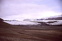
Axel Heiberg Island, Expedition Valley with White Glacier (left) and Thompson Glacier (right). July 3, 1988


See also[]
References[]
- ^ "Axel Heiberg Island". Geographical Names Data Base. Natural Resources Canada.
- ^ Area of major sea islands, by region Archived August 12, 2004, at the Wayback Machine
- ^ "The Fossilized Forest Of Axel Heiberg Island". The University of British Columbia. Retrieved 15 November 2019.
- ^ Williams, C.J.; Johnson, A.H.; LePage, B.A.; Vann, D.R.; Sweda, T. (2003). "Reconstruction of Tertiary Metasequoia Forests II". Structure, Biomass and Productivity of Eocene Floodplain Forests in the Canadian Arctic". Paleobiology. 29 (2): 271–292. doi:10.1666/0094-8373(2003)029<0271:rotmfi>2.0.co;2.
- ^ Schledermann, Peter (1975). "A Late Dorset Site on Axel Heiberg Island". Arctic. 28 (4): 300. doi:10.14430/arctic2847.
- ^ Kalkreuth, Wolfgang; Sutherland, Patricia D. (1998). "The Archaeology and Petrology of Coal Artifacts from a Thule Settlement on Axel Heiberg Island, Arctic Canada". Arctic. 51 (4): 345–349. doi:10.14430/arctic2847. JSTOR 40511852.
- ^ Barr, Susan (2014-09-28). "Axel Heiberg". In Helle, Knut (ed.). Norsk biografisk leksikon (in Norwegian). Oslo: Kunnskapsforlaget. Retrieved 8 December 2016.
- ^ Thurston, Harry "Icebound Eden" in Equinox (Camden East, Ont) 3:72. 1986
- ^ Basinger, James F "Our 'Tropical' Arctic" in Canadian Geographic (Ottawa) 106:28. 1987
- ^ Foster, Janet "Journey to the Top of the World" Toronto: Greey de Pencier. 1987
- ^ Jump up to: a b http://www.nunatsiaqonline.ca/stories/article/263419_nunavut_considers_a_new_park_for_axel_heibergs_fossil_forest/ Nunatsiaq Online, 26 October
- ^ C. Bigras; M. Bilz; D. Grattan & C. Gruchy (1995). "Erosion of the Geodetic Hills Fossil Forest, Axel Heiberg Island, Northwest Territories". Arctic. 48 (4): 342–353. doi:10.14430/arctic1258.
- ^ Jahren, A.H. (2007). "The Arctic Forest of the Middle Eocene". Annual Review of Earth and Planetary Sciences. 35: 509–540. doi:10.1146/annurev.earth.35.031306.140125. S2CID 130545959.
- ^ Wall, Michael (2009-02-01). "Tropical Turtle Fossil Discovered in the High Arctic". Wired.
- ^ Bono, Richard (2016-12-19). "A Large Ornithurine Bird (Tingmiatornis arctica) from the Turonian High Arctic: Climatic and Evolutionary Implications". Nature. 6: 38876. doi:10.1038/srep38876. PMC 5171645. PMID 27991515.
- ^ Dyurgerov, M.B. (2002). "Glacier Mass Balance and Regime: Data of Measurements and Analysis". Occasional Paper 55, Institute of Arctic and Alpine Research, University of Colorado.
- ^ Jump up to: a b Müller, F. (1962). "Zonation of the accumulation area of the glaciers of Axel Heiberg Island, N.W.T." Journal of Glaciology. 4 (33): 302–310. doi:10.1017/S0022143000027623.
- ^ Blatter, H. (1987). "On the thermal regime of an arctic valley glacier: a study of White Glacier, Axel Heiberg Island, N.W.T., Canada". Journal of Glaciology. 33 (114): 200–211. doi:10.1017/S0022143000008704.
- ^ Cogley, J.G.; W.P. Adams; M.A. Ecclestone; F. Jung-Rothenhäusler & C.S.L. Ommanney (1996). "Mass balance of White Glacier, Axel Heiberg Island, N.W.T., Canada, 1960-91". Journal of Glaciology. 42 (142): 548–563. doi:10.1017/S0022143000003531.
Further reading[]
- Jackson, M P A; Harrison, J C (2006). "An Allochthonous Salt Canopy on Axel Heiberg Island, Sverdrup Basin, Arctic Canada". Geology. 34 (12): 1045. doi:10.1130/g22798a.1.
- LePage, B. A. (2001). "New Species of Picea A. Dietrich (Pinaceae) from the Middle Eocene of Axel Heiberg Island, Arctic Canada". Botanical Journal of the Linnean Society. 135 (2): 137–167. doi:10.1111/j.1095-8339.2001.tb01088.x.
- Liptzin, Daniel (2006). "A Banded Vegetation Pattern in a High Arctic Community on Axel Heiberg Island, Nunavut, Canada". Arctic, Antarctic, and Alpine Research. 38 (2): 216. doi:10.1657/1523-0430(2006)38[216:abvpia]2.0.co;2.
- Vandermark, D.; Tarduno, J. A.; Brinkman, D. B. (2006). "Late Cretaceous Plesiosaur Teeth from Axel Heiberg Island, Nunavut, Canada". Arctic. 59 (1): 79–82.
- Chih-Ying Lay, Nadia C. S. Mykytczuk, Étienne Yergeau, Guillaume Lamarche-Gagnon, Charles W. Greer, & Lyle G. Whyte, "Defining the Functional Potential and Active Community Members of a Sediment Microbial Community in a High-Arctic Hypersaline Subzero Spring," Applied and Environmental Microbiology, Volume 79 Number 12 (June 2013), p. 3637–3648. http://aem.asm.org/content/79/12/3637
External links[]
- Axel Heiberg Island in the Atlas of Canada - Toporama; Natural Resources Canada
- Axel Heiberg Island's Eocene forests
- Unearthing a Frozen Forest
- Arctic Redwood Fossils Are Clues to Ancient Climates
| show Petrified forests |
|---|
| show World's largest islands |
|---|
| show Authority control |
|---|
- Islands of the Canadian Arctic Archipelago
- Islands of Qikiqtaaluk Region
- Islands of the Queen Elizabeth Islands
- Sverdrup Islands
- Uninhabited islands of Qikiqtaaluk Region