Azanja
Azanja | |
|---|---|
Village (Selo) | |
 | |
| Country | |
| Population (2011) | |
| • Total | 4,014 |
| Time zone | UTC+1 (CET) |
| • Summer (DST) | UTC+2 (CEST) |
Azanja (Serbian Cyrillic: Азања) is a village in Central Serbia, in the municipality of Smederevska Palanka. It lies in the region of Great Morava valley, on rivers of Jezava and Jasenica. Azanja is 160 meters above mean sea level. With 4,014 residents, it is one of largest villages in Central Serbia.[1]
History[]
Name Azanja probably dates from the ages of the Ottoman Empire, from the Arabian word hazain/hazna, meaning "barn". From 1850 to 1950 it was known as the biggest village in Serbia and later as the biggest village of ex Yugoslavia. In 1950, when Azanja reached population of 12,500 it was split into three parts, Vlaški Do, Grčac and Azanja.[clarification needed] Because of the large population, in 1922 it received the status of a town (varošica).[citation needed]
Culture and education[]
Its culture happenings are mostly during the religious holidays. Village fair on Trnova Petka (8 August) has been held every year since the construction of the church in 1885. Since 1997, an ethno-culture manifestation "The days of Azanja bakings" is held during the fair, in 2006 the night of poetry and picture exhibitions. were added to the fair. There was also a "Gipsy's night" in Azanja in 2007.
There is one elementary school in Azanja, called "Radomir Lazić", Amateur Theatre Azanja and KUD Azanja (KUD - culture and arts society). At the end of 2005, a library was opened. Azanja has one football team, Šumadija.
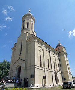
Serbian Orthodox Church of Saints Cosmas and Damian is located in the centre of the village.
Demography[]
| Population change during the 20th century |
 |
According to the data from 2011, Azanja had a population of 4014 people. There are 3,370 adults (18+), and the average age in Azanja is 45.0 years (43.1 years for men and 46.9 of woman lifetime).[1] In 1784, according to Ottoman records, Azanja had 14 Christian households, in 1942 there were 1,308 households and in 2002 there was 1,408. One family averages 3.35 persons (2002).
Coordinates: 44°26′N 20°53′E / 44.433°N 20.883°E

References[]
This article needs additional citations for verification. (December 2015) |
- ^ Jump up to: a b "2011 Census of Population, Households and Dwellings in the Republic of Serbia: Comparative Overview of the Number of Population in 1948, 1953, 1961, 1971, 1981, 1991, 2002 and 2011, Data by settlements" (PDF). Statistical Office of Republic Of Serbia, Belgrade. 2014. p. 526. ISBN 978-86-6161-109-4. Retrieved 2014-06-27.
| Wikimedia Commons has media related to Azanja. |
- Populated places in Podunavlje District